
Magnitude |
:3.5 |
| Date & Time (UTC) | 2006-10-17 04:03:25.6 |
| Date & Time (Local) | 1385/7/25 07:33:25.6 |
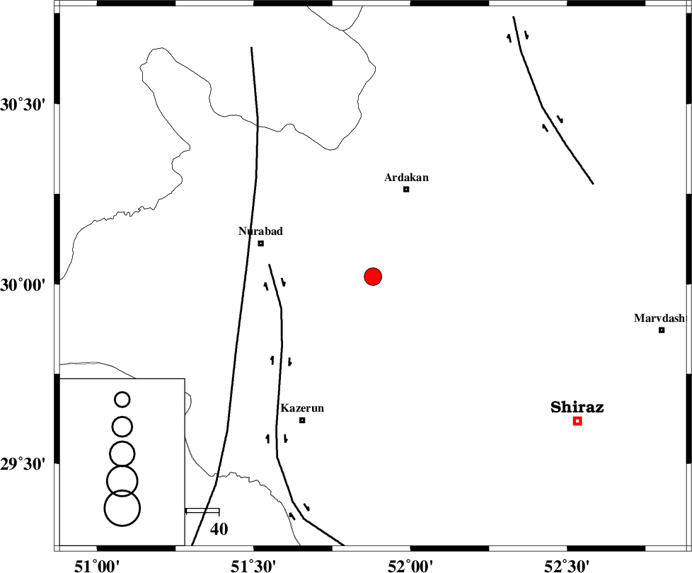
| Location | Lat:30.02 Lon: 51.88 |
| Region | 29 km South-West of Ardakan, Fars Province |
Nearest Cities |
|
| 26 km South West of Bahrghan, Fars Province | |
| 29 km South West of Ardakan, Fars Province | |
| 30 km North East of Nodan, Fars Province | |
| 34 km East of Gachgaran, Fars Province | |
| 34 km North East of Seyyed hasan, Fars Province | |
| Depth | 18 km |
| Agency | |
Faults within 150 km: |
|
| KAREBASS_F (Length: 98 km) , Distance to epicenter: 27 km | |
| KAZERUN_F (Length: 96 km) , Distance to epicenter: 28 km | |
| HZF3 (Length: 197 km) , Distance to epicenter: 30 km | |
| Number of Phases | 6 |
| RMS | 0.2 |
| Number of Stations | 5 |
| Error in Latitude | >2.4 km |
| Error in Longitude | 8.1 km |
| Error in Depth | 6.4 km |
Download waveform in seisan format
to download seisan software Click here
to access information about IIEES stations Click here
Amplitude | ||||||||
| UID | Agency | Station | Component | Amplitude | Period | Arrival Time | Proccessing Time | Signal Clip |
| 36367 | IIEES | GHIR | E | 410.8 | 0.44 | 2006-10-17 04:04:41 | 2007-01-07 07:24:00 | n |
| 36368 | IIEES | KRBR | N | 41.9 | 0.7 | 2006-10-17 04:05:51 | 2007-01-07 07:24:00 | n |
| 36369 | IIEES | KRBR | E | 63.8 | 0.67 | 2006-10-17 04:05:51 | 2007-01-07 07:24:00 | n |
| 36370 | IIEES | BNDS | E | 41.3 | 0.92 | 2006-10-17 04:05:31 | 2007-01-07 07:24:00 | n |
| 36371 | IIEES | BNDS | N | 43.6 | 0.84 | 2006-10-17 04:05:35 | 2007-01-07 07:24:00 | n |
| 36372 | IIEES | ASAO | N | 23.5 | 0.78 | 2006-10-17 04:06:11 | 2007-01-07 07:24:00 | n |
Phase | ||||||||||||
| Agency | Station | Component | Phase Type | Phase Quality | First Motion | Observed Arrival Time | Time Residual | Loc. Flag | Input Weight | Distance | Azimuth | |
| IIEES | GHIR | Z | PG | E | 2006-10-17 04:04:01 | 0.1 | y | 220 | 150 | |||
| IIEES | NASN | Z | PN | E | 2006-10-17 04:04:12 | -0.2 | y | 321 | 16 | |||
| IIEES | NASN | E | SG | E | 2006-10-17 04:04:56 | 0 | y | 321 | 16 | |||
| IIEES | KRBR | Z | PN | E | 2006-10-17 04:04:31 | 0.2 | y | 471 | 89 | |||
| IIEES | BNDS | Z | Pn | E | 2006-10-17 04:04:35 | -0.4 | y | 510 | 124 | |||
| IIEES | ASAO | Z | PN | E | 2006-10-17 04:04:39 | 0.1 | y | 532 | 341 | |||