
Magnitude |
:3.8 |
| Date & Time (UTC) | 2006-10-10 03:32:15.1 |
| Date & Time (Local) | 1385/7/18 07:02:15.1 |
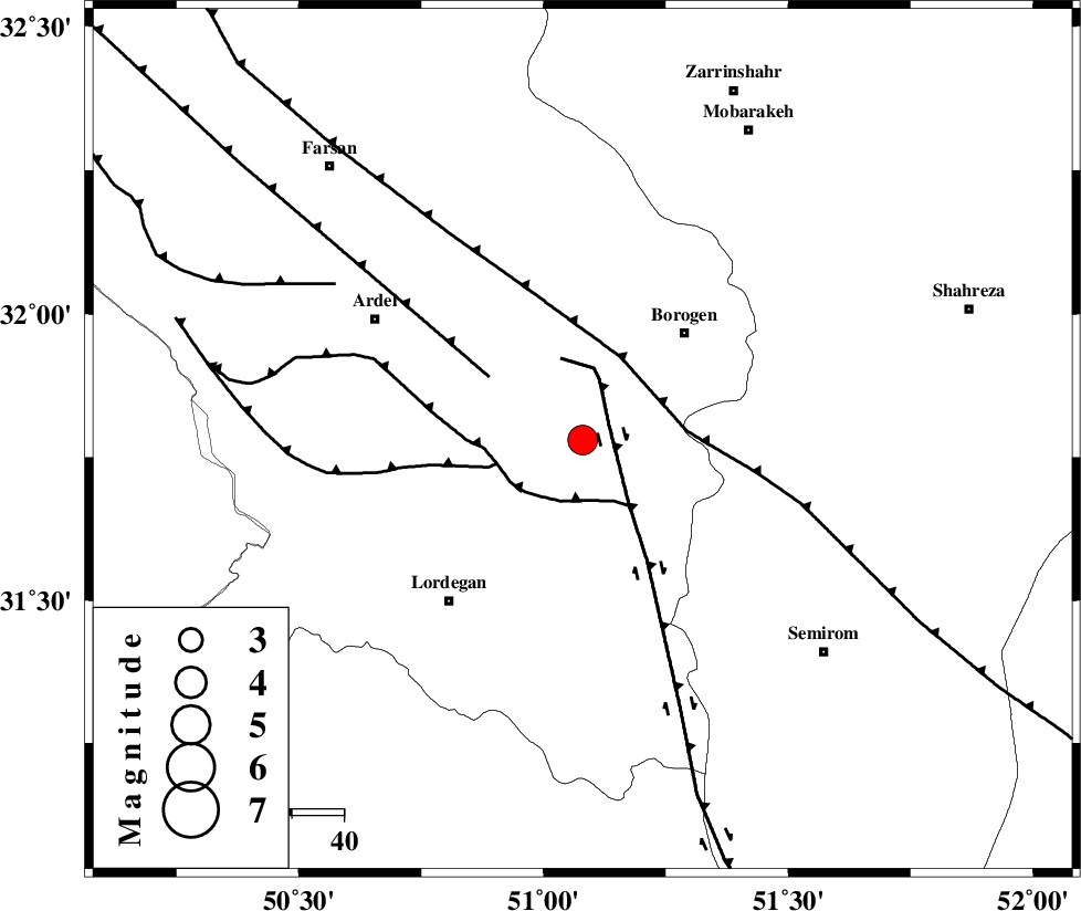
| Location | Lat:31.78 Lon: 51.08 |
| Region | 29 km South-West of Borujen, Chaharmahal Bakhtiari Province |
Nearest Cities |
|
| 12 km of Gandoman, Chaharmahal Bakhtiari Province | |
| 17 km South of Baladaji, Chaharmahal Bakhtiari Province | |
| 26 km North of Aluni, Chaharmahal Bakhtiari Province | |
| 27 km South West of Faradonbeh, Chaharmahal Bakhtiari Province | |
| 29 km South West of Borujen, Chaharmahal Bakhtiari Province | |
| Depth | 14 km |
| Agency | |
Faults within 150 km: |
|
| DENA_F (Length: 137 km) , Distance to epicenter: 6 km | |
| DOPOLAN_F (Length: 107 km) , Distance to epicenter: 12 km | |
| SABZKUH_F (Length: 67 km) , Distance to epicenter: 17 km | |
| Number of Phases | 7 |
| RMS | 0.1 |
| Number of Stations | 6 |
| Error in Latitude | >2.3 km |
| Error in Longitude | 2.3 km |
| Error in Depth | 3.9 km |
Download waveform in seisan format
to download seisan software Click here
to access information about IIEES stations Click here
Amplitude | ||||||||
| UID | Agency | Station | Component | Amplitude | Period | Arrival Time | Proccessing Time | Signal Clip |
| 36305 | IIEES | SHGR | N | 1116.2 | 0.99 | 2006-10-10 03:33:31 | 2007-01-07 07:24:00 | n |
| 36306 | IIEES | SHGR | E | 819.5 | 0.76 | 2006-10-10 03:33:39 | 2007-01-07 07:24:00 | n |
| 36307 | IIEES | ASAO | N | 426.7 | 0.29 | 2006-10-10 03:33:56 | 2007-01-07 07:24:00 | n |
| 36308 | IIEES | ASAO | E | 239.4 | 0.58 | 2006-10-10 03:34:00 | 2007-01-07 07:24:00 | n |
| 36309 | IIEES | DAMV | N | 97 | 0.64 | 2006-10-10 03:34:31 | 2007-01-07 07:24:00 | n |
Phase | ||||||||||||
| Agency | Station | Component | Phase Type | Phase Quality | First Motion | Observed Arrival Time | Time Residual | Loc. Flag | Input Weight | Distance | Azimuth | |
| IIEES | NASN | Z | PG | E | 2006-10-10 03:32:47 | -0.1 | y | 199 | 55 | |||
| IIEES | SHGR | Z | PG | E | 2006-10-10 03:32:50 | -0.1 | y | 218 | 280 | |||
| IIEES | ASAO | Z | PN | E | 2006-10-10 03:33:03 | 0.2 | y | 323 | 343 | |||
| IIEES | ASAO | E | SG | E | 2006-10-10 03:33:45 | 0 | y | 323 | 343 | |||
| IIEES | DAMV | Z | PN | E | 2006-10-10 03:33:17 | 0 | y | 435 | 11 | |||
| IIEES | THKV | Z | Pn | E | 2006-10-10 03:33:19 | -0.1 | y | 460 | 358 | |||
| IIEES | KRBR | Z | Pn | E | 2006-10-10 03:33:35 | 0.1 | y | 579 | 109 | |||