
Magnitude |
:2.6 |
| Date & Time (UTC) | 2006-08-26 01:50:34.8 |
| Date & Time (Local) | 1385/6/4 05:20:34.8 |
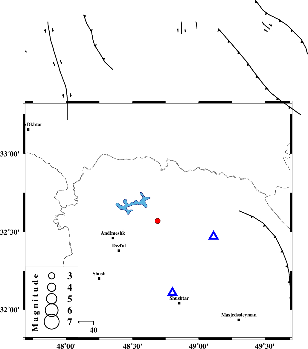
| Location | Lat:32.57 Lon: 48.69 |
| Region | 34 km North-East of Andimeshk, Khoozestan Province |
Nearest Cities |
|
| 16 km North West of Sardasht, Khoozestan Province | |
| 20 km North of Mahur berenji, Khoozestan Province | |
| 28 km South West of Shuy, Khoozestan Province | |
| 34 km North East of Andimeshk, Khoozestan Province | |
| 35 km North East of Dezful, Khoozestan Province | |
| Depth | 14 km |
| Agency | |
Faults within 150 km: |
|
| DEZFUL_EMBAYMENT (Length: 228 km) , Distance to epicenter: 16 km | |
| BALARUD_F_Z2 (Length: 58 km) , Distance to epicenter: 21 km | |
| BALARUD_F_Z3 (Length: 53 km) , Distance to epicenter: 26 km | |
| Number of Phases | 5 |
| RMS | 0.2 |
| Number of Stations | 4 |
| Error in Latitude | >3.7 km |
| Error in Longitude | 8.4 km |
| Error in Depth | 9.4 km |
Download waveform in seisan format
to download seisan software Click here
to access information about IIEES stations Click here
Amplitude | ||||||||
| UID | Agency | Station | Component | Amplitude | Period | Arrival Time | Proccessing Time | Signal Clip |
| 36081 | IIEES | SHGR | N | 553.1 | 0.44 | 2006-08-26 01:51:01 | 2006-10-17 03:59:00 | n |
| 36082 | IIEES | SHGR | E | 693.6 | 0.48 | 2006-08-26 01:51:06 | 2006-10-17 03:59:00 | n |
| 36083 | IIEES | ASAO | E | 34.3 | 0.6 | 2006-08-26 01:51:54 | 2006-10-17 03:59:00 | n |
| 36084 | IIEES | ASAO | N | 27.9 | 0.68 | 2006-08-26 01:51:59 | 2006-10-17 03:59:00 | n |
| 36085 | IIEES | SNGE | N | 20 | 0.56 | 2006-08-26 01:52:05 | 2006-10-17 03:59:00 | n |
Phase | ||||||||||||
| Agency | Station | Component | Phase Type | Phase Quality | First Motion | Observed Arrival Time | Time Residual | Loc. Flag | Input Weight | Distance | Azimuth | |
| IIEES | SHGR | Z | PG | E | 2006-08-26 01:50:43 | -0.1 | y | 52.1 | 169 | |||
| IIEES | ASAO | Z | PN | E | 2006-08-26 01:51:13 | 0 | y | 252 | 29 | |||
| IIEES | SNGE | Z | PN | E | 2006-08-26 01:51:21 | 0.3 | y | 306 | 336 | |||
| IIEES | SNGE | E | SG | E | 2006-08-26 01:52:00 | -0.2 | y | 306 | 336 | |||
| IIEES | NASN | Z | Pn | E | 2006-08-26 01:51:30 | 0 | y | 387 | 85 | |||