
Magnitude |
:3.1 |
| Date & Time (UTC) | 2006-09-21 14:21:47.7 |
| Date & Time (Local) | 1385/6/30 17:51:47.7 |
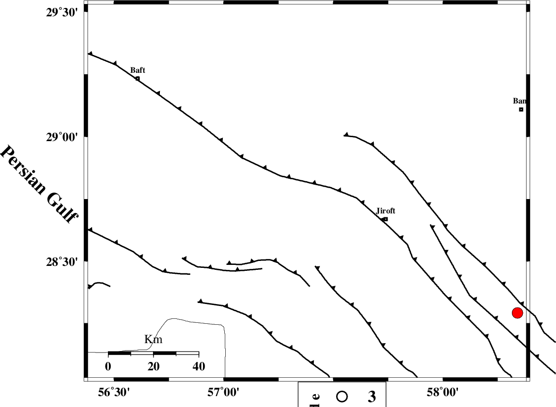
| Location | Lat:28.78 Lon: 57.38 |
| Region | 37 km North-West of Jiroft, Kerman Province |
Nearest Cities |
|
| 25 km South of Eslamabad, Kerman Province | |
| 30 km North East of Dolatabad, Kerman Province | |
| 32 km South West of Delfard, Kerman Province | |
| 34 km South West of Sahebabad, Kerman Province | |
| 37 km North West of Jiroft, Kerman Province | |
| Depth | 41 km |
| Agency | |
Faults within 150 km: |
|
| SABZEVARAN_F (Length: 190 km) , Distance to epicenter: 35 km | |
| GOWK_F (Length: 152 km) , Distance to epicenter: 61 km | |
| LALEHZAR_F (Length: 52 km) , Distance to epicenter: 88 km | |
| Number of Phases | 5 |
| RMS | 0.1 |
| Number of Stations | 3 |
| Error in Latitude | >1.4 km |
| Error in Longitude | 7.6 km |
| Error in Depth | 3.8 km |
Download waveform in seisan format
to download seisan software Click here
to access information about IIEES stations Click here
Amplitude | ||||||||
| UID | Agency | Station | Component | Amplitude | Period | Arrival Time | Proccessing Time | Signal Clip |
| 35913 | IIEES | KRBR | N | 221 | 0.24 | 2006-09-21 14:22:35 | 2006-10-17 03:59:00 | n |
| 35914 | IIEES | BNDS | N | 300.1 | 0.24 | 2006-09-21 14:22:44 | 2006-10-17 03:59:00 | n |
| 35915 | IIEES | GHIR | E | 34.9 | 0.28 | 2006-09-21 14:23:31 | 2006-10-17 03:59:00 | n |
| 35916 | IIEES | GHIR | N | 19.9 | 0.32 | 2006-09-21 14:23:33 | 2006-10-17 03:59:00 | n |
Phase | ||||||||||||
| Agency | Station | Component | Phase Type | Phase Quality | First Motion | Observed Arrival Time | Time Residual | Loc. Flag | Input Weight | Distance | Azimuth | |
| IIEES | KRBR | Z | PG | E | 2006-09-21 14:22:12 | -0.1 | y | 146 | 336 | |||
| IIEES | KRBR | N | SG | E | 2006-09-21 14:22:29 | 0.1 | y | 146 | 336 | |||
| IIEES | BNDS | Z | PG | E | 2006-09-21 14:22:19 | 0.1 | y | 194 | 218 | |||
| IIEES | BNDS | E | SG | E | 2006-09-21 14:22:42 | -0.1 | y | 194 | 218 | |||
| IIEES | GHIR | Z | PN | E | 2006-09-21 14:22:46 | 0 | y | 433 | 264 | |||