
Magnitude |
:4 |
| Date & Time (UTC) | 2026-05-21 00:17:12.7 |
| Date & Time (Local) | 1405/2/31 03:47:12.7 |
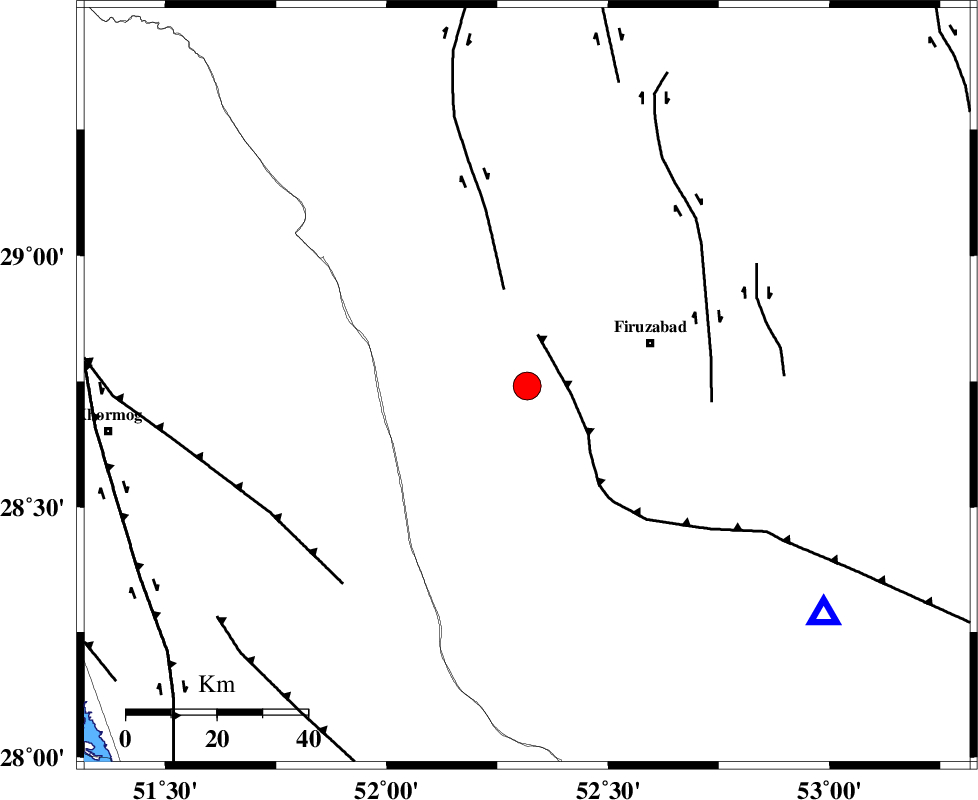
| Location | Lat:28.741 Lon: 52.317 |
| Region | Fars Province, 27 km South-East of Farashband |
Nearest Cities |
|
| 21 km West of Ahmadabad, Fars Province | |
| 27 km South East of Farashband, Fars Province | |
| 28 km North of Dahrom, Fars Province | |
| 29 km West of Firuz Abad, Fars Province | |
| 32 km West of Jaydasht, Fars Province | |
| Depth | 12 km |
| Agency | |
Faults within 150 km: |
|
| QIR_F (Length: 130 km) , Distance to epicenter: 10 km | |
| KAREBASS_F (Length: 98 km) , Distance to epicenter: 22 km | |
| SABZ_PUSHAN_F_Z1 (Length: 69 km) , Distance to epicenter: 41 km | |
| Number of Phases | 8 |
| RMS | 0.4 |
| Number of Stations | 8 |
| Error in Latitude | >2.1 km |
| Error in Longitude | 2.1 km |
| Error in Depth | 512.4 km |
Download waveform in seisan format
to download seisan software Click here
to access information about IIEES stations Click here
Amplitude | ||||||||
| UID | Agency | Station | Component | Amplitude | Period | Arrival Time | Proccessing Time | Signal Clip |
| 201804 | IIEES SC | KRVR | Z | 0.1 | 1 | 2026-05-21 00:18:28 | 2026-06-03 08:02:00 | n |
| 201805 | IIEES SC | UOSS | Z | 0.1 | 1 | 2026-05-21 00:18:31 | 2026-06-03 08:02:00 | n |
Phase | ||||||||||||
| Agency | Station | Component | Phase Type | Phase Quality | First Motion | Observed Arrival Time | Time Residual | Loc. Flag | Input Weight | Distance | Azimuth | |
| IIEES SC | KRVR | Z | EPn | E | 2026-05-21 00:18:28 | 0.1 | y | 0 | 544 | 54 | ||
| IIEES SC | UOSS | Z | EPn | E | 2026-05-21 00:18:31 | 0.2 | y | 0 | 571 | 137 | ||
| IIEES SC | GHVR | Z | EPn | E | 2026-05-21 00:18:41 | 0.5 | y | 0 | 644 | 351 | ||
| IIEES SC | HNVD | Z | EPn | E | 2026-05-21 00:18:50 | -0.3 | y | 0 | 728 | 328 | ||
| IIEES SC | KOO | Z | EPn | E | 2026-05-21 00:18:54 | -0.5 | y | 0 | 760 | 58 | ||
| IIEES SC | RAYN | Z | EPn | E | 2026-05-21 00:19:11 | -0.2 | y | 0 | 894 | 230 | ||
| IIEES SC | GIDE | Z | EPn | E | 2026-05-21 00:19:17 | 0.7 | y | 0 | 937 | 346 | ||
| IIEES SC | SRVN | Z | EPn | E | 2026-05-21 00:19:24 | -0.7 | y | 0 | 1002 | 99 | ||