
Magnitude |
:3.4 |
| Date & Time (UTC) | 2026-01-31 04:18:03.6 |
| Date & Time (Local) | 1404/11/11 07:48:03.6 |
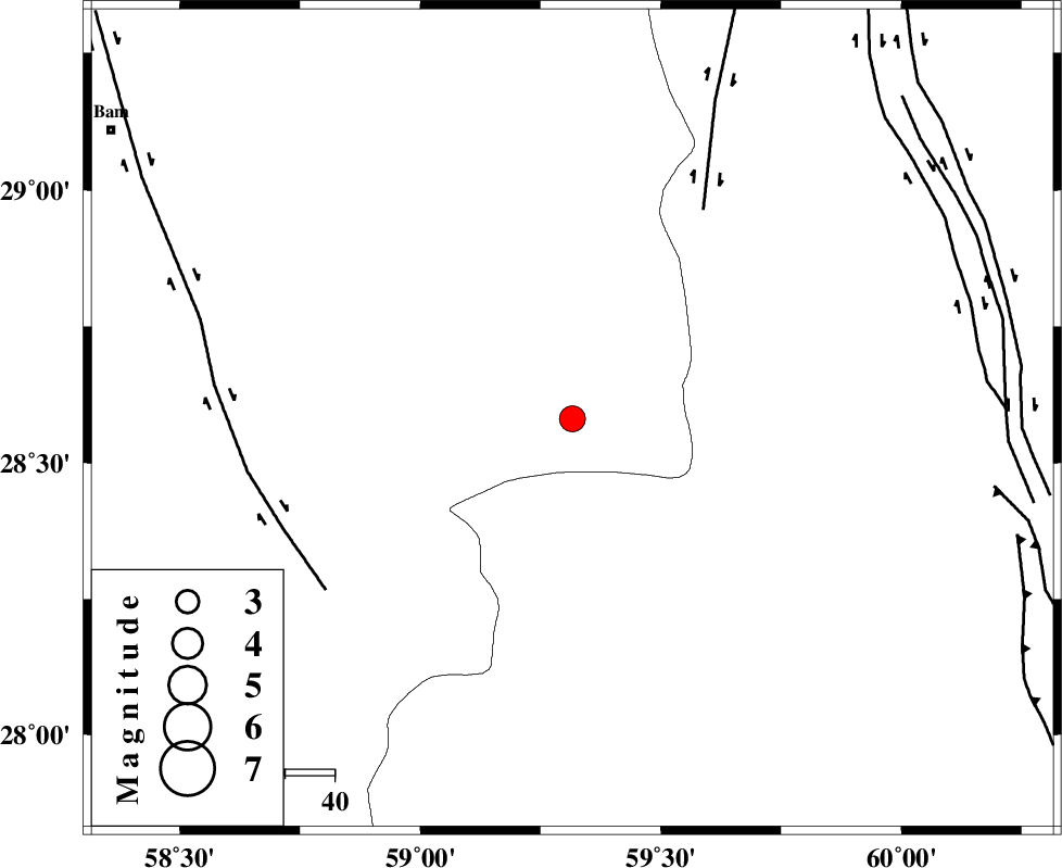
| Location | Lat:28.581 Lon: 59.316 |
| Region | Kerman Province, 110 km South-East of Bam |
Nearest Cities |
|
| 28 km South East of Hoseynabad, Kerman Province | |
| 46 km South East of Mohammadabad-e gonbaki, Kerman Province | |
| 52 km South East of Void, Kerman Province | |
| 59 km South East of Fahroj, Kerman Province | |
| 78 km South East of Qasemabad, Kerman Province | |
| Depth | 17 km |
| Agency | |
Faults within 150 km: |
|
| KANURAK_F (Length: 135 km) , Distance to epicenter: 50 km | |
| BAM_F (Length: 118 km) , Distance to epicenter: 61 km | |
| NOSRATABAD_F_Z1 (Length: 109 km) , Distance to epicenter: 84 km | |
| Number of Phases | 5 |
| RMS | 0.6 |
| Number of Stations | 5 |
| Error in Latitude | >7.3 km |
| Error in Longitude | 7.3 km |
| Error in Depth | 999 km |
Download waveform in seisan format
to download seisan software Click here
to access information about IIEES stations Click here
Amplitude | ||||||||
| UID | Agency | Station | Component | Amplitude | Period | Arrival Time | Proccessing Time | Signal Clip |
| 201689 | IIEES SC | GENO | Z | 0.2 | 1 | 2026-01-31 04:18:52 | 2026-02-24 05:51:00 | n |
| 201690 | IIEES SC | KRVR | Z | 0.07 | 1 | 2026-01-31 04:19:02 | 2026-02-24 05:51:00 | n |
Phase | ||||||||||||
| Agency | Station | Component | Phase Type | Phase Quality | First Motion | Observed Arrival Time | Time Residual | Loc. Flag | Input Weight | Distance | Azimuth | |
| IIEES SC | IRSR | Z | EPn | E | 2026-01-31 04:18:39 | -1.1 | y | 0 | 234 | 139 | ||
| IIEES SC | SRVN | Z | EPn | E | 2026-01-31 04:18:53 | 1 | y | 0 | 330 | 113 | ||
| IIEES SC | GENO | Z | EPn | E | 2026-01-31 04:18:52 | 0.1 | y | 0 | 336 | 247 | ||
| IIEES SC | KRVR | Z | EPn | E | 2026-01-31 04:19:02 | -0.2 | y | 0 | 415 | 325 | ||
| IIEES SC | KOO | Z | EPn | E | 2026-01-31 04:19:04 | -0.1 | y | 0 | 427 | 356 | ||