
Magnitude |
:3.9 |
| Date & Time (UTC) | 2026-02-15 08:02:16.2 |
| Date & Time (Local) | 1404/11/26 11:32:16.2 |
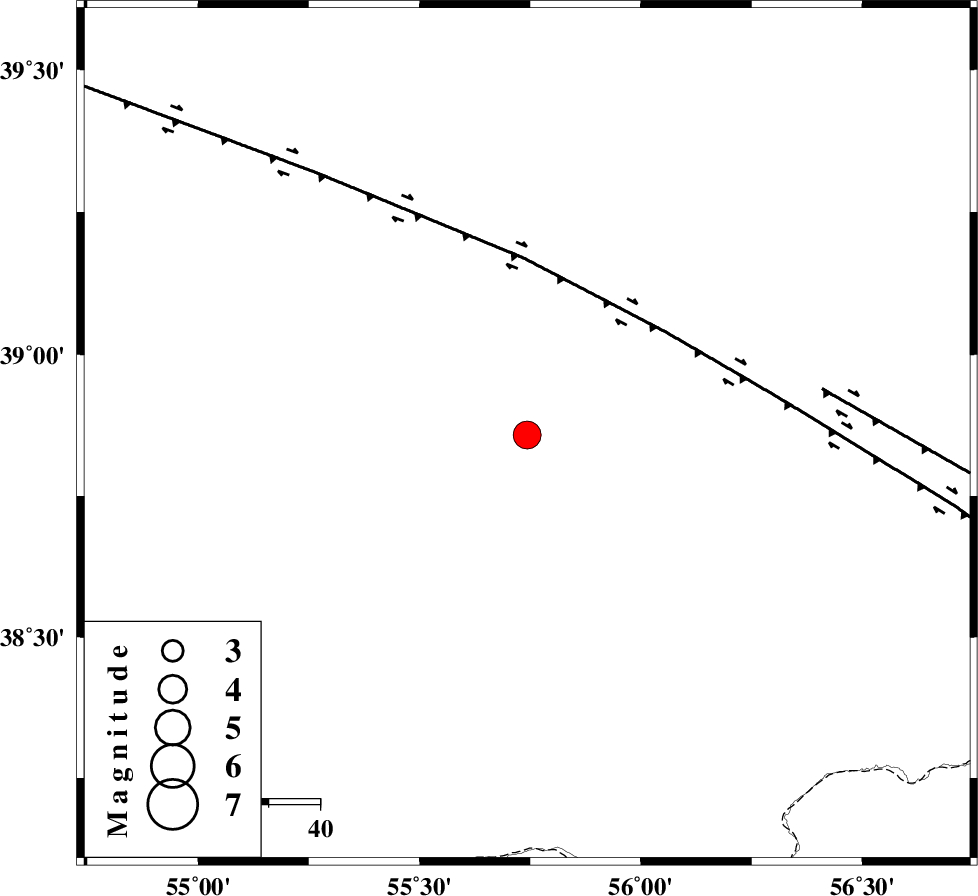
| Location | Lat:38.858 Lon: 55.743 |
| Region | Turkmenistan |
Nearest Cities |
|
| 102 km North East of Karand, Golestan Province | |
| 108 km North West of Moravehtappeh, Golestan Province | |
| 114 km North West of Yekehsoud-e paeen, Khorasan(north) Province | |
| 114 km North West of Qazanqayeh, Golestan Province | |
| 123 km North East of Qareh aghaj, Golestan Province | |
| Depth | 12 km |
| Agency | |
Faults within 150 km: |
|
| MAIN_KOPEHDAGH_F1 (Length: 318 km) , Distance to epicenter: 34 km | |
| MAIN_KOPEHDAGH_F2 (Length: 131 km) , Distance to epicenter: 58 km | |
| Number of Phases | 7 |
| RMS | 0.3 |
| Number of Stations | 7 |
| Error in Latitude | >5.5 km |
| Error in Longitude | 5.5 km |
| Error in Depth | 501.9 km |
Download waveform in seisan format
to download seisan software Click here
to access information about IIEES stations Click here
Amplitude | ||||||||
| UID | Agency | Station | Component | Amplitude | Period | Arrival Time | Proccessing Time | Signal Clip |
| 201549 | IIEES SC | SFB | Z | 0.09 | 1 | 2026-02-15 08:03:37 | 2026-02-21 09:51:00 | n |
| 201550 | IIEES SC | KRVR | Z | 0.04 | 1 | 2026-02-15 08:04:04 | 2026-02-21 09:51:00 | n |
Phase | ||||||||||||
| Agency | Station | Component | Phase Type | Phase Quality | First Motion | Observed Arrival Time | Time Residual | Loc. Flag | Input Weight | Distance | Azimuth | |
| IIEES SC | SFB | Z | EPn | E | 2026-02-15 08:03:37 | -0.1 | y | 0 | 590 | 212 | ||
| IIEES SC | KOO | Z | EPn | E | 2026-02-15 08:03:59 | -0.3 | y | 0 | 773 | 158 | ||
| IIEES SC | KRVR | Z | EPn | E | 2026-02-15 08:04:04 | 0.2 | y | 0 | 806 | 173 | ||
| IIEES SC | HNVD | Z | EPn | E | 2026-02-15 08:04:08 | -0.2 | y | 0 | 838 | 233 | ||
| IIEES SC | BRJ | Z | EPn | E | 2026-02-15 08:04:13 | 0.8 | y | 0 | 872 | 208 | ||
| IIEES SC | GNI | Z | EPn | E | 2026-02-15 08:04:23 | 0.1 | y | 0 | 957 | 279 | ||
| IIEES SC | KIV | Z | EPn | E | 2026-02-15 08:04:52 | -4.3 | n | 4 | 1230 | 297 | ||