
Magnitude |
:3.1 |
| Date & Time (UTC) | 2026-02-01 06:41:05.5 |
| Date & Time (Local) | 1404/11/12 10:11:05.5 |
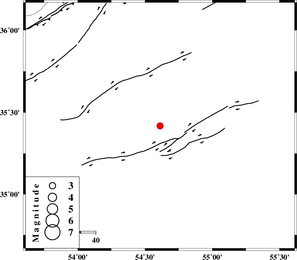
| Location | Lat:35.418 Lon: 54.612 |
| Region | Semnan Province, 86 km South-East of Damghan |
Nearest Cities |
|
| 80 km South East of Amirabad, Semnan Province | |
| 82 km South East of Seydabad, Semnan Province | |
| 86 km South East of Damghan, Semnan Province | |
| 89 km South of Mehmandust, Semnan Province | |
| 90 km South East of Darvar, Semnan Province | |
| Depth | 12 km |
| Agency | |
Faults within 150 km: |
|
| TORUD_F (Length: 136 km) , Distance to epicenter: 11 km | |
| MEYAMEY_F (Length: 141 km) , Distance to epicenter: 83 km | |
| ATARI_F (Length: 185 km) , Distance to epicenter: 87 km | |
| Number of Phases | 9 |
| RMS | 0.6 |
| Number of Stations | 9 |
| Error in Latitude | >3.4 km |
| Error in Longitude | 3.4 km |
| Error in Depth | 23.6 km |
Download waveform in seisan format
to download seisan software Click here
to access information about IIEES stations Click here
Amplitude | ||||||||
| UID | Agency | Station | Component | Amplitude | Period | Arrival Time | Proccessing Time | Signal Clip |
| 201324 | IIEES SC | TABS | Z | 0.1 | 1 | 2026-02-01 06:41:51 | 2026-02-02 08:05:00 | n |
| 201325 | IIEES SC | CHTH | Z | 0.09 | 1 | 2026-02-01 06:41:54 | 2026-02-02 08:05:00 | n |
| 201326 | IIEES SC | YZKH | Z | 0.09 | 1 | 2026-02-01 06:41:54 | 2026-02-02 08:05:00 | n |
| 201327 | IIEES SC | SHRT | Z | 0.02 | 1 | 2026-02-01 06:42:22 | 2026-02-02 08:05:00 | n |
Phase | ||||||||||||
| Agency | Station | Component | Phase Type | Phase Quality | First Motion | Observed Arrival Time | Time Residual | Loc. Flag | Input Weight | Distance | Azimuth | |
| IIEES SC | ABGH | Z | EPg | E | 2026-02-01 06:41:29 | 0 | y | 0 | 147 | 7 | ||
| IIEES SC | SFB | Z | EPn | E | 2026-02-01 06:41:43 | -0.8 | y | 0 | 247 | 241 | ||
| IIEES SC | TABS | Z | EPn | E | 2026-02-01 06:41:51 | 0.7 | y | 0 | 302 | 130 | ||
| IIEES SC | CHTH | Z | EPn | E | 2026-02-01 06:41:54 | 0.6 | y | 0 | 320 | 280 | ||
| IIEES SC | NASN | Z | EPn | E | 2026-02-01 06:41:55 | 0.7 | y | 0 | 335 | 210 | ||
| IIEES SC | YZKH | Z | EPn | E | 2026-02-01 06:41:54 | -0.7 | y | 0 | 336 | 180 | ||
| IIEES SC | BJRD | Z | EPn | E | 2026-02-01 06:41:57 | 0.2 | y | 0 | 356 | 45 | ||
| IIEES SC | ASAO | Z | EPn | E | 2026-02-01 06:42:06 | -0.5 | y | 0 | 430 | 257 | ||
| IIEES SC | SHRT | Z | EPn | E | 2026-02-01 06:42:22 | -0.5 | y | 0 | 557 | 111 | ||