
Magnitude |
:3.3 |
| Date & Time (UTC) | 2026-01-28 04:41:07.9 |
| Date & Time (Local) | 1404/11/8 08:11:07.9 |
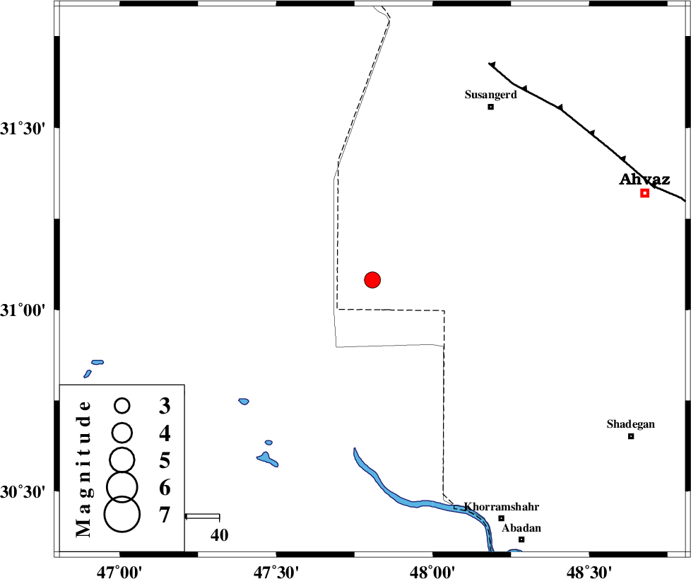
| Location | Lat:31.082 Lon: 47.807 |
| Region | Khoozestan Province, 62 km North of Al Basrah |
Nearest Cities |
|
| 49 km South West of Hoveizeh, Khoozestan Province | |
| 62 km North of Al Basrah, Iraq Province | |
| 64 km South West of Susangerd, Khoozestan Province | |
| 66 km South West of Jalaliyeh, Khoozestan Province | |
| 70 km North West of Darkhovin, Khoozestan Province | |
| Depth | 12 km |
| Agency | |
Faults within 150 km: |
|
| AHVAZ_F (Length: 99 km) , Distance to epicenter: 73 km | |
| AGHAJARI_F (Length: 88 km) , Distance to epicenter: 136 km | |
| Number of Phases | 10 |
| RMS | 0.3 |
| Number of Stations | 10 |
| Error in Latitude | >4.6 km |
| Error in Longitude | 4.6 km |
| Error in Depth | 12 km |
Download waveform in seisan format
to download seisan software Click here
to access information about IIEES stations Click here
Amplitude | ||||||||
| UID | Agency | Station | Component | Amplitude | Period | Arrival Time | Proccessing Time | Signal Clip |
| 201266 | IIEES SC | AMS1 | Z | 0.6 | 1 | 2026-01-28 04:41:37 | 2026-01-28 09:02:00 | n |
| 201267 | IIEES SC | ABH1 | Z | 0.5 | 1 | 2026-01-28 04:41:45 | 2026-01-28 09:02:00 | n |
| 201268 | IIEES SC | ASAO | Z | 0.05 | 1 | 2026-01-28 04:42:10 | 2026-01-28 09:02:00 | n |
| 201269 | IIEES SC | SRSL | Z | 0.03 | 1 | 2026-01-28 04:42:31 | 2026-01-28 09:02:00 | n |
Phase | ||||||||||||
| Agency | Station | Component | Phase Type | Phase Quality | First Motion | Observed Arrival Time | Time Residual | Loc. Flag | Input Weight | Distance | Azimuth | |
| IIEES SC | AMS1 | Z | EPg | E | 2026-01-28 04:41:37 | -0.2 | y | 0 | 183 | 54 | ||
| IIEES SC | AMS1 | Z | ESg | E | 2026-01-28 04:42:01 | 1.8 | n | 4 | 183 | 54 | ||
| IIEES SC | ABH1 | Z | EPn | E | 2026-01-28 04:41:45 | 0.1 | y | 0 | 240 | 103 | ||
| IIEES SC | HNVD | Z | EPn | E | 2026-01-28 04:42:01 | 0.5 | y | 0 | 361 | 7 | ||
| IIEES SC | ASAO | Z | EPn | E | 2026-01-28 04:42:10 | 0.3 | y | 0 | 437 | 28 | ||
| IIEES SC | GHVR | Z | EPn | E | 2026-01-28 04:42:17 | 0.1 | y | 0 | 496 | 41 | ||
| IIEES SC | NASN | Z | EPn | E | 2026-01-28 04:42:19 | -0.3 | y | 0 | 510 | 68 | ||
| IIEES SC | GHIR | Z | EPn | E | 2026-01-28 04:42:23 | -5.6 | n | 4 | 590 | 122 | ||
| IIEES SC | SRSL | Z | EPn | E | 2026-01-28 04:42:31 | -0.4 | y | 0 | 610 | 339 | ||
| IIEES SC | TABS | Z | EPn | E | 2026-01-28 04:43:09 | -0.5 | y | 0 | 922 | 72 | ||