
Magnitude |
:3.5 |
| Date & Time (UTC) | 2026-01-13 18:16:20.0 |
| Date & Time (Local) | 1404/10/23 21:46:20.0 |
| Location | Lat:31.782 Lon: 56.071 |
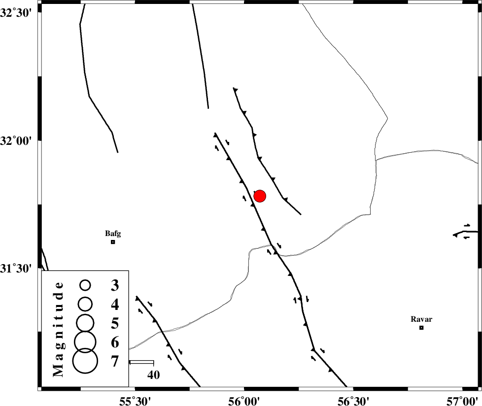
| Region | Yazd Province, 67 km North-East of Bafq |
Nearest Cities |
|
| 5 km North of Benestan, Yazd Province | |
| 11 km of Behabad, Yazd Province | |
| 19 km North West of Asfih, Yazd Province | |
| 27 km North East of Kushk, Yazd Province | |
| 35 km North of Basab, Yazd Province | |
| Depth | 12 km |
| Agency | |
Faults within 150 km: |
|
| KUHBANAN_F (Length: 189 km) , Distance to epicenter: 7 km | |
| JAFARABAD_F (Length: 60 km) , Distance to epicenter: 9 km | |
| SARBALA_F (Length: 92 km) , Distance to epicenter: 44 km | |
| Number of Phases | 4 |
| RMS | 0.2 |
| Number of Stations | 4 |
| Error in Latitude | >31.8 km |
| Error in Longitude | 56.1 km |
| Error in Depth | 12 km |
Download waveform in seisan format
to download seisan software Click here
to access information about IIEES stations Click here
Amplitude | ||||||||
| UID | Agency | Station | Component | Amplitude | Period | Arrival Time | Proccessing Time | Signal Clip |
| 201096 | IIEES SC | KRVR | Z | 1 | 1 | 2026-01-13 18:16:33 | 2026-01-14 07:39:00 | n |
| 201097 | IIEES SC | YZKH | Z | 2 | 1 | 2026-01-13 18:16:45 | 2026-01-14 07:39:00 | n |
| 201098 | IIEES SC | KRBR | Z | 3 | 1 | 2026-01-13 18:16:54 | 2026-01-14 07:39:00 | n |
Phase | ||||||||||||
| Agency | Station | Component | Phase Type | Phase Quality | First Motion | Observed Arrival Time | Time Residual | Loc. Flag | Input Weight | Distance | Azimuth | |
| IIEES SC | KRVR | Z | EPg | E | 2026-01-13 18:16:33 | 0 | y | 0 | 76 | 101 | ||
| IIEES SC | YZKH | Z | EPg | E | 2026-01-13 18:16:45 | -0.3 | y | 0 | 155 | 296 | ||
| IIEES SC | KRBR | Z | EPn | E | 2026-01-13 18:16:54 | 0 | y | 0 | 210 | 162 | ||
| IIEES SC | QABG | Z | EPn | E | 2026-01-13 18:18:01 | 0.7 | y | 0 | 742 | 306 | ||