
Magnitude |
:3.4 |
| Date & Time (UTC) | 2025-12-21 01:35:14.1 |
| Date & Time (Local) | 1404/9/30 05:05:14.1 |
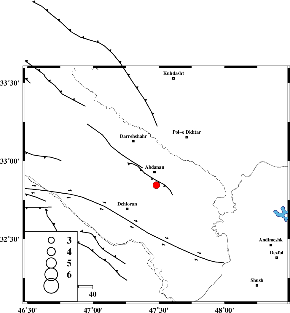
| Location | Lat:32.845 Lon: 47.481 |
| Region | Ilam Province, 10 km of Abdanan |
Nearest Cities |
|
| 10 km of Abdanan, Ilam Province | |
| 10 km of Sarabbagh, Ilam Province | |
| 27 km North East of Dehloran, Ilam Province | |
| 34 km South West of Sarab hammam, Lorestan Province | |
| 35 km North East of Musian, Ilam Province | |
| Depth | 12 km |
| Agency | |
Faults within 150 km: |
|
| MFF6 (Length: 144 km) , Distance to epicenter: 16 km | |
| BALARUD_F_Z1 (Length: 87 km) , Distance to epicenter: 25 km | |
| BALARUD_F_Z3 (Length: 53 km) , Distance to epicenter: 54 km | |
| Number of Phases | 6 |
| RMS | 0.5 |
| Number of Stations | 6 |
| Error in Latitude | >18 km |
| Error in Longitude | 18 km |
| Error in Depth | 999 km |
Download waveform in seisan format
to download seisan software Click here
to access information about IIEES stations Click here
Amplitude | ||||||||
| UID | Agency | Station | Component | Amplitude | Period | Arrival Time | Proccessing Time | Signal Clip |
| 200678 | IIEES SC | GHVR | Z | 0.1 | 1 | 2025-12-21 01:36:11 | 2025-12-21 07:59:00 | n |
| 200679 | IIEES SC | SRSL | Z | 0.06 | 1 | 2025-12-21 01:36:14 | 2025-12-21 07:59:00 | n |
Phase | ||||||||||||
| Agency | Station | Component | Phase Type | Phase Quality | First Motion | Observed Arrival Time | Time Residual | Loc. Flag | Input Weight | Distance | Azimuth | |
| IIEES SC | GHVR | Z | EPn | E | 2025-12-21 01:36:11 | 0.6 | y | 0 | 393 | 63 | ||
| IIEES SC | SRSL | Z | EPn | E | 2025-12-21 01:36:14 | 0.4 | y | 0 | 418 | 333 | ||
| IIEES SC | NASN | Z | EPn | E | 2025-12-21 01:36:30 | 6.3 | n | 4 | 499 | 91 | ||
| IIEES SC | YZKH | Z | EPn | E | 2025-12-21 01:36:45 | 0 | y | 0 | 669 | 94 | ||
| IIEES SC | ABGH | Z | EPn | E | 2025-12-21 01:37:00 | -0.8 | y | 0 | 797 | 57 | ||
| IIEES SC | GURO | Z | EPn | E | 2025-12-21 01:37:01 | -0.6 | y | 0 | 802 | 322 | ||