
Magnitude |
:3.1 |
| Date & Time (UTC) | 2025-12-14 20:55:55.5 |
| Date & Time (Local) | 1404/9/24 00:25:55.5 |
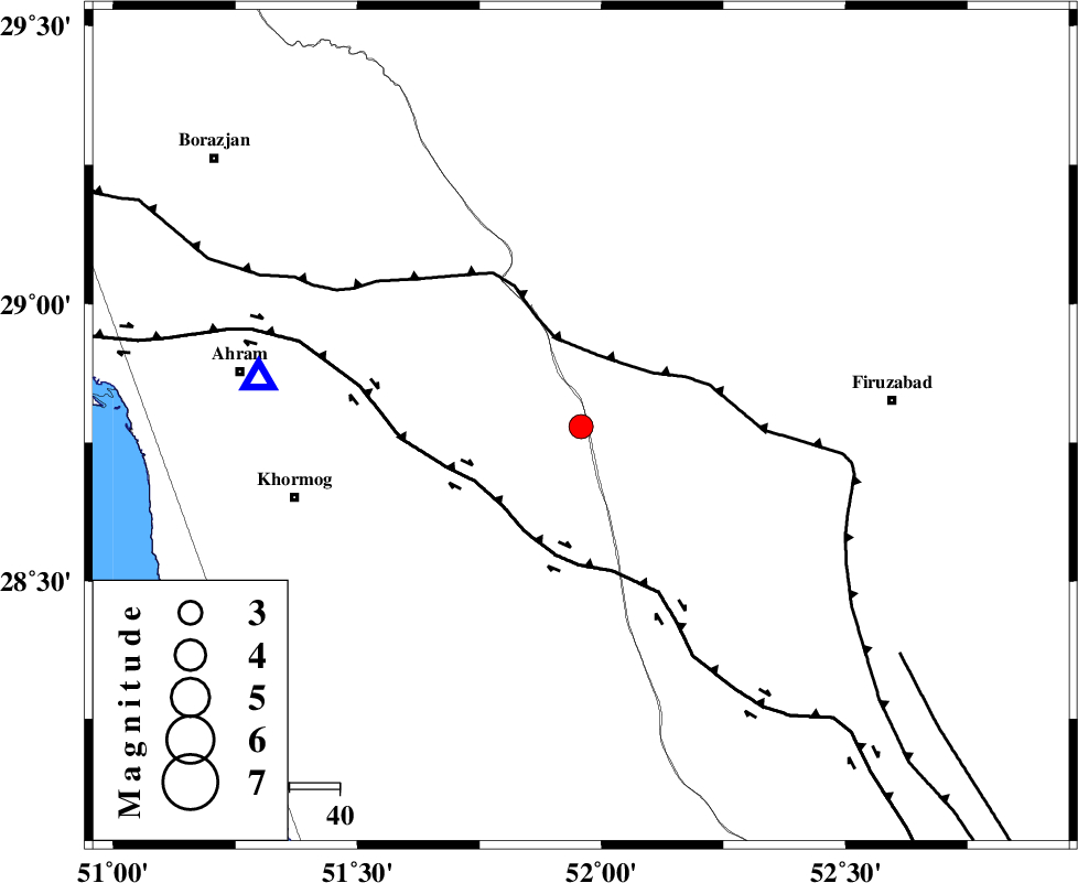
| Location | Lat:28.779 Lon: 51.958 |
| Region | Bushehr Province, 16 km -West of Farashband |
Nearest Cities |
|
| 16 km West of Farashband, Fars Province | |
| 18 km South of Aviz, Fars Province | |
| 37 km South of Nujin, Fars Province | |
| 46 km South West of Dadanjan, Fars Province | |
| 47 km North West of Dahrom, Fars Province | |
| Depth | 12 km |
| Agency | |
Faults within 150 km: |
|
| KAREBASS_F (Length: 98 km) , Distance to epicenter: 34 km | |
| QIR_F (Length: 130 km) , Distance to epicenter: 38 km | |
| MFF5 (Length: 74 km) , Distance to epicenter: 39 km | |
| Number of Phases | 9 |
| RMS | 0.4 |
| Number of Stations | 9 |
| Error in Latitude | >2.4 km |
| Error in Longitude | 2.4 km |
| Error in Depth | 9.8 km |
Download waveform in seisan format
to download seisan software Click here
to access information about IIEES stations Click here
Amplitude | ||||||||
| UID | Agency | Station | Component | Amplitude | Period | Arrival Time | Proccessing Time | Signal Clip |
| 200583 | IIEES SC | NASN | Z | 0.02 | 1 | 2025-12-14 20:57:00 | 2025-12-15 08:36:00 | n |
| 200584 | IIEES SC | YZKH | Z | 0.05 | 1 | 2025-12-14 20:57:02 | 2025-12-15 08:36:00 | n |
| 200585 | IIEES SC | UOSS | Z | 0.02 | 1 | 2025-12-14 20:57:17 | 2025-12-15 08:36:00 | n |
Phase | ||||||||||||
| Agency | Station | Component | Phase Type | Phase Quality | First Motion | Observed Arrival Time | Time Residual | Loc. Flag | Input Weight | Distance | Azimuth | |
| IIEES SC | AHRM | Z | EPg | E | 2025-12-14 20:56:06 | 0 | y | 0 | 65 | 278 | ||
| IIEES SC | GHIR | Z | EPg | E | 2025-12-14 20:56:15 | 0.8 | y | 0 | 115 | 119 | ||
| IIEES SC | NASN | Z | EPn | E | 2025-12-14 20:57:00 | 0.4 | y | 0 | 453 | 10 | ||
| IIEES SC | YZKH | Z | EPn | E | 2025-12-14 20:57:02 | 0.2 | y | 0 | 473 | 32 | ||
| IIEES SC | KRBR | Z | EPn | E | 2025-12-14 20:57:03 | -0.6 | y | 0 | 485 | 74 | ||
| IIEES SC | UOSS | Z | EPn | E | 2025-12-14 20:57:17 | -0.6 | y | 0 | 599 | 135 | ||
| IIEES SC | GHVR | Z | EPn | E | 2025-12-14 20:57:22 | 0 | y | 0 | 636 | 354 | ||
| IIEES SC | TABS | Z | EPn | E | 2025-12-14 20:57:11 | -22.3 | n | 4 | 730 | 42 | ||
| IIEES SC | SHRO | Z | EPn | E | 2025-12-14 20:57:53 | -0.3 | y | 0 | 888 | 25 | ||