
Magnitude |
:3.4 |
| Date & Time (UTC) | 2025-11-09 03:22:16.4 |
| Date & Time (Local) | 1404/8/18 06:52:16.4 |
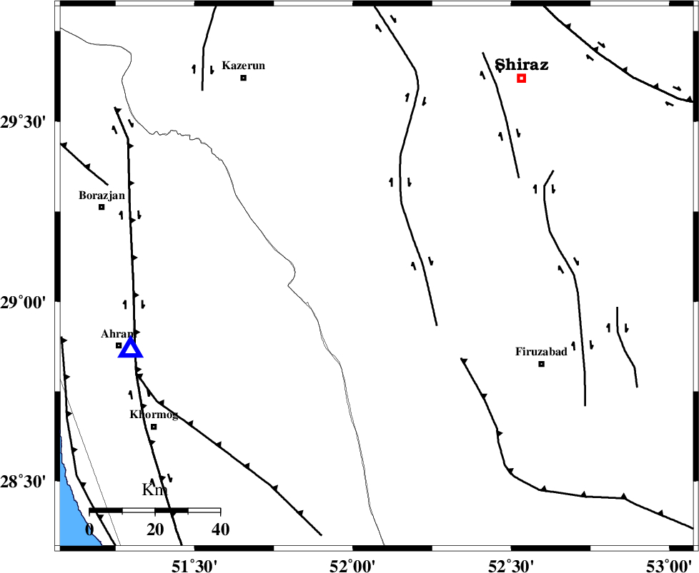
| Location | Lat:29.069 Lon: 52.075 |
| Region | Fars Province, 22 km North of Farashband |
Nearest Cities |
|
| 8 km of Nujin, Fars Province | |
| 16 km West of Dadanjan, Fars Province | |
| 17 km North of Aviz, Fars Province | |
| 21 km South of Jareh, Fars Province | |
| 22 km North of Farashband, Fars Province | |
| Depth | 10 km |
| Agency | |
Faults within 150 km: |
|
| KAREBASS_F (Length: 98 km) , Distance to epicenter: 15 km | |
| QIR_F (Length: 130 km) , Distance to epicenter: 36 km | |
| SABZ_PUSHAN_F_Z3 (Length: 37 km) , Distance to epicenter: 53 km | |
| Number of Phases | 8 |
| RMS | 0.4 |
| Number of Stations | 8 |
| Error in Latitude | >4.5 km |
| Error in Longitude | 4.5 km |
| Error in Depth | 16.7 km |
Download waveform in seisan format
to download seisan software Click here
to access information about IIEES stations Click here
Amplitude | ||||||||
| UID | Agency | Station | Component | Amplitude | Period | Arrival Time | Proccessing Time | Signal Clip |
| 200015 | IIEES SC | KRBR | Z | 0.07 | 1 | 2025-11-09 03:23:22 | 2025-11-10 08:31:00 | n |
| 200016 | IIEES SC | UOSS | Z | 0.03 | 1 | 2025-11-09 03:23:41 | 2025-11-10 08:31:00 | n |
| 200017 | IIEES SC | ASAO | Z | 0.02 | 1 | 2025-11-09 03:23:44 | 2025-11-10 08:31:00 | n |
| 200018 | IIEES SC | TABS | Z | 0.02 | 1 | 2025-11-09 03:23:50 | 2025-11-10 08:31:00 | n |
Phase | ||||||||||||
| Agency | Station | Component | Phase Type | Phase Quality | First Motion | Observed Arrival Time | Time Residual | Loc. Flag | Input Weight | Distance | Azimuth | |
| IIEES SC | GHIR | Z | EPg | E | 2025-11-09 03:22:37 | -0.3 | y | 0 | 124 | 134 | ||
| IIEES SC | MEH | Z | EPn | E | 2025-11-09 03:23:09 | 0.9 | y | 0 | 355 | 44 | ||
| IIEES SC | YZKH | Z | EPn | E | 2025-11-09 03:22:57 | -21.8 | n | 4 | 440 | 33 | ||
| IIEES SC | KRBR | Z | EPn | E | 2025-11-09 03:23:22 | -0.1 | y | 0 | 465 | 77 | ||
| IIEES SC | GHVR | Z | EPn | E | 2025-11-09 03:23:39 | -0.1 | y | 0 | 605 | 353 | ||
| IIEES SC | UOSS | Z | EPn | E | 2025-11-09 03:23:41 | 0.3 | y | 0 | 614 | 138 | ||
| IIEES SC | ASAO | Z | EPn | E | 2025-11-09 03:23:44 | 0 | y | 0 | 638 | 342 | ||
| IIEES SC | TABS | Z | EPn | E | 2025-11-09 03:23:50 | -0.7 | y | 0 | 699 | 43 | ||