
Magnitude |
:3.3 |
| Date & Time (UTC) | 2025-11-04 18:10:58.7 |
| Date & Time (Local) | 1404/8/13 21:40:58.7 |
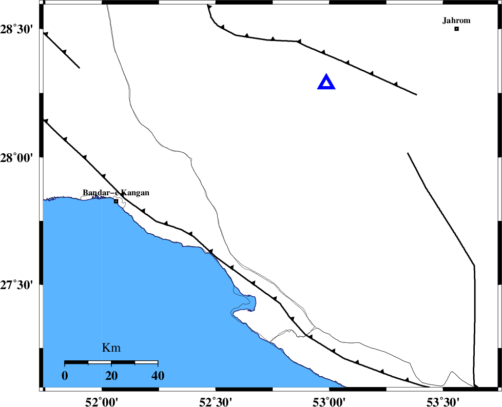
| Location | Lat:27.846 Lon: 52.741 |
| Region | Fars Province, 42 km -East of Jam |
Nearest Cities |
|
| 15 km North of Asir, Fars Province | |
| 18 km South of Garmesht, Fars Province | |
| 22 km North of Gallehdar, Fars Province | |
| 30 km North of Ardavan-e olia, Fars Province | |
| 33 km North West of Alamarvdasht, Fars Province | |
| Depth | 12 km |
| Agency | |
Faults within 150 km: |
|
| MFF3 (Length: 292 km) , Distance to epicenter: 35 km | |
| QIR_F (Length: 130 km) , Distance to epicenter: 66 km | |
| SABZ_PUSHAN_F_Z1 (Length: 69 km) , Distance to epicenter: 96 km | |
| Number of Phases | 6 |
| RMS | 0.3 |
| Number of Stations | 6 |
| Error in Latitude | >2.5 km |
| Error in Longitude | 2.5 km |
| Error in Depth | 1.7 km |
Download waveform in seisan format
to download seisan software Click here
to access information about IIEES stations Click here
Amplitude | ||||||||
| UID | Agency | Station | Component | Amplitude | Period | Arrival Time | Proccessing Time | Signal Clip |
| 199963 | IIEES SC | UOSS | Z | 0.04 | 1 | 2025-11-04 18:12:05 | 2025-11-05 07:16:00 | n |
| 199964 | IIEES SC | IRSR | Z | 0.007 | 1 | 2025-11-04 18:12:47 | 2025-11-05 07:16:00 | n |
Phase | ||||||||||||
| Agency | Station | Component | Phase Type | Phase Quality | First Motion | Observed Arrival Time | Time Residual | Loc. Flag | Input Weight | Distance | Azimuth | |
| IIEES SC | GHIR | Z | EPg | E | 2025-11-04 18:11:07 | -0.8 | y | 0 | 54 | 26 | ||
| IIEES SC | MEH | Z | EPn | E | 2025-11-04 18:12:00 | 0.4 | y | 0 | 433 | 25 | ||
| IIEES SC | KRBR | Z | EPn | E | 2025-11-04 18:12:03 | 0.1 | y | 0 | 458 | 59 | ||
| IIEES SC | UOSS | Z | EPn | E | 2025-11-04 18:12:05 | 0.1 | y | 0 | 472 | 133 | ||
| IIEES SC | TABS | Z | EPn | E | 2025-11-04 18:12:42 | 0 | y | 0 | 768 | 33 | ||
| IIEES SC | IRSR | Z | EPn | E | 2025-11-04 18:12:47 | 0 | y | 0 | 809 | 97 | ||