
Magnitude |
:3.4 |
| Date & Time (UTC) | 2025-10-30 15:30:37.5 |
| Date & Time (Local) | 1404/8/8 19:00:37.5 |
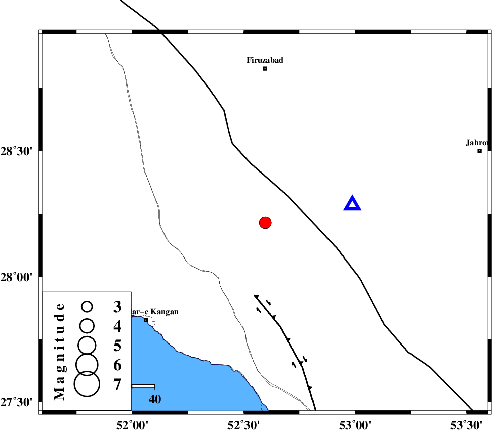
| Location | Lat:28.215 Lon: 52.596 |
| Region | Fars Province, 68 km South of Firuz Abad |
Nearest Cities |
|
| 18 km South of Hengam, Fars Province | |
| 27 km North West of Garmesht, Fars Province | |
| 31 km North East of Dolatabad, Fars Province | |
| 42 km South East of Dahrom, Fars Province | |
| 51 km North East of Jam, Bushehr Province | |
| Depth | 17 km |
| Agency | |
Faults within 150 km: |
|
| QIR_F (Length: 130 km) , Distance to epicenter: 29 km | |
| SABZ_PUSHAN_F_Z1 (Length: 69 km) , Distance to epicenter: 57 km | |
| MFF3 (Length: 292 km) , Distance to epicenter: 61 km | |
| Number of Phases | 6 |
| RMS | 0.4 |
| Number of Stations | 6 |
| Error in Latitude | >5.4 km |
| Error in Longitude | 5.4 km |
| Error in Depth | 6.2 km |
Download waveform in seisan format
to download seisan software Click here
to access information about IIEES stations Click here
Amplitude | ||||||||
| UID | Agency | Station | Component | Amplitude | Period | Arrival Time | Proccessing Time | Signal Clip |
| 199890 | IIEES SC | KRBR | Z | 0.06 | 1 | 2025-10-30 15:31:40 | 2025-11-01 05:15:00 | n |
| 199891 | IIEES SC | UOSS | Z | 0.04 | 1 | 2025-10-30 15:31:48 | 2025-11-01 05:15:00 | n |
| 199892 | IIEES SC | ASAO | Z | 0.02 | 1 | 2025-10-30 15:32:17 | 2025-11-01 05:15:00 | n |
| 199893 | IIEES SC | IRSR | Z | 0.007 | 1 | 2025-10-30 15:32:28 | 2025-11-01 05:15:00 | n |
Phase | ||||||||||||
| Agency | Station | Component | Phase Type | Phase Quality | First Motion | Observed Arrival Time | Time Residual | Loc. Flag | Input Weight | Distance | Azimuth | |
| IIEES SC | GHIR | Z | EPg | E | 2025-10-30 15:30:44 | -0.1 | y | 0 | 39 | 79 | ||
| IIEES SC | KRBR | Z | EPn | E | 2025-10-30 15:31:40 | -0.3 | y | 0 | 450 | 64 | ||
| IIEES SC | UOSS | Z | EPn | E | 2025-10-30 15:31:48 | -0.1 | y | 0 | 510 | 135 | ||
| IIEES SC | ASAO | Z | EPn | E | 2025-10-30 15:32:17 | 0.4 | y | 0 | 743 | 341 | ||
| IIEES SC | IRSR | Z | EPn | E | 2025-10-30 15:32:28 | 0.5 | y | 0 | 828 | 100 | ||
| IIEES SC | SRSL | Z | EPn | E | 2025-10-30 15:33:02 | -0.6 | y | 0 | 1114 | 323 | ||