
Magnitude |
:3.5 |
| Date & Time (UTC) | 2025-10-23 08:58:07.9 |
| Date & Time (Local) | 1404/8/1 12:28:07.9 |
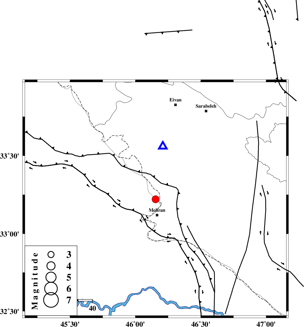
| Location | Lat:33.221 Lon: 46.154 |
| Region | Iraq, 11 km North of Mehran |
Nearest Cities |
|
| 11 km North of Mehran, Ilam Province | |
| 28 km South of Salehabad, Ilam Province | |
| 29 km South West of Galeh-yedarre-hemalakshahi, Ilam Province | |
| 37 km West of Gonbad-e pirmohammad, Ilam Province | |
| 38 km South West of Mehr, Ilam Province | |
| Depth | 12 km |
| Agency | |
Faults within 150 km: |
|
| ZFF4 (Length: 128 km) , Distance to epicenter: 3 km | |
| MFF6 (Length: 144 km) , Distance to epicenter: 18 km | |
| MFF7 (Length: 99 km) , Distance to epicenter: 31 km | |
| Number of Phases | 6 |
| RMS | 0.1 |
| Number of Stations | 6 |
| Error in Latitude | >1.5 km |
| Error in Longitude | 1.5 km |
| Error in Depth | 211.8 km |
Download waveform in seisan format
to download seisan software Click here
to access information about IIEES stations Click here
Amplitude | ||||||||
| UID | Agency | Station | Component | Amplitude | Period | Arrival Time | Proccessing Time | Signal Clip |
| 199824 | IIEES SC | ASAO | Z | 0.1 | 1 | 2025-10-23 08:59:04 | 2025-10-26 04:53:00 | n |
| 199825 | IIEES SC | CHTH | Z | 0.05 | 1 | 2025-10-23 08:59:23 | 2025-10-26 04:53:00 | n |
Phase | ||||||||||||
| Agency | Station | Component | Phase Type | Phase Quality | First Motion | Observed Arrival Time | Time Residual | Loc. Flag | Input Weight | Distance | Azimuth | |
| IIEES SC | SRSL | Z | EPn | E | 2025-10-23 08:58:58 | 0 | y | 0 | 338 | 349 | ||
| IIEES SC | BSR2 | Z | EPn | E | 2025-10-23 08:58:59 | 0 | y | 0 | 353 | 157 | ||
| IIEES SC | ASAO | Z | EPn | E | 2025-10-23 08:59:04 | -0.2 | y | 0 | 387 | 68 | ||
| IIEES SC | GHVR | Z | EPn | E | 2025-10-23 08:59:17 | 0.1 | y | 0 | 492 | 74 | ||
| IIEES SC | CHTH | Z | EPn | E | 2025-10-23 08:59:23 | 0 | y | 0 | 545 | 57 | ||
| IIEES SC | DAMV | Z | EPn | E | 2025-10-23 08:59:16 | -14 | n | 4 | 598 | 63 | ||