
Magnitude |
:3.5 |
| Date & Time (UTC) | 2025-10-13 21:30:08.1 |
| Date & Time (Local) | 1404/7/22 01:00:08.1 |
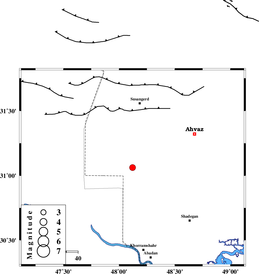
| Location | Lat:31.062 Lon: 48.121 |
| Region | Khoozestan Province, 55 km South of Susangerd |
Nearest Cities |
|
| 43 km South West of Bahr, Khoozestan Province | |
| 45 km South of Hoveizeh, Khoozestan Province | |
| 46 km North West of Darkhovin, Khoozestan Province | |
| 47 km West of Abunangeh, Khoozestan Province | |
| 54 km South West of Jalaliyeh, Khoozestan Province | |
| Depth | 16 km |
| Agency | |
Faults within 150 km: |
|
| AHVAZ_F (Length: 99 km) , Distance to epicenter: 60 km | |
| AGHAJARI_F (Length: 88 km) , Distance to epicenter: 107 km | |
| DEZFUL_EMBAYMENT (Length: 228 km) , Distance to epicenter: 143 km | |
| Number of Phases | 8 |
| RMS | 0.1 |
| Number of Stations | 8 |
| Error in Latitude | >0.6 km |
| Error in Longitude | 0.6 km |
| Error in Depth | 3.1 km |
Download waveform in seisan format
to download seisan software Click here
to access information about IIEES stations Click here
Amplitude | ||||||||
| UID | Agency | Station | Component | Amplitude | Period | Arrival Time | Proccessing Time | Signal Clip |
| 199620 | IIEES SC | BSR2 | Z | 2 | 1 | 2025-10-13 21:30:24 | 2025-10-14 06:19:00 | n |
| 199621 | IIEES SC | NASN | Z | 0.07 | 1 | 2025-10-13 21:31:15 | 2025-10-14 06:19:00 | n |
| 199622 | IIEES SC | CHTH | Z | 0.03 | 1 | 2025-10-13 21:31:31 | 2025-10-14 06:19:00 | n |
| 199623 | IIEES SC | SRSL | Z | 0.04 | 1 | 2025-10-13 21:31:33 | 2025-10-14 06:19:00 | n |
Phase | ||||||||||||
| Agency | Station | Component | Phase Type | Phase Quality | First Motion | Observed Arrival Time | Time Residual | Loc. Flag | Input Weight | Distance | Azimuth | |
| IIEES SC | BSR2 | Z | EPg | E | 2025-10-13 21:30:24 | 0 | y | 0 | 98 | 209 | ||
| IIEES SC | ASAO | Z | EPn | E | 2025-10-13 21:31:08 | 0.1 | y | 0 | 426 | 25 | ||
| IIEES SC | NASN | Z | EPn | E | 2025-10-13 21:31:15 | 0.1 | y | 0 | 483 | 67 | ||
| IIEES SC | GHIR | Z | EPn | E | 2025-10-13 21:31:25 | 0 | y | 0 | 563 | 123 | ||
| IIEES SC | CHTH | Z | EPn | E | 2025-10-13 21:31:31 | 0.1 | y | 0 | 606 | 27 | ||
| IIEES SC | MEH | Z | EPn | E | 2025-10-13 21:31:32 | -0.1 | y | 0 | 620 | 87 | ||
| IIEES SC | DAMV | Z | EPn | E | 2025-10-13 21:31:29 | -3.7 | n | 4 | 621 | 35 | ||
| IIEES SC | SRSL | Z | EPn | E | 2025-10-13 21:31:33 | -0.1 | y | 0 | 623 | 336 | ||