
Magnitude |
:3.6 |
| Date & Time (UTC) | 2025-10-04 04:33:45.2 |
| Date & Time (Local) | 1404/7/12 08:03:45.2 |
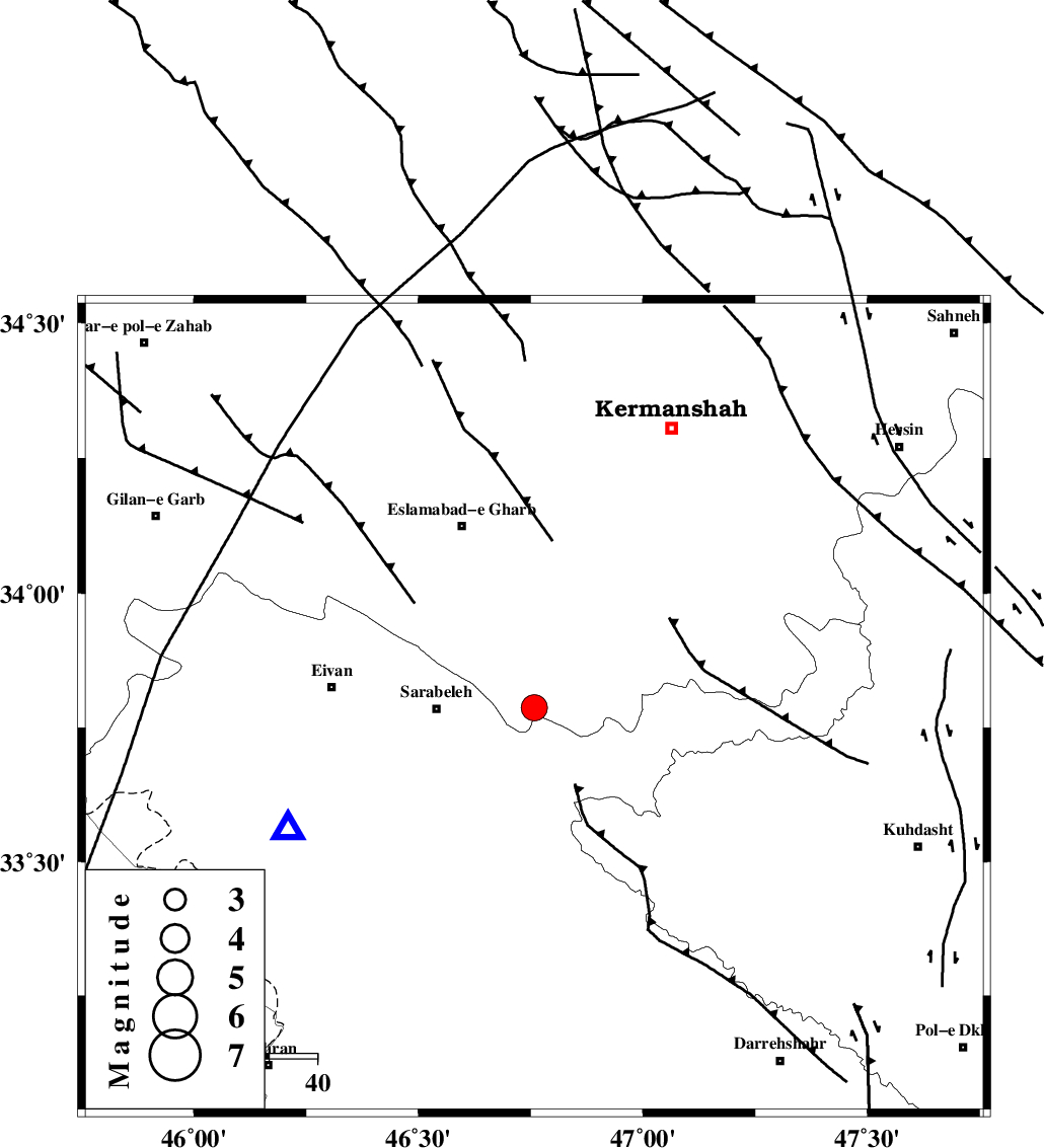
| Location | Lat:33.787 Lon: 46.758 |
| Region | Kermanshah Province, 20 km -East of Sar Ableh |
Nearest Cities |
|
| 11 km of Darbid-e mansuri, Kermanshah Province | |
| 13 km West of Qale-ye harsam, Kermanshah Province | |
| 14 km North of Belaveh tare-e sofla, Ilam Province | |
| 17 km South of Hamil, Kermanshah Province | |
| 17 km North of Sartang-e malehmaran, Ilam Province | |
| Depth | 12 km |
| Agency | |
Faults within 150 km: |
|
| HZF4 (Length: 492 km) , Distance to epicenter: 40 km | |
| MFF7 (Length: 99 km) , Distance to epicenter: 54 km | |
| MFF6 (Length: 144 km) , Distance to epicenter: 72 km | |
| Number of Phases | 7 |
| RMS | 0.3 |
| Number of Stations | 7 |
| Error in Latitude | >4 km |
| Error in Longitude | 4 km |
| Error in Depth | 8.2 km |
Download waveform in seisan format
to download seisan software Click here
to access information about IIEES stations Click here
Amplitude | ||||||||
| UID | Agency | Station | Component | Amplitude | Period | Arrival Time | Proccessing Time | Signal Clip |
| 199481 | IIEES SC | ASAO | Z | 0.3 | 1 | 2025-10-04 04:34:32 | 2025-10-05 05:05:00 | n |
| 199482 | IIEES SC | GURO | Z | 0.04 | 1 | 2025-10-04 04:35:17 | 2025-10-05 05:05:00 | n |
Phase | ||||||||||||
| Agency | Station | Component | Phase Type | Phase Quality | First Motion | Observed Arrival Time | Time Residual | Loc. Flag | Input Weight | Distance | Azimuth | |
| IIEES SC | SRSL | Z | EPn | E | 2025-10-04 04:34:29 | -0.2 | y | 0 | 295 | 336 | ||
| IIEES SC | SRSL | Z | ES | E | 2025-10-04 04:35:02 | -0.1 | y | 0 | 295 | 336 | ||
| IIEES SC | ASAO | Z | EPn | E | 2025-10-04 04:34:32 | 0.4 | y | 0 | 313 | 74 | ||
| IIEES SC | DAMV | Z | EPn | E | 2025-10-04 04:34:44 | -13.1 | n | 4 | 520 | 67 | ||
| IIEES SC | GURO | Z | EPn | E | 2025-10-04 04:35:17 | 0.3 | y | 0 | 678 | 321 | ||
| IIEES SC | GLO | Z | EPn | E | 2025-10-04 04:35:21 | -0.4 | y | 0 | 711 | 65 | ||
| IIEES SC | GHIR | Z | EPn | E | 2025-10-04 04:35:39 | 0 | y | 0 | 852 | 136 | ||