
Magnitude |
:2.9 |
| Date & Time (UTC) | 2025-10-02 14:02:35.3 |
| Date & Time (Local) | 1404/7/10 17:32:35.3 |
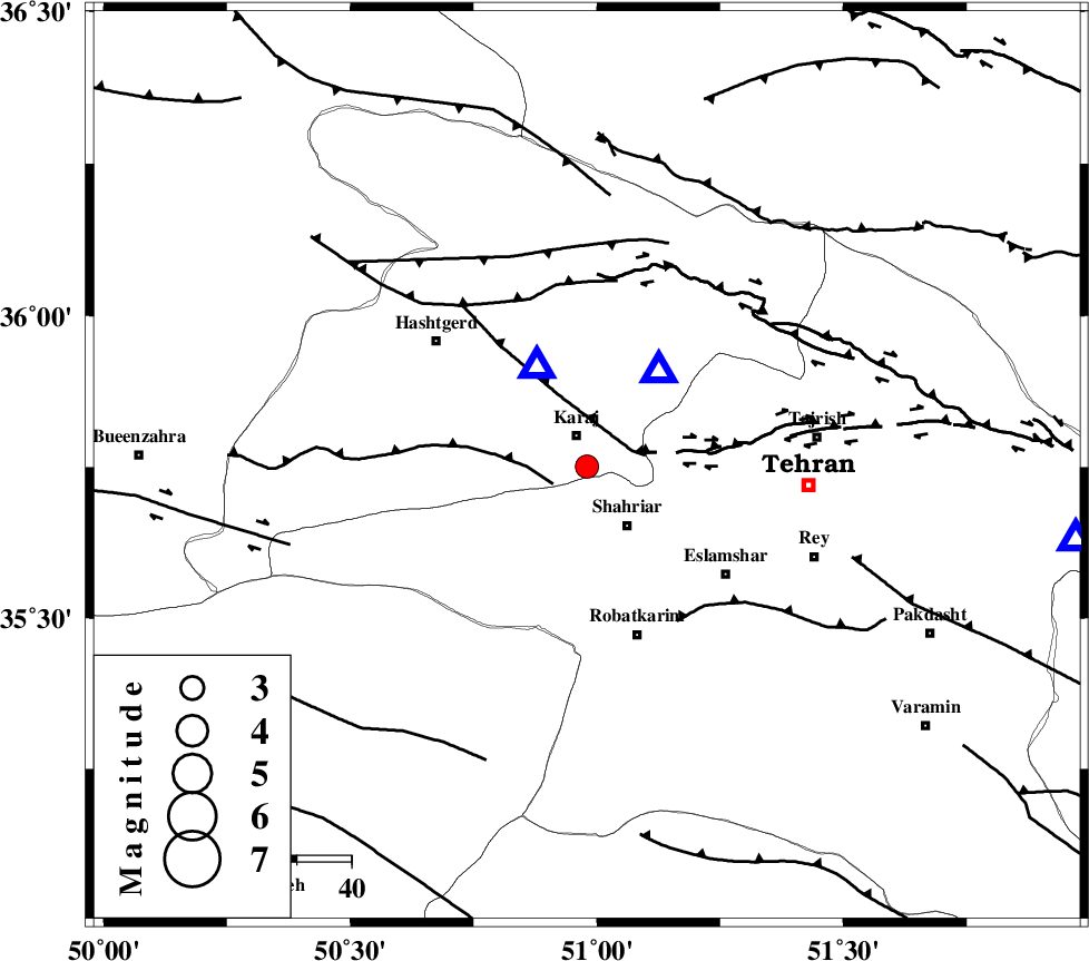
| Location | Lat:35.751 Lon: 50.98 |
| Region | Tehran Province, 6 km of Karaj |
Nearest Cities |
|
| 6 km of Karaj, Tehran Province | |
| 10 km North of Malard, Tehran Province | |
| 13 km North of Shahriyar, Tehran Province | |
| 17 km North of Joqin, Tehran Province | |
| 21 km South of Barghan, Tehran Province | |
| Depth | 12 km |
| Agency | |
Faults within 150 km: |
|
| ESHTEHARD_F (Length: 69 km) , Distance to epicenter: 7 km | |
| N_TEHRAN_F4 (Length: 115 km) , Distance to epicenter: 9 km | |
| MOSHA_F (Length: 234 km) , Distance to epicenter: 32 km | |
| Number of Phases | 5 |
| RMS | 0.5 |
| Number of Stations | 5 |
| Error in Latitude | >35.8 km |
| Error in Longitude | 51 km |
| Error in Depth | 12 km |
Download waveform in seisan format
to download seisan software Click here
to access information about IIEES stations Click here
Amplitude | ||||||||
| UID | Agency | Station | Component | Amplitude | Period | Arrival Time | Proccessing Time | Signal Clip |
| 199452 | IIEES SC | GLO | Z | 0.2 | 1 | 2025-10-02 14:03:16 | 2025-10-04 07:24:00 | n |
| 199453 | IIEES SC | NASN | Z | 0.02 | 1 | 2025-10-02 14:03:30 | 2025-10-04 07:24:00 | n |
Phase | ||||||||||||
| Agency | Station | Component | Phase Type | Phase Quality | First Motion | Observed Arrival Time | Time Residual | Loc. Flag | Input Weight | Distance | Azimuth | |
| IIEES SC | DAMV | Z | EPg | E | 2025-10-02 14:02:37 | -14.1 | n | 4 | 91 | 98 | ||
| IIEES SC | ASAO | Z | EPg | E | 2025-10-02 14:03:02 | 0.4 | y | 0 | 159 | 213 | ||
| IIEES SC | ASAO | Z | ESg | E | 2025-10-02 14:03:20 | -0.6 | y | 0 | 159 | 213 | ||
| IIEES SC | GLO | Z | EPn | E | 2025-10-02 14:03:16 | -0.2 | y | 0 | 270 | 72 | ||
| IIEES SC | NASN | Z | EPn | E | 2025-10-02 14:03:30 | 1.1 | y | 0 | 368 | 153 | ||