
Magnitude |
:3.6 |
| Date & Time (UTC) | 2025-09-25 10:37:08.9 |
| Date & Time (Local) | 1404/7/3 14:07:08.9 |
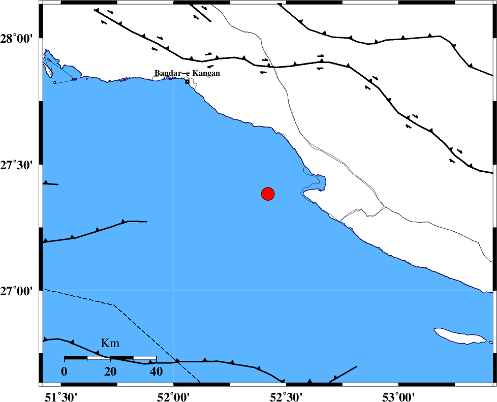
| Location | Lat:27.383 Lon: 52.419 |
| Region | Persian Gulf, 51 km South-East of Jam |
Nearest Cities |
|
| 21 km West of Bandar-e asaluyeh, Bushehr Province | |
| 32 km South of Bandar-e taheri, Bushehr Province | |
| 37 km North West of Chah-e mobarak, Bushehr Province | |
| 39 km South West of Gallehdar, Fars Province | |
| 44 km South West of Ardavan-e olia, Fars Province | |
| Depth | 12 km |
| Agency | |
Faults within 150 km: |
|
| MFF3 (Length: 292 km) , Distance to epicenter: 26 km | |
| BORAZJAN_F (Length: 168 km) , Distance to epicenter: 105 km | |
| MFF5 (Length: 74 km) , Distance to epicenter: 119 km | |
| Number of Phases | 8 |
| RMS | 0.7 |
| Number of Stations | 8 |
| Error in Latitude | >6.3 km |
| Error in Longitude | 6.3 km |
| Error in Depth | 32.1 km |
Download waveform in seisan format
to download seisan software Click here
to access information about IIEES stations Click here
Amplitude | ||||||||
| UID | Agency | Station | Component | Amplitude | Period | Arrival Time | Proccessing Time | Signal Clip |
| 199298 | IIEES SC | NASN | Z | 0.05 | 1 | 2025-09-25 10:38:32 | 2025-09-27 06:12:00 | n |
| 199299 | IIEES SC | IRSR | Z | 0.01 | 1 | 2025-09-25 10:39:00 | 2025-09-27 06:12:00 | n |
Phase | ||||||||||||
| Agency | Station | Component | Phase Type | Phase Quality | First Motion | Observed Arrival Time | Time Residual | Loc. Flag | Input Weight | Distance | Azimuth | |
| IIEES SC | GHIR | Z | EPg | E | 2025-09-25 10:37:29 | 0.8 | y | 0 | 115 | 29 | ||
| IIEES SC | KRBR | Z | EPn | E | 2025-09-25 10:38:18 | -2.7 | n | 4 | 513 | 56 | ||
| IIEES SC | YZKH | Z | EPn | E | 2025-09-25 10:38:10 | -20.4 | n | 4 | 593 | 21 | ||
| IIEES SC | NASN | Z | EPn | E | 2025-09-25 10:38:32 | 0.4 | y | 0 | 602 | 4 | ||
| IIEES SC | RAYN | Z | EPn | E | 2025-09-25 10:38:58 | 0.6 | y | 0 | 816 | 238 | ||
| IIEES SC | ASAO | Z | EPn | E | 2025-09-25 10:38:58 | -1 | y | 0 | 827 | 344 | ||
| IIEES SC | IRSR | Z | EPn | E | 2025-09-25 10:39:00 | -0.6 | y | 0 | 838 | 93 | ||
| IIEES SC | DAMV | Z | EPn | E | 2025-09-25 10:38:56 | -13.8 | n | 4 | 915 | 357 | ||