
Magnitude |
:3 |
| Date & Time (UTC) | 2025-07-29 06:14:51.0 |
| Date & Time (Local) | 1404/5/7 09:44:51.0 |
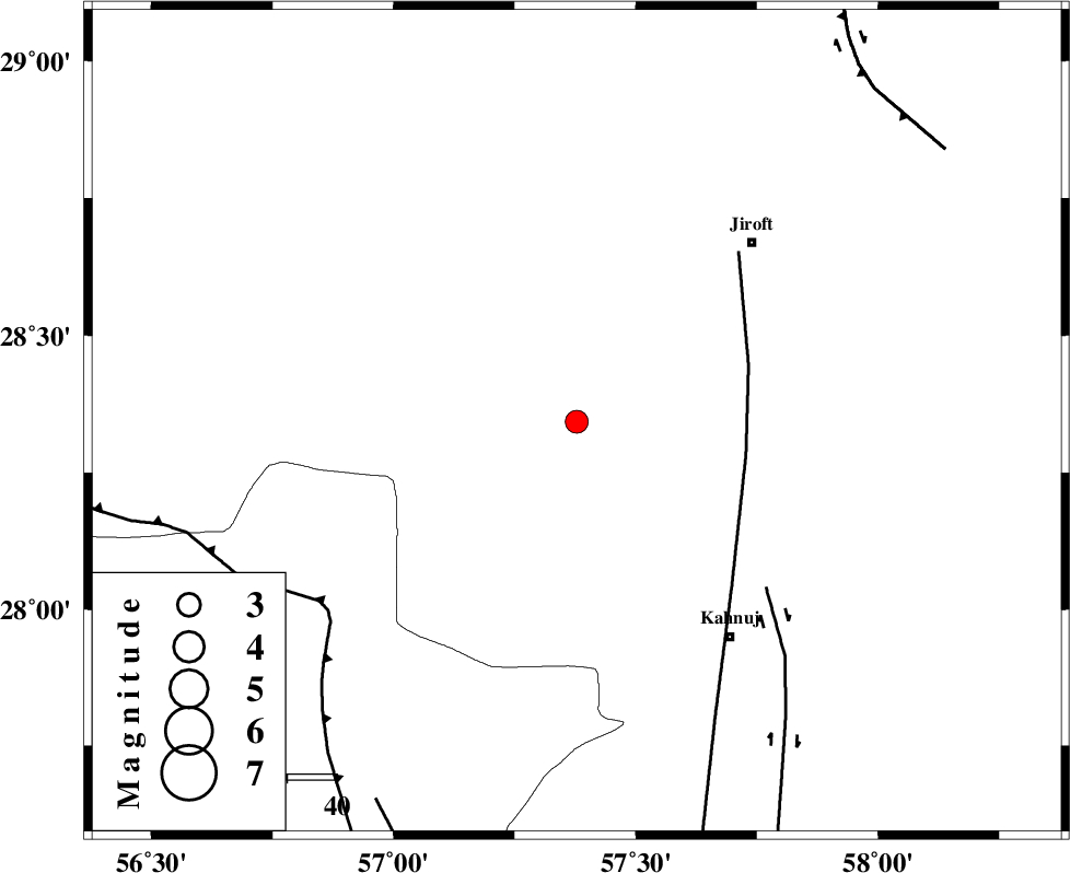
| Location | Lat:28.343 Lon: 57.378 |
| Region | Kerman Province, 51 km South-West of Jiroft |
Nearest Cities |
|
| 18 km North of Hurpasefid, Kerman Province | |
| 22 km North West of Bolock, Kerman Province | |
| 28 km North of Mehrueye-e paeen, Kerman Province | |
| 33 km North East of Faryab, Kerman Province | |
| 41 km South West of Khatunabad-e zangian, Kerman Province | |
| Depth | 12 km |
| Agency | |
Faults within 150 km: |
|
| SABZEVARAN_F (Length: 190 km) , Distance to epicenter: 35 km | |
| JIROFT_F (Length: 144 km) , Distance to epicenter: 51 km | |
| MAIN_ZAGROS_R_F (Length: 1106 km) , Distance to epicenter: 63 km | |
| Number of Phases | 7 |
| RMS | 0.2 |
| Number of Stations | 7 |
| Error in Latitude | >28.3 km |
| Error in Longitude | 57.4 km |
| Error in Depth | 12 km |
Download waveform in seisan format
to download seisan software Click here
to access information about IIEES stations Click here
Amplitude | ||||||||
| UID | Agency | Station | Component | Amplitude | Period | Arrival Time | Proccessing Time | Signal Clip |
| 199225 | IIEES SC | KRBR | Z | 0.8 | 1 | 2025-07-29 06:15:22 | 2025-09-20 10:06:00 | n |
| 199226 | IIEES SC | IRSR | Z | 0.01 | 1 | 2025-07-29 06:15:45 | 2025-09-20 10:06:00 | n |
| 199227 | IIEES SC | SHRT | Z | 0.02 | 1 | 2025-07-29 06:16:20 | 2025-09-20 10:06:00 | n |
Phase | ||||||||||||
| Agency | Station | Component | Phase Type | Phase Quality | First Motion | Observed Arrival Time | Time Residual | Loc. Flag | Input Weight | Distance | Azimuth | |
| IIEES SC | KRBR | Z | EPg | E | 2025-07-29 06:15:22 | -0.2 | y | 0 | 191 | 342 | ||
| IIEES SC | IRSR | Z | EPn | E | 2025-07-29 06:15:45 | -0.1 | y | 0 | 376 | 114 | ||
| IIEES SC | GHIR | Z | EPn | E | 2025-07-29 06:15:52 | 0 | y | 0 | 431 | 269 | ||
| IIEES SC | BSRN | Z | EPn | E | 2025-07-29 06:15:43 | -9.6 | n | 4 | 435 | 23 | ||
| IIEES SC | YZKH | Z | EPn | E | 2025-07-29 06:15:36 | -27.6 | n | 4 | 522 | 329 | ||
| IIEES SC | SHRT | Z | EPn | E | 2025-07-29 06:16:20 | 0.5 | y | 0 | 650 | 25 | ||
| IIEES SC | KAGH | Z | EPn | E | 2025-07-29 06:18:04 | 63.5 | n | 4 | 983 | 14 | ||