
Magnitude |
:3.7 |
| Date & Time (UTC) | 2025-07-29 06:39:17.4 |
| Date & Time (Local) | 1404/5/7 10:09:17.4 |
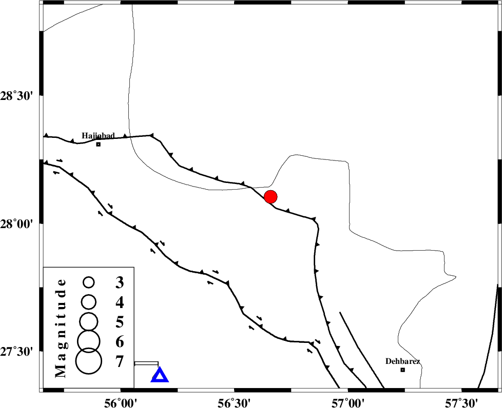
| Location | Lat:28.104 Lon: 56.659 |
| Region | Hormozgan Province, 78 km South-East of Hajiabad |
Nearest Cities |
|
| 34 km South West of Sarkhan, Kerman Province | |
| 43 km North East of Fareqan, Hormozgan Province | |
| 47 km South East of Arzuieeh, Kerman Province | |
| 48 km South East of Shahmaran, Kerman Province | |
| 60 km North West of Faryab, Kerman Province | |
| Depth | 12 km |
| Agency | |
Faults within 150 km: |
|
| MAIN_ZAGROS_R_F (Length: 1106 km) , Distance to epicenter: 3 km | |
| HZF2 (Length: 437 km) , Distance to epicenter: 42 km | |
| ZENDAN_MINAB_F_Z1 (Length: 183 km) , Distance to epicenter: 58 km | |
| Number of Phases | 10 |
| RMS | 0.5 |
| Number of Stations | 10 |
| Error in Latitude | >2.8 km |
| Error in Longitude | 2.8 km |
| Error in Depth | 19.3 km |
Download waveform in seisan format
to download seisan software Click here
to access information about IIEES stations Click here
Amplitude | ||||||||
| UID | Agency | Station | Component | Amplitude | Period | Arrival Time | Proccessing Time | Signal Clip |
| 199221 | IIEES SC | KRBR | Z | 2 | 1 | 2025-07-29 06:39:50 | 2025-09-20 09:53:00 | n |
| 199222 | IIEES SC | UOSS | Z | 0.2 | 1 | 2025-07-29 06:40:08 | 2025-09-20 09:53:00 | n |
| 199223 | IIEES SC | IRSR | Z | 0.04 | 1 | 2025-07-29 06:40:19 | 2025-09-20 09:53:00 | n |
| 199224 | IIEES SC | SHRT | Z | 0.04 | 1 | 2025-07-29 06:40:53 | 2025-09-20 09:53:00 | n |
Phase | ||||||||||||
| Agency | Station | Component | Phase Type | Phase Quality | First Motion | Observed Arrival Time | Time Residual | Loc. Flag | Input Weight | Distance | Azimuth | |
| IIEES SC | KRBR | Z | EPn | E | 2025-07-29 06:39:50 | -0.5 | y | 0 | 208 | 3 | ||
| IIEES SC | UOSS | Z | EPn | E | 2025-07-29 06:40:08 | -0.6 | y | 0 | 353 | 187 | ||
| IIEES SC | GHIR | Z | EPn | E | 2025-07-29 06:40:10 | 0.3 | y | 0 | 361 | 273 | ||
| IIEES SC | IRSR | Z | EPn | E | 2025-07-29 06:40:19 | 0.4 | y | 0 | 434 | 107 | ||
| IIEES SC | BSRN | Z | EPn | E | 2025-07-29 06:40:18 | -7.4 | n | 4 | 490 | 29 | ||
| IIEES SC | YZKH | Z | EPn | E | 2025-07-29 06:40:08 | -20.8 | n | 4 | 515 | 337 | ||
| IIEES SC | TABS | Z | EPn | E | 2025-07-29 06:40:45 | 3.3 | n | 4 | 616 | 4 | ||
| IIEES SC | SHRT | Z | EPn | E | 2025-07-29 06:40:53 | 0.4 | y | 0 | 706 | 29 | ||
| IIEES SC | RAYN | Z | EPn | E | 2025-07-29 06:41:52 | -5.8 | n | 4 | 1228 | 246 | ||
| IIEES SC | SRSL | Z | EPn | E | 2025-07-29 06:41:52 | -25.3 | n | 4 | 1389 | 310 | ||