
Magnitude |
:3.5 |
| Date & Time (UTC) | 2025-09-12 04:18:45.2 |
| Date & Time (Local) | 1404/6/21 07:48:45.2 |
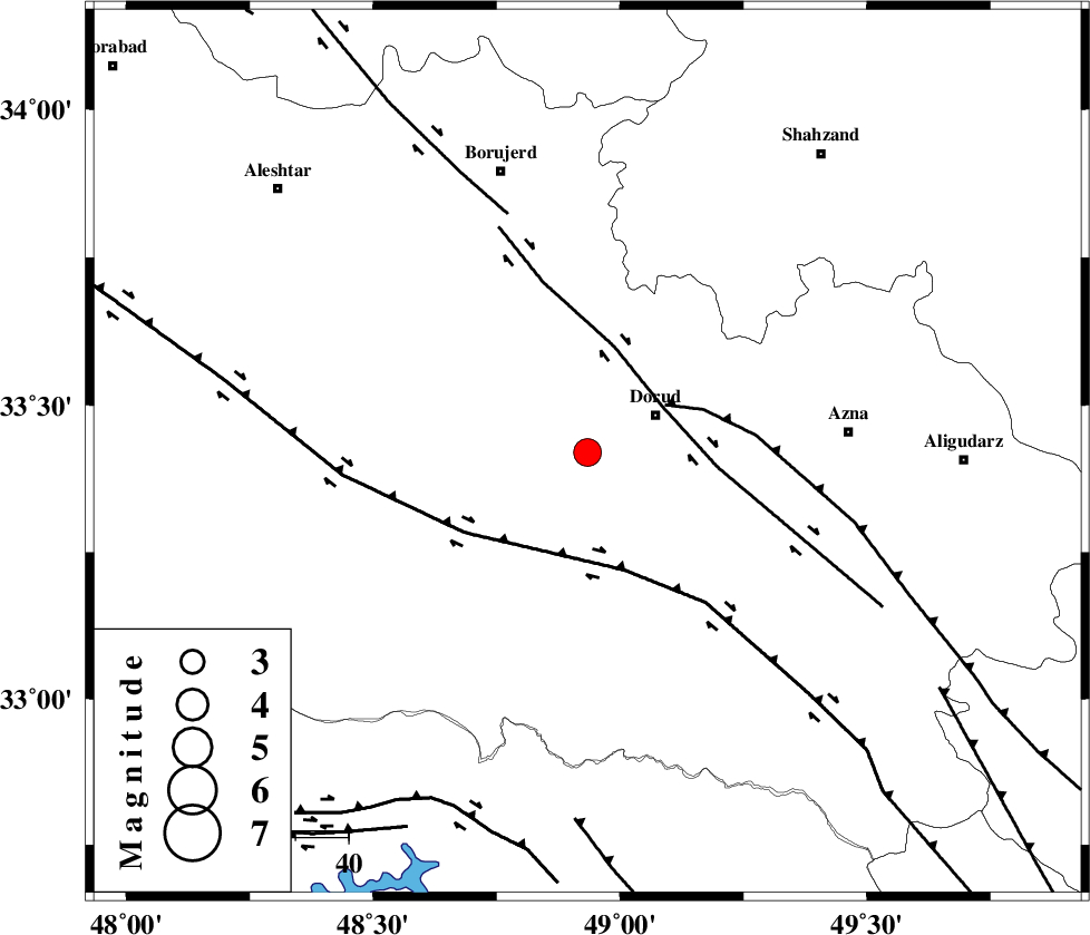
| Location | Lat:33.419 Lon: 48.934 |
| Region | Lorestan Province, 15 km -West of Dorud |
Nearest Cities |
|
| 13 km South of Void, Lorestan Province | |
| 15 km West of Dorud, Lorestan Province | |
| 17 km North of Sartang barzeh, Lorestan Province | |
| 17 km South of Razan, Lorestan Province | |
| 21 km South of Kagheh, Lorestan Province | |
| Depth | 12 km |
| Agency | |
Faults within 150 km: |
|
| DORUD (Length: 100 km) , Distance to epicenter: 17 km | |
| MAIN_ZAGROS_R_F (Length: 1106 km) , Distance to epicenter: 17 km | |
| HZF4 (Length: 492 km) , Distance to epicenter: 23 km | |
| Number of Phases | 7 |
| RMS | 0.2 |
| Number of Stations | 7 |
| Error in Latitude | >33.4 km |
| Error in Longitude | 48.9 km |
| Error in Depth | 12 km |
Download waveform in seisan format
to download seisan software Click here
to access information about IIEES stations Click here
Amplitude | ||||||||
| UID | Agency | Station | Component | Amplitude | Period | Arrival Time | Proccessing Time | Signal Clip |
| 199083 | IIEES SC | NASN | Z | 0.1 | 1 | 2025-09-12 04:19:39 | 2025-09-14 07:09:00 | n |
| 199084 | IIEES SC | SRSL | Z | 0.09 | 1 | 2025-09-12 04:19:48 | 2025-09-14 07:09:00 | n |
| 199085 | IIEES SC | TABS | Z | 0.01 | 1 | 2025-09-12 04:20:27 | 2025-09-14 07:09:00 | n |
Phase | ||||||||||||
| Agency | Station | Component | Phase Type | Phase Quality | First Motion | Observed Arrival Time | Time Residual | Loc. Flag | Input Weight | Distance | Azimuth | |
| IIEES SC | ASAO | Z | EPg | E | 2025-09-12 04:19:09 | -2.8 | n | 4 | 161 | 39 | ||
| IIEES SC | NASN | Z | EPn | E | 2025-09-12 04:19:39 | 0.5 | y | 0 | 368 | 101 | ||
| IIEES SC | DAMV | Z | EPn | E | 2025-09-12 04:19:33 | -6.2 | n | 4 | 372 | 49 | ||
| IIEES SC | SRSL | Z | EPn | E | 2025-09-12 04:19:48 | 0 | y | 0 | 446 | 314 | ||
| IIEES SC | GHIR | Z | EPn | E | 2025-09-12 04:20:18 | -0.2 | y | 0 | 689 | 146 | ||
| IIEES SC | SHRO | Z | EPn | E | 2025-09-12 04:20:11 | -9.8 | n | 4 | 709 | 66 | ||
| IIEES SC | TABS | Z | EPn | E | 2025-09-12 04:20:27 | -0.1 | y | 0 | 761 | 88 | ||