
Magnitude |
:3.3 |
| Date & Time (UTC) | 2025-09-06 06:14:43.3 |
| Date & Time (Local) | 1404/6/15 09:44:43.3 |
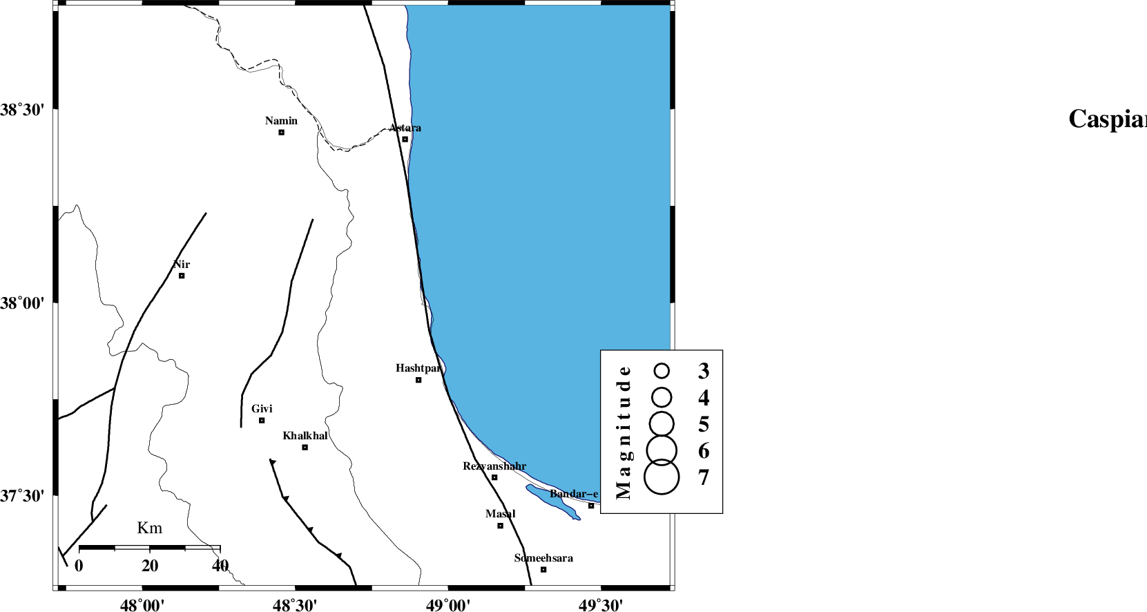
| Location | Lat:38.015 Lon: 48.724 |
| Region | Gilan Province, 29 km North-West of Hashtpar |
Nearest Cities |
|
| 18 km North West of Lisar, Gilan Province | |
| 22 km South East of Hir, Ardebil Province | |
| 22 km South West of Hariq, Gilan Province | |
| 22 km North of Kish dini, Gilan Province | |
| 24 km North West of Chelonasr, Gilan Province | |
| Depth | 12 km |
| Agency | |
Faults within 150 km: |
|
| TALESH_F (Length: 258 km) , Distance to epicenter: 21 km | |
| SANGAVAR_F (Length: 61 km) , Distance to epicenter: 21 km | |
| BOZQUSH (Length: 70 km) , Distance to epicenter: 51 km | |
| Number of Phases | 8 |
| RMS | 0.6 |
| Number of Stations | 8 |
| Error in Latitude | >8.3 km |
| Error in Longitude | 8.3 km |
| Error in Depth | 999 km |
Download waveform in seisan format
to download seisan software Click here
to access information about IIEES stations Click here
Amplitude | ||||||||
| UID | Agency | Station | Component | Amplitude | Period | Arrival Time | Proccessing Time | Signal Clip |
| 199041 | IIEES SC | SRSL | Z | 0.09 | 1 | 2025-09-06 06:15:35 | 2025-09-07 08:31:00 | n |
| 199042 | IIEES SC | ABGH | Z | 0.02 | 1 | 2025-09-06 06:15:59 | 2025-09-07 08:31:00 | n |
| 199043 | IIEES SC | BJRD | Z | 0.01 | 1 | 2025-09-06 06:16:25 | 2025-09-07 08:31:00 | n |
Phase | ||||||||||||
| Agency | Station | Component | Phase Type | Phase Quality | First Motion | Observed Arrival Time | Time Residual | Loc. Flag | Input Weight | Distance | Azimuth | |
| IIEES SC | GRMI | Z | EPg | E | 2025-09-06 06:14:36 | -26.5 | n | 4 | 114 | 320 | ||
| IIEES SC | GRMI | Z | ESg | E | 2025-09-06 06:14:46 | -29.9 | n | 4 | 114 | 320 | ||
| IIEES SC | CHTH | Z | EPn | E | 2025-09-06 06:15:31 | 0.7 | y | 0 | 317 | 138 | ||
| IIEES SC | SRSL | Z | EPn | E | 2025-09-06 06:15:35 | -0.3 | y | 0 | 354 | 236 | ||
| IIEES SC | GNI | Z | EPn | E | 2025-09-06 06:15:43 | 0.3 | y | 0 | 418 | 304 | ||
| IIEES SC | ABGH | Z | EPn | E | 2025-09-06 06:15:59 | -1 | y | 0 | 556 | 105 | ||
| IIEES SC | SHRO | Z | EPn | E | 2025-09-06 06:16:11 | -5.5 | n | 4 | 686 | 109 | ||
| IIEES SC | BJRD | Z | EPn | E | 2025-09-06 06:16:25 | -0.9 | y | 0 | 765 | 93 | ||