
Magnitude |
:3.9 |
| Date & Time (UTC) | 2025-08-28 10:29:27.7 |
| Date & Time (Local) | 1404/6/6 13:59:27.7 |
| Location | Lat:34.333 Lon: 45.748 |
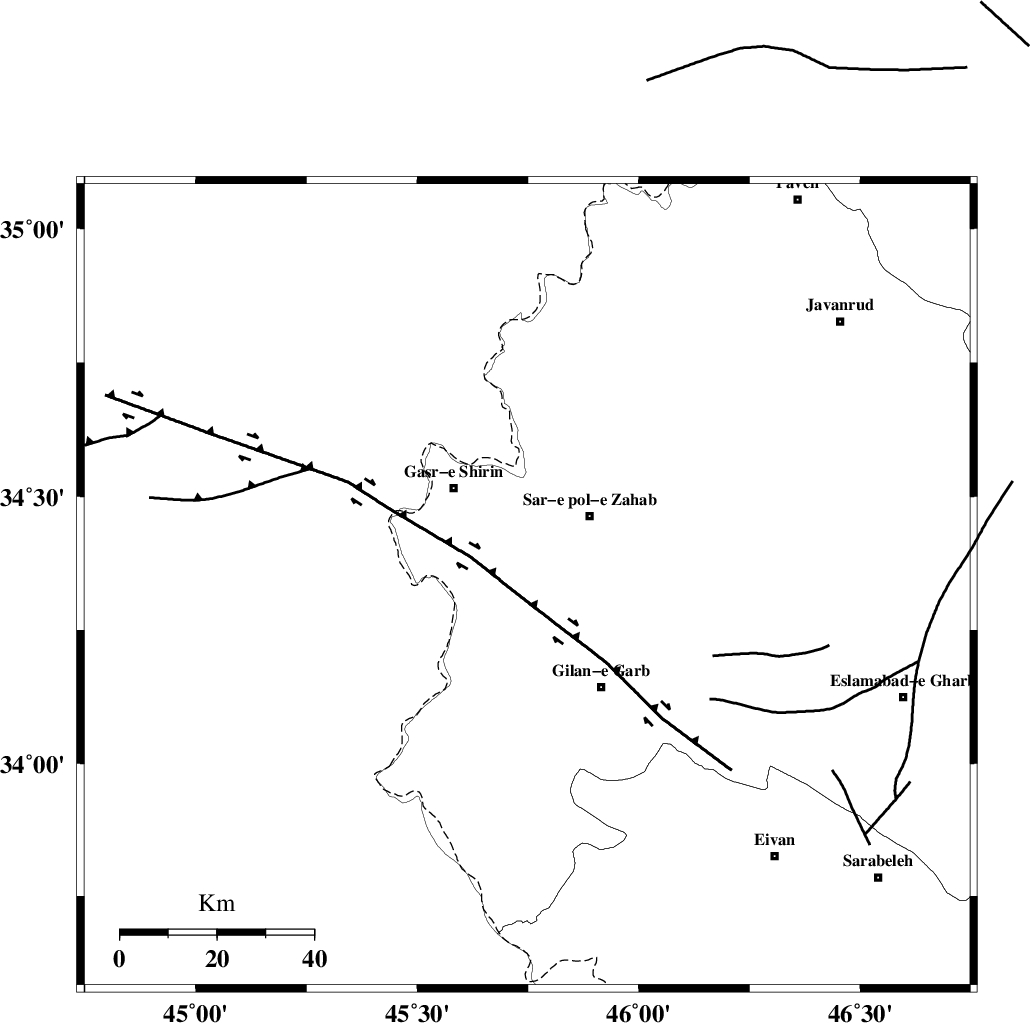
| Region | Kermanshah Province, 19 km South-West of Sar-e pol-e zahab |
Nearest Cities |
|
| 10 km North West of Chub baghan, Kermanshah Province | |
| 17 km South of Qareh belagh, Kermanshah Province | |
| 18 km West of Tarkveys, Kermanshah Province | |
| 19 km South East of Seyyed sohrab, Kermanshah Province | |
| 19 km South West of Sar-e pol-e zahab, Kermanshah Province | |
| Depth | 12 km |
| Agency | |
Faults within 150 km: |
|
| MFF8 (Length: 48 km) , Distance to epicenter: 21 km | |
| ZFF4 (Length: 128 km) , Distance to epicenter: 51 km | |
| MFF7 (Length: 99 km) , Distance to epicenter: 51 km | |
| Number of Phases | 5 |
| RMS | 0.6 |
| Number of Stations | 5 |
| Error in Latitude | >16.6 km |
| Error in Longitude | 16.6 km |
| Error in Depth | 25.6 km |
Download waveform in seisan format
to download seisan software Click here
to access information about IIEES stations Click here
Amplitude | ||||||||
| UID | Agency | Station | Component | Amplitude | Period | Arrival Time | Proccessing Time | Signal Clip |
| 198941 | IIEES SC | SRSL | Z | 3 | 1 | 2025-08-28 10:30:02 | 2025-08-30 06:53:00 | n |
| 198942 | IIEES SC | SRSL | Z | 3 | 1 | 2025-08-28 10:30:26 | 2025-08-30 06:53:00 | n |
| 198943 | IIEES SC | GHVR | Z | 0.2 | 1 | 2025-08-28 10:30:39 | 2025-08-30 06:53:00 | n |
| 198944 | IIEES SC | NASN | Z | 0.02 | 1 | 2025-08-28 10:30:59 | 2025-08-30 06:53:00 | n |
Phase | ||||||||||||
| Agency | Station | Component | Phase Type | Phase Quality | First Motion | Observed Arrival Time | Time Residual | Loc. Flag | Input Weight | Distance | Azimuth | |
| IIEES SC | SRSL | Z | EPn | E | 2025-08-28 10:30:02 | 0.2 | y | 0 | 210 | 352 | ||
| IIEES SC | SRSL | Z | ES | E | 2025-08-28 10:30:26 | 0 | y | 0 | 210 | 352 | ||
| IIEES SC | GHVR | Z | EPn | E | 2025-08-28 10:30:39 | 1 | y | 0 | 506 | 88 | ||
| IIEES SC | NASN | Z | EPn | E | 2025-08-28 10:30:59 | -0.9 | y | 0 | 677 | 105 | ||
| IIEES SC | GHIR | Z | EPn | E | 2025-08-28 10:31:34 | -0.9 | y | 0 | 962 | 134 | ||