
Magnitude |
:3.1 |
| Date & Time (UTC) | 2025-08-24 02:52:25.8 |
| Date & Time (Local) | 1404/6/2 06:22:25.8 |
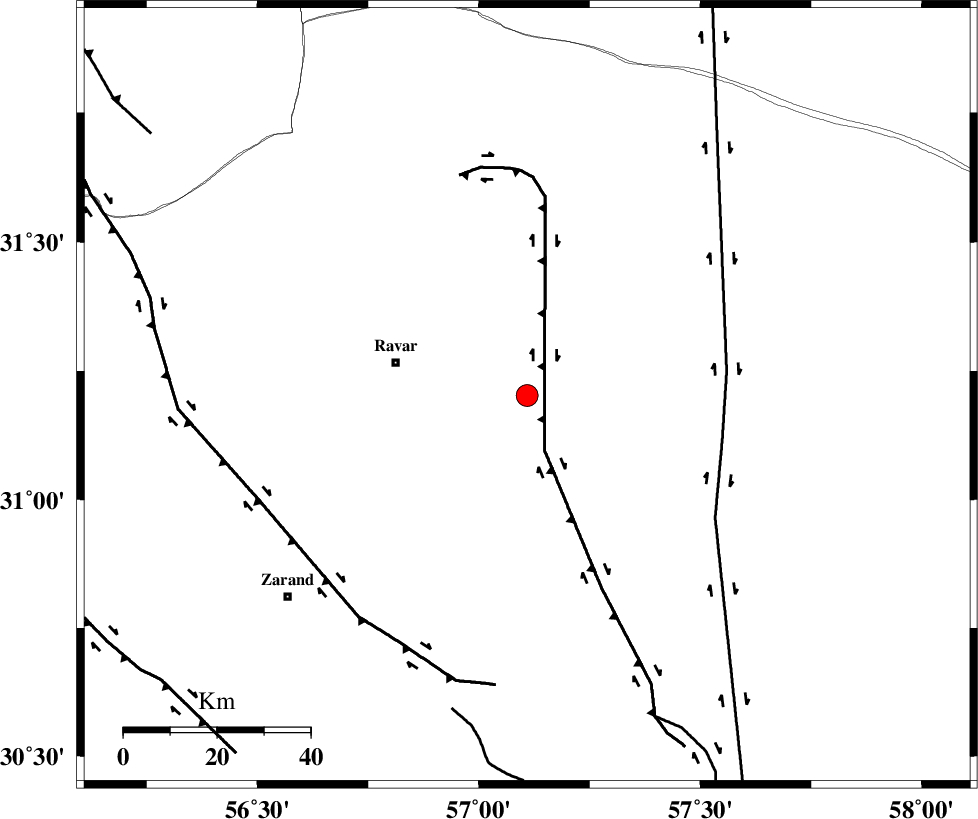
| Location | Lat:31.202 Lon: 57.109 |
| Region | Kerman Province, 29 km -East of Ravar |
Nearest Cities |
|
| 29 km East of Ravar, Kerman Province | |
| 33 km South East of Dehali, Kerman Province | |
| 50 km North East of Hatkan, Kerman Province | |
| 50 km North East of Ahmadi, Kerman Province | |
| 51 km North East of Hejdak, Kerman Province | |
| Depth | 12 km |
| Agency | |
Faults within 150 km: |
|
| LAKARKUH_F (Length: 138 km) , Distance to epicenter: 12 km | |
| NAYBAND_F (Length: 258 km) , Distance to epicenter: 43 km | |
| KUHBANAN_F (Length: 189 km) , Distance to epicenter: 60 km | |
| Number of Phases | 7 |
| RMS | 0.9 |
| Number of Stations | 7 |
| Error in Latitude | >1.2 km |
| Error in Longitude | 1.2 km |
| Error in Depth | 7.2 km |
Download waveform in seisan format
to download seisan software Click here
to access information about IIEES stations Click here
Amplitude | ||||||||
| UID | Agency | Station | Component | Amplitude | Period | Arrival Time | Proccessing Time | Signal Clip |
| 198902 | IIEES SC | KRBR | Z | 1 | 1 | 2025-08-24 02:52:48 | 2025-08-25 08:41:00 | n |
| 198903 | IIEES SC | TABS | Z | 0.2 | 1 | 2025-08-24 02:53:06 | 2025-08-25 08:41:00 | n |
| 198904 | IIEES SC | SHRT | Z | 0.03 | 1 | 2025-08-24 02:53:22 | 2025-08-25 08:41:00 | n |
| 198905 | IIEES SC | NASN | Z | 0.02 | 1 | 2025-08-24 02:53:30 | 2025-08-25 08:41:00 | n |
Phase | ||||||||||||
| Agency | Station | Component | Phase Type | Phase Quality | First Motion | Observed Arrival Time | Time Residual | Loc. Flag | Input Weight | Distance | Azimuth | |
| IIEES SC | KRBR | Z | EPg | E | 2025-08-24 02:52:48 | -0.9 | y | 0 | 139 | 194 | ||
| IIEES SC | BSRN | Z | EPn | E | 2025-08-24 02:52:45 | -14.1 | n | 4 | 209 | 66 | ||
| IIEES SC | TABS | Z | EPn | E | 2025-08-24 02:53:06 | -0.7 | y | 0 | 271 | 0 | ||
| IIEES SC | YZKH | Z | EPn | E | 2025-08-24 02:52:40 | -27.3 | n | 4 | 272 | 299 | ||
| IIEES SC | ZHSF | Z | EPn | E | 2025-08-24 02:53:23 | 1 | y | 0 | 393 | 117 | ||
| IIEES SC | SHRT | Z | EPn | E | 2025-08-24 02:53:22 | -1 | y | 0 | 404 | 48 | ||
| IIEES SC | NASN | Z | EPn | E | 2025-08-24 02:53:30 | 1 | y | 0 | 443 | 294 | ||