
Magnitude |
:3.1 |
| Date & Time (UTC) | 2025-05-04 01:38:58.0 |
| Date & Time (Local) | 1404/2/14 05:08:58.0 |
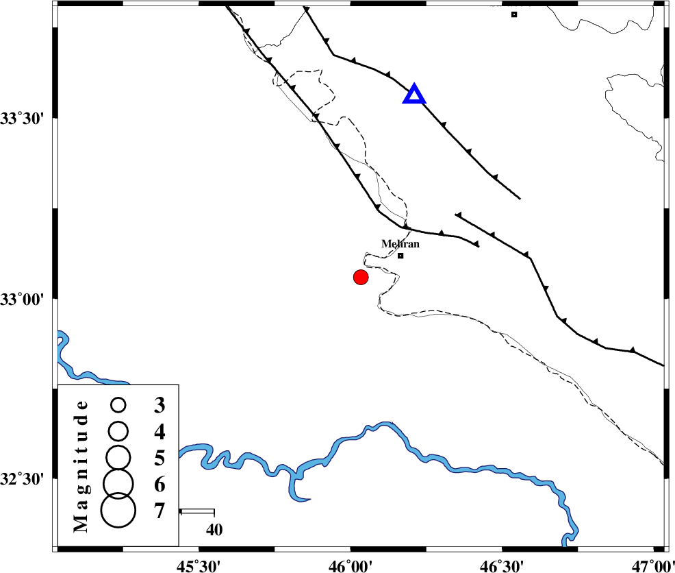
| Location | Lat:33.059 Lon: 46.034 |
| Region | Iraq, 14 km -West of Mehran |
Nearest Cities |
|
| 14 km West of Mehran, Ilam Province | |
| 48 km South West of Salehabad, Ilam Province | |
| 48 km South West of Galeh-yedarre-hemalakshahi, Ilam Province | |
| 53 km South West of Gonbad-e pirmohammad, Ilam Province | |
| 59 km South West of Mehr, Ilam Province | |
| Depth | 12 km |
| Agency | |
Faults within 150 km: |
|
| ZFF4 (Length: 128 km) , Distance to epicenter: 20 km | |
| MFF6 (Length: 144 km) , Distance to epicenter: 35 km | |
| MFF7 (Length: 99 km) , Distance to epicenter: 51 km | |
| Number of Phases | 5 |
| RMS | 0.2 |
| Number of Stations | 5 |
| Error in Latitude | >5.7 km |
| Error in Longitude | 5.7 km |
| Error in Depth | 451.5 km |
Download waveform in seisan format
to download seisan software Click here
to access information about IIEES stations Click here
Amplitude | ||||||||
| UID | Agency | Station | Component | Amplitude | Period | Arrival Time | Proccessing Time | Signal Clip |
| 198079 | IIEES SC | ASAO | Z | 0.09 | 1 | 2025-05-04 01:39:56 | 2025-05-04 04:46:00 | n |
| 198080 | IIEES SC | NASN | Z | 0.01 | 1 | 2025-05-04 01:40:24 | 2025-05-04 04:46:00 | n |
| 198081 | IIEES SC | GHIR | Z | 0.001 | 1 | 2025-05-04 01:40:51 | 2025-05-04 04:46:00 | n |
Phase | ||||||||||||
| Agency | Station | Component | Phase Type | Phase Quality | First Motion | Observed Arrival Time | Time Residual | Loc. Flag | Input Weight | Distance | Azimuth | |
| IIEES SC | SRSL | Z | EPn | E | 2025-05-04 01:39:50 | 0 | y | 0 | 354 | 351 | ||
| IIEES SC | ASAO | Z | EPn | E | 2025-05-04 01:39:56 | -0.1 | y | 0 | 405 | 66 | ||
| IIEES SC | GHVR | Z | EPn | E | 2025-05-04 01:40:09 | 0.4 | y | 0 | 508 | 72 | ||
| IIEES SC | NASN | Z | EPn | E | 2025-05-04 01:40:24 | -0.5 | y | 0 | 634 | 93 | ||
| IIEES SC | GHIR | Z | EPn | E | 2025-05-04 01:40:51 | 0.2 | y | 0 | 851 | 128 | ||