
Magnitude |
:3.2 |
| Date & Time (UTC) | 2025-04-03 04:11:34.2 |
| Date & Time (Local) | 1404/1/14 07:41:34.2 |
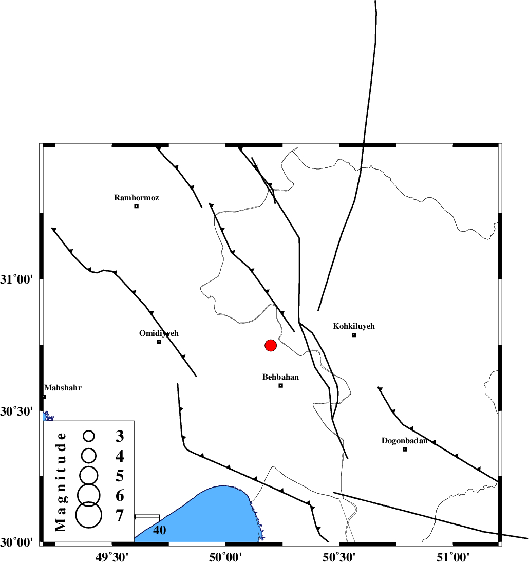
| Location | Lat:30.748 Lon: 50.198 |
| Region | Khoozestan Province, 17 km North of Behbahan |
Nearest Cities |
|
| 4 km North of Dodange-ye bozorg, Khoozestan Province | |
| 16 km North West of Mansuriyeh, Khoozestan Province | |
| 17 km North of Behbahan, Khoozestan Province | |
| 29 km East of Jolaki, Khoozestan Province | |
| 34 km South West of Lendeh, Kohkiluieh va boyerahmad Province | |
| Depth | 12 km |
| Agency | |
Faults within 150 km: |
|
| MFF4 (Length: 62 km) , Distance to epicenter: 12 km | |
| AGHAJARI_F (Length: 88 km) , Distance to epicenter: 34 km | |
| RAG_E_SEFID_F (Length: 84 km) , Distance to epicenter: 42 km | |
| Number of Phases | 8 |
| RMS | 0.3 |
| Number of Stations | 8 |
| Error in Latitude | >1.7 km |
| Error in Longitude | 1.7 km |
| Error in Depth | 387.5 km |
Download waveform in seisan format
to download seisan software Click here
to access information about IIEES stations Click here
Amplitude | ||||||||
| UID | Agency | Station | Component | Amplitude | Period | Arrival Time | Proccessing Time | Signal Clip |
| 197772 | IIEES SC | ASAO | Z | 0.05 | 1 | 2025-04-03 04:12:35 | 2025-04-08 11:41:00 | n |
| 197773 | IIEES SC | GHVR | Z | 0.07 | 1 | 2025-04-03 04:12:34 | 2025-04-08 11:41:00 | n |
| 197774 | IIEES SC | TABS | Z | 0.007 | 1 | 2025-04-03 04:13:12 | 2025-04-08 11:41:00 | n |
Phase | ||||||||||||
| Agency | Station | Component | Phase Type | Phase Quality | First Motion | Observed Arrival Time | Time Residual | Loc. Flag | Input Weight | Distance | Azimuth | |
| IIEES SC | GHIR | Z | EPn | E | 2025-04-03 04:12:29 | -0.1 | y | 0 | 384 | 135 | ||
| IIEES SC | ASAO | Z | EPn | E | 2025-04-03 04:12:35 | 0.5 | y | 0 | 422 | 358 | ||
| IIEES SC | GHVR | Z | EPn | E | 2025-04-03 04:12:34 | -0.1 | y | 0 | 425 | 13 | ||
| IIEES SC | YZKH | Z | EPn | E | 2025-04-03 04:12:39 | 0.7 | y | 0 | 455 | 66 | ||
| IIEES SC | CHTH | Z | EPn | E | 2025-04-03 04:12:53 | -0.7 | y | 0 | 579 | 9 | ||
| IIEES SC | TABS | Z | EPn | E | 2025-04-03 04:13:12 | 0.4 | y | 0 | 728 | 64 | ||
| IIEES SC | SRSL | Z | EPn | E | 2025-04-03 04:13:15 | -0.1 | y | 0 | 751 | 324 | ||
| IIEES SC | RAYN | Z | EPn | E | 2025-04-03 04:13:37 | 0.2 | y | 0 | 926 | 210 | ||