
Magnitude |
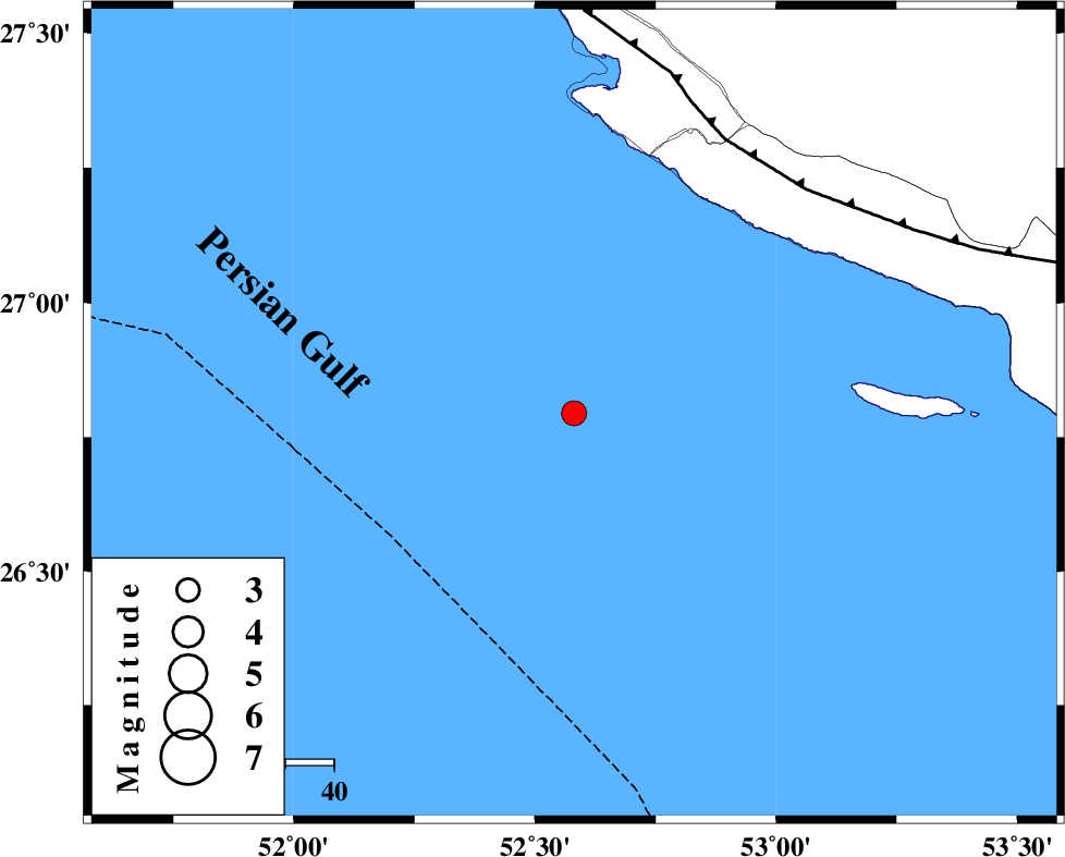
:3.3 |
| Date & Time (UTC) | 2025-03-20 23:20:42.7 |
| Date & Time (Local) | 1404/1/1 02:50:42.7 |
| Location | Lat:26.794 Lon: 52.581 |
| Region | Persian Gulf, 89 km South-West of Mehr |
Nearest Cities |
|
| 66 km South West of Chah-e mobarak, Bushehr Province | |
| 75 km South of Bandar-e asaluyeh, Bushehr Province | |
| 82 km South West of Khoozi, Fars Province | |
| 83 km South West of Lamerd, Fars Province | |
| 89 km South West of Mehr, Fars Province | |
| Depth | 12 km |
| Agency | |
Faults within 150 km: |
|
| MFF3 (Length: 292 km) , Distance to epicenter: 65 km | |
| ZFF1 (Length: 165 km) , Distance to epicenter: 116 km | |
| MFF1 (Length: 180 km) , Distance to epicenter: 149 km | |
| Number of Phases | 6 |
| RMS | 0.1 |
| Number of Stations | 6 |
| Error in Latitude | >1.2 km |
| Error in Longitude | 1.2 km |
| Error in Depth | 8.1 km |
Download waveform in seisan format
to download seisan software Click here
to access information about IIEES stations Click here
Amplitude | ||||||||
| UID | Agency | Station | Component | Amplitude | Period | Arrival Time | Proccessing Time | Signal Clip |
| 197743 | IIEES SC | UOSS | Z | 0.03 | 1 | 2025-03-20 23:21:42 | 2025-04-08 11:05:00 | n |
| 197744 | IIEES SC | KRBR | Z | 0.03 | 1 | 2025-03-20 23:21:58 | 2025-04-08 11:05:00 | n |
| 197745 | IIEES SC | NASN | Z | 0.01 | 1 | 2025-03-20 23:22:13 | 2025-04-08 11:05:00 | n |
| 197746 | IIEES SC | RAYN | Z | 0.02 | 1 | 2025-03-20 23:22:30 | 2025-04-08 11:05:00 | n |
Phase | ||||||||||||
| Agency | Station | Component | Phase Type | Phase Quality | First Motion | Observed Arrival Time | Time Residual | Loc. Flag | Input Weight | Distance | Azimuth | |
| IIEES SC | GHIR | Z | EPg | E | 2025-03-20 23:21:10 | -0.1 | y | 0 | 170 | 14 | ||
| IIEES SC | UOSS | Z | EPn | E | 2025-03-20 23:21:42 | 0 | y | 0 | 417 | 119 | ||
| IIEES SC | KRBR | Z | EPn | E | 2025-03-20 23:21:58 | 0.3 | y | 0 | 541 | 49 | ||
| IIEES SC | YZKH | Z | EPn | E | 2025-03-20 23:22:10 | -1.1 | y | 0 | 650 | 17 | ||
| IIEES SC | NASN | Z | EPn | E | 2025-03-20 23:22:13 | 0.1 | y | 0 | 666 | 2 | ||
| IIEES SC | RAYN | Z | EPn | E | 2025-03-20 23:22:30 | 0 | y | 0 | 800 | 243 | ||