
Magnitude |
:3 |
| Date & Time (UTC) | 2025-03-04 07:33:13.0 |
| Date & Time (Local) | 1403/12/14 11:03:13.0 |
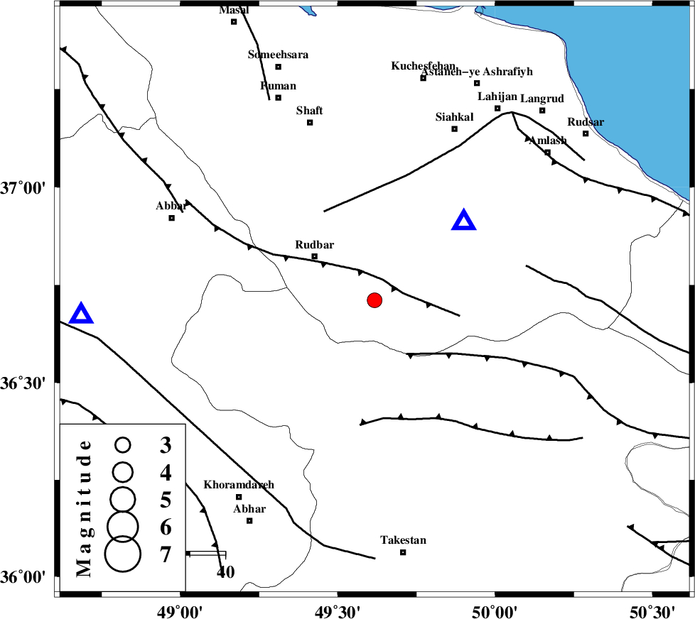
| Location | Lat:36.711 Lon: 49.617 |
| Region | Gilan Province, 21 km South-East of Rudbar |
Nearest Cities |
|
| 14 km North East of Loshan, Gilan Province | |
| 15 km North West of Jirhandeh, Gilan Province | |
| 17 km North of Kuhgir-e sofla, Ghazvin Province | |
| 17 km South of Dashtvil, Gilan Province | |
| 20 km East of Manjil, Gilan Province | |
| Depth | 12 km |
| Agency | |
Faults within 150 km: |
|
| RUDBAR_F (Length: 93 km) , Distance to epicenter: 6 km | |
| ALAMUTRUD_F (Length: 140 km) , Distance to epicenter: 18 km | |
| LAHIJAN_F (Length: 92 km) , Distance to epicenter: 29 km | |
| Number of Phases | 8 |
| RMS | 0.4 |
| Number of Stations | 8 |
| Error in Latitude | >6.2 km |
| Error in Longitude | 6.2 km |
| Error in Depth | 10.7 km |
Download waveform in seisan format
to download seisan software Click here
to access information about IIEES stations Click here
Amplitude | ||||||||
| UID | Agency | Station | Component | Amplitude | Period | Arrival Time | Proccessing Time | Signal Clip |
| 197327 | IIEES SC | SRSL | Z | 0.04 | 1 | 2025-03-04 07:34:08 | 2025-03-05 06:52:00 | n |
| 197328 | IIEES SC | ABGH | Z | 0.03 | 1 | 2025-03-04 07:34:18 | 2025-03-05 06:52:00 | n |
Phase | ||||||||||||
| Agency | Station | Component | Phase Type | Phase Quality | First Motion | Observed Arrival Time | Time Residual | Loc. Flag | Input Weight | Distance | Azimuth | |
| IIEES SC | GIDE | Z | EPg | E | 2025-03-04 07:33:18 | -0.5 | y | 0 | 30 | 38 | ||
| IIEES SC | GIDE | Z | ESg | E | 2025-03-04 07:33:23 | 0.4 | y | 0 | 30 | 38 | ||
| IIEES SC | ZNJK | Z | EPg | E | 2025-03-04 07:33:36 | 9.4 | n | 4 | 83 | 267 | ||
| IIEES SC | GRMI | Z | EPn | E | 2025-03-04 07:33:48 | -6.5 | n | 4 | 278 | 327 | ||
| IIEES SC | GHVR | Z | EPn | E | 2025-03-04 07:33:56 | -0.2 | y | 0 | 288 | 149 | ||
| IIEES SC | GHVR | Z | ES | E | 2025-03-04 07:34:29 | 0.9 | y | 0 | 288 | 149 | ||
| IIEES SC | SRSL | Z | EPn | E | 2025-03-04 07:34:08 | -0.1 | y | 0 | 379 | 262 | ||
| IIEES SC | ABGH | Z | EPn | E | 2025-03-04 07:34:18 | -0.3 | y | 0 | 463 | 90 | ||