
Magnitude |
:2.7 |
| Date & Time (UTC) | 2025-02-19 18:03:16.8 |
| Date & Time (Local) | 1403/12/1 21:33:16.8 |
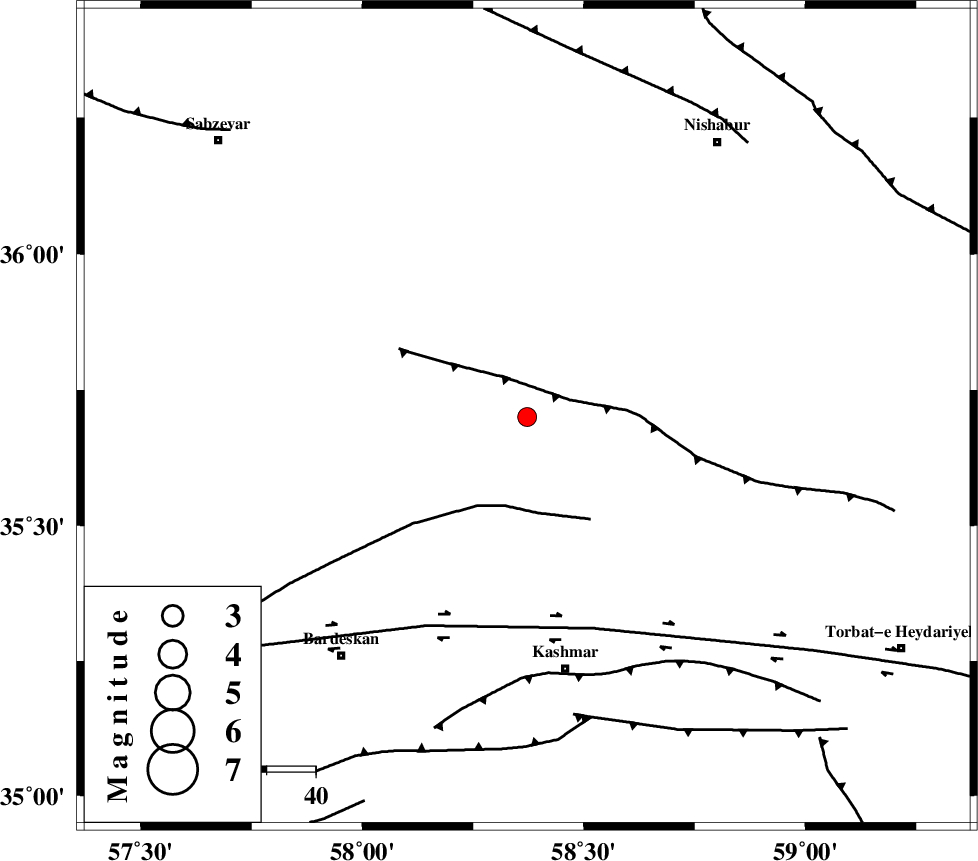
| Location | Lat:35.7 Lon: 58.372 |
| Region | Khorasan(center) Province, 52 km North of Kashmar |
Nearest Cities |
|
| 11 km North of Ondar, Khorasan(center) Province | |
| 22 km North East of Ghaleh meidan, Khorasan(center) Province | |
| 25 km North of Toroq, Khorasan(center) Province | |
| 27 km North of Rivash, Khorasan(center) Province | |
| 37 km South of Fadisheh, Khorasan(center) Province | |
| Depth | 12 km |
| Agency | |
Faults within 150 km: |
|
| BALHAR_F (Length: 117 km) , Distance to epicenter: 9 km | |
| BIJVARD_F (Length: 83 km) , Distance to epicenter: 19 km | |
| DORUNEH_F (Length: 713 km) , Distance to epicenter: 45 km | |
| Number of Phases | 8 |
| RMS | 0.1 |
| Number of Stations | 8 |
| Error in Latitude | >1.4 km |
| Error in Longitude | 1.4 km |
| Error in Depth | 9.4 km |
Download waveform in seisan format
to download seisan software Click here
to access information about IIEES stations Click here
Amplitude | ||||||||
| UID | Agency | Station | Component | Amplitude | Period | Arrival Time | Proccessing Time | Signal Clip |
| 197257 | IIEES SC | SHRO | Z | 0.08 | 1 | 2025-02-19 18:03:51 | 2025-02-23 08:26:00 | n |
| 197258 | IIEES SC | TABS | Z | 0.06 | 1 | 2025-02-19 18:03:56 | 2025-02-23 08:26:00 | n |
| 197259 | IIEES SC | SHRT | Z | 0.1 | 1 | 2025-02-19 18:04:00 | 2025-02-23 08:26:00 | n |
| 197260 | IIEES SC | ABGH | Z | 0.05 | 1 | 2025-02-19 18:04:07 | 2025-02-23 08:26:00 | n |
Phase | ||||||||||||
| Agency | Station | Component | Phase Type | Phase Quality | First Motion | Observed Arrival Time | Time Residual | Loc. Flag | Input Weight | Distance | Azimuth | |
| IIEES SC | KAGH | Z | EPg | E | 2025-02-19 18:03:49 | 0.1 | y | 0 | 198 | 46 | ||
| IIEES SC | SHRO | Z | EPn | E | 2025-02-19 18:03:51 | 0 | y | 0 | 216 | 279 | ||
| IIEES SC | BJRD | Z | EPn | E | 2025-02-19 18:03:53 | -0.9 | y | 0 | 238 | 339 | ||
| IIEES SC | TABS | Z | EPn | E | 2025-02-19 18:03:56 | 0 | y | 0 | 255 | 207 | ||
| IIEES SC | SHRT | Z | EPn | E | 2025-02-19 18:04:00 | -0.1 | y | 0 | 288 | 142 | ||
| IIEES SC | ABGH | Z | EPn | E | 2025-02-19 18:04:07 | 0.1 | y | 0 | 341 | 290 | ||
| IIEES SC | BSRN | Z | EPn | E | 2025-02-19 18:03:54 | -22.2 | n | 4 | 420 | 170 | ||
| IIEES SC | YZKH | Z | EPn | E | 2025-02-19 18:04:39 | 11.6 | n | 4 | 507 | 224 | ||