
Magnitude |
:2.9 |
| Date & Time (UTC) | 2025-02-21 09:09:11.3 |
| Date & Time (Local) | 1403/12/3 12:39:11.3 |
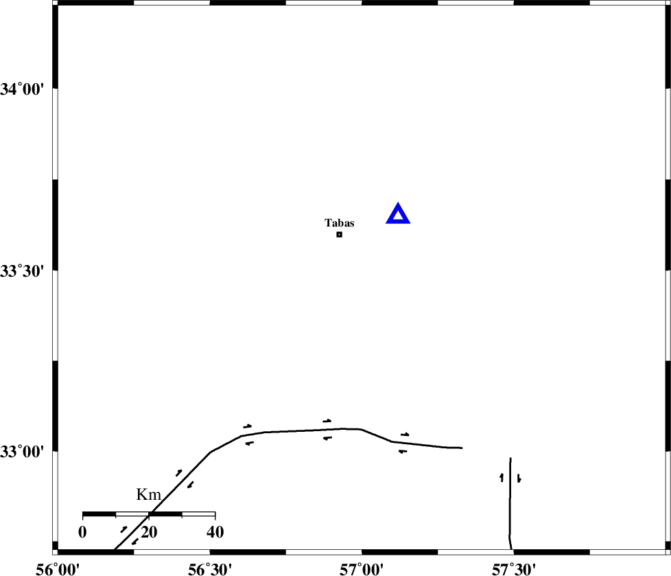
| Location | Lat:33.477 Lon: 56.999 |
| Region | Yazd Province, 15 km South of Tabas |
Nearest Cities |
|
| 7 km North of Kerit, Yazd Province | |
| 12 km of Oshtoqran, Yazd Province | |
| 15 km South of Tabas, Yazd Province | |
| 34 km South East of Jokhvah, Yazd Province | |
| 43 km South West of Arsak, Khorasan(center) Province | |
| Depth | 10 km |
| Agency | |
Faults within 150 km: |
|
| TABAS_F2 (Length: 67 km) , Distance to epicenter: 4 km | |
| TABAS_F1 (Length: 91 km) , Distance to epicenter: 9 km | |
| ESFARDIAR_F (Length: 94 km) , Distance to epicenter: 37 km | |
| Number of Phases | 11 |
| RMS | 0.1 |
| Number of Stations | 11 |
| Error in Latitude | >0.6 km |
| Error in Longitude | 0.6 km |
| Error in Depth | 1 km |
Download waveform in seisan format
to download seisan software Click here
to access information about IIEES stations Click here
Amplitude | ||||||||
| UID | Agency | Station | Component | Amplitude | Period | Arrival Time | Proccessing Time | Signal Clip |
| 197254 | IIEES SC | SHRO | Z | 0.08 | 1 | 2025-02-21 09:09:56 | 2025-02-23 06:55:00 | n |
| 197255 | IIEES SC | SHRT | Z | 0.08 | 1 | 2025-02-21 09:09:57 | 2025-02-23 06:55:00 | n |
| 197256 | IIEES SC | BJRD | Z | 0.01 | 1 | 2025-02-21 09:10:17 | 2025-02-23 06:55:00 | n |
Phase | ||||||||||||
| Agency | Station | Component | Phase Type | Phase Quality | First Motion | Observed Arrival Time | Time Residual | Loc. Flag | Input Weight | Distance | Azimuth | |
| IIEES SC | TABS | Z | EPg | E | 2025-02-21 09:09:15 | 0 | y | 0 | 22 | 30 | ||
| IIEES SC | YZKH | Z | EPn | E | 2025-02-21 09:09:51 | 0 | y | 0 | 255 | 242 | ||
| IIEES SC | BSRN | Z | EPn | E | 2025-02-21 09:09:37 | -14.5 | n | 4 | 260 | 130 | ||
| IIEES SC | SHRO | Z | EPn | E | 2025-02-21 09:09:56 | 0.2 | y | 0 | 295 | 342 | ||
| IIEES SC | SHRT | Z | EPn | E | 2025-02-21 09:09:57 | -0.1 | y | 0 | 306 | 86 | ||
| IIEES SC | KRBR | Z | EPn | E | 2025-02-21 09:10:18 | 10.3 | n | 4 | 388 | 183 | ||
| IIEES SC | NASN | Z | EPn | E | 2025-02-21 09:10:27 | 18 | n | 4 | 398 | 259 | ||
| IIEES SC | ABGH | Z | EPn | E | 2025-02-21 09:10:10 | 0 | y | 0 | 413 | 331 | ||
| IIEES SC | KAGH | Z | EPn | E | 2025-02-21 09:10:17 | 0.1 | y | 0 | 469 | 35 | ||
| IIEES SC | BJRD | Z | EPn | E | 2025-02-21 09:10:17 | -0.2 | y | 0 | 470 | 5 | ||
| IIEES SC | DAMV | Z | EPn | E | 2025-02-21 09:10:24 | 0 | y | 0 | 520 | 297 | ||