
Magnitude |
:2.9 |
| Date & Time (UTC) | 2019-12-10 08:27:12.7 |
| Date & Time (Local) | 1398/9/19 11:57:12.7 |
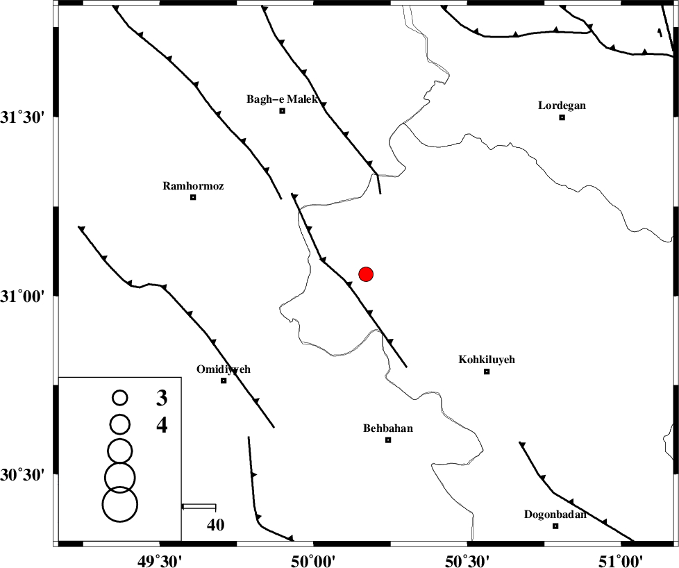
| Location | Lat:31.06 Lon: 50.17 |
| Region | Kohkiluieh va boyerahmad Province, 52 km North of Behbahan |
Nearest Cities |
|
| 26 km North West of Lendeh, Kohkiluieh va boyerahmad Province | |
| 27 km South West of Esfandan, Kohkiluieh va boyerahmad Province | |
| 29 km South West of Qale-ye raiesi, Kohkiluieh va boyerahmad Province | |
| 34 km South West of Dishmuk, Kohkiluieh va boyerahmad Province | |
| 34 km South of Seidun, Khoozestan Province | |
| Depth | 14 km |
| Agency | |
Faults within 150 km: |
|
| MFF4 (Length: 62 km) , Distance to epicenter: 7 km | |
| MFF2 (Length: 205 km) , Distance to epicenter: 25 km | |
| DEZFUL_EMBAYMENT (Length: 228 km) , Distance to epicenter: 35 km | |
| Number of Phases | 5 |
| RMS | 0.5 |
| Number of Stations | 5 |
| Error in Latitude | >0 km |
| Error in Longitude | 0 km |
| Error in Depth | 19 km |
Download waveform in seisan format
to download seisan software Click here
to access information about IIEES stations Click here
Amplitude | ||||||||
| UID | Agency | Station | Component | Amplitude | Period | Arrival Time | Proccessing Time | Signal Clip |
| 149622 | IIEES SC | KLNJ | Z | 380 | 1 | 2019-12-10 08:27:56 | 2019-12-11 03:01:00 | n |
| 149623 | IIEES SC | GTMR | Z | 130 | 1 | 2019-12-10 08:28:26 | 2019-12-11 03:01:00 | n |
| 149624 | IIEES SC | NASN | Z | 12 | 1 | 2019-12-10 08:28:40 | 2019-12-11 03:01:00 | n |
Phase | ||||||||||||
| Agency | Station | Component | Phase Type | Phase Quality | First Motion | Observed Arrival Time | Time Residual | Loc. Flag | Input Weight | Distance | Azimuth | |
| IIEES SC | KLNJ | N | IS | I | 2019-12-10 08:27:53 | 0.7 | y | 133 | 92 | |||
| IIEES SC | KLNJ | Z | IP | I | 2019-12-10 08:27:35 | -0.3 | y | 133 | 92 | |||
| IIEES SC | GTMR | N | IS | I | 2019-12-10 08:28:05 | 0.1 | y | 189 | 327 | |||
| IIEES SC | GTMR | Z | IP | I | 2019-12-10 08:27:43 | 0.1 | y | 189 | 327 | |||
| IIEES SC | NASN | Z | IP | I | 2019-12-10 08:27:58 | -0.9 | y | 311 | 52 | |||