
Magnitude |
:2.7 |
| Date & Time (UTC) | 2019-12-02 14:59:23.8 |
| Date & Time (Local) | 1398/9/11 18:29:23.8 |
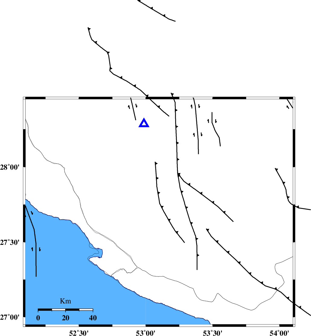
| Location | Lat:27.7 Lon: 53.1 |
| Region | Fars Province, 27 km North-East of Mehr |
Nearest Cities |
|
| 16 km North East of Alamarvdasht, Fars Province | |
| 27 km North East of Mehr, Fars Province | |
| 31 km North East of Khoozi, Fars Province | |
| 32 km North East of Ardavan-e olia, Fars Province | |
| 37 km South West of Khonj, Fars Province | |
| Depth | 10 km |
| Agency | |
Faults within 150 km: |
|
| MFF3 (Length: 292 km) , Distance to epicenter: 44 km | |
| QIR_F (Length: 130 km) , Distance to epicenter: 67 km | |
| LAR_F (Length: 99 km) , Distance to epicenter: 77 km | |
| Number of Phases | 6 |
| RMS | 1.2 |
| Number of Stations | 6 |
| Error in Latitude | >5 km |
| Error in Longitude | 0 km |
| Error in Depth | 4 km |
Download waveform in seisan format
to download seisan software Click here
to access information about IIEES stations Click here
Amplitude | ||||||||
| UID | Agency | Station | Component | Amplitude | Period | Arrival Time | Proccessing Time | Signal Clip |
| 149223 | IIEES SC | LMD1 | Z | 1100 | 1 | 2019-12-02 14:59:42 | 2019-12-03 08:22:00 | n |
| 149224 | IIEES SC | GHIR | Z | 61 | 1 | 2019-12-02 14:59:49 | 2019-12-03 08:22:00 | n |
| 149225 | IIEES SC | KLNJ | Z | 14 | 1 | 2019-12-02 15:01:31 | 2019-12-03 08:22:00 | n |
| 149226 | IIEES SC | KRBR | Z | 9.6 | 1 | 2019-12-02 15:02:01 | 2019-12-03 08:22:00 | n |
Phase | ||||||||||||
| Agency | Station | Component | Phase Type | Phase Quality | First Motion | Observed Arrival Time | Time Residual | Loc. Flag | Input Weight | Distance | Azimuth | |
| IIEES SC | LMD1 | N | IS | I | 2019-12-02 14:59:36 | 0.1 | y | 44 | 171 | |||
| IIEES SC | LMD1 | Z | IP | I | 2019-12-02 14:59:30 | -0.9 | y | 44 | 171 | |||
| IIEES SC | GHIR | N | IS | I | 2019-12-02 14:59:42 | -1.4 | y | 66 | 350 | |||
| IIEES SC | GHIR | Z | IP | I | 2019-12-02 14:59:34 | -1.5 | y | 66 | 350 | |||
| IIEES SC | KLNJ | Z | IP | I | 2019-12-02 15:00:22 | 1.5 | y | 400 | 338 | |||
| IIEES SC | KRBR | Z | IP | I | 2019-12-02 15:00:27 | 1.3 | y | 433 | 55 | |||