
Magnitude |
:2.6 |
| Date & Time (UTC) | 2019-09-03 10:44:12.1 |
| Date & Time (Local) | 1398/6/12 15:14:12.1 |
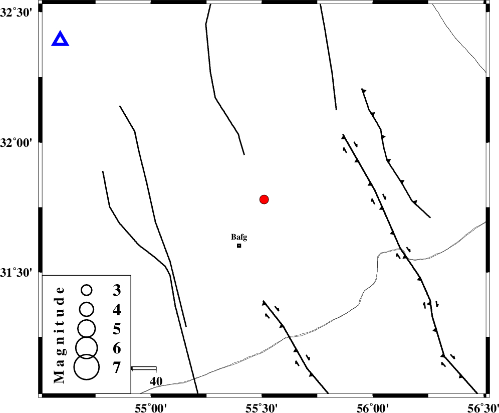
| Location | Lat:31.78 Lon: 55.51 |
| Region | Yazd Province, 22 km North-East of Bafq |
Nearest Cities |
|
| 19 km North of Mobarake, Yazd Province | |
| 22 km North East of Bafq, Yazd Province | |
| 26 km North West of Kushk, Yazd Province | |
| 50 km West of Behabad, Yazd Province | |
| 54 km North West of Benestan, Yazd Province | |
| Depth | 5 km |
| Agency | |
Faults within 150 km: |
|
| POSHT_E_BADAM_F (Length: 128 km) , Distance to epicenter: 21 km | |
| DARIVAN_F (Length: 131 km) , Distance to epicenter: 43 km | |
| KUHBANAN_F (Length: 189 km) , Distance to epicenter: 44 km | |
| Number of Phases | 4 |
| RMS | 0.2 |
| Number of Stations | 4 |
| Error in Latitude | >0 km |
| Error in Longitude | 0 km |
| Error in Depth | 0 km |
Download waveform in seisan format
to download seisan software Click here
to access information about IIEES stations Click here
Amplitude | ||||||||
| UID | Agency | Station | Component | Amplitude | Period | Arrival Time | Proccessing Time | Signal Clip |
| 146050 | IIEES SC | YZKH | Z | 35 | 1 | 2019-09-03 10:44:53 | 2019-10-02 07:58:00 | n |
| 146051 | IIEES SC | KRBR | Z | 55 | 1 | 2019-09-03 10:45:29 | 2019-10-02 07:58:00 | n |
| 146052 | IIEES SC | TABS | Z | 32 | 1 | 2019-09-03 10:45:35 | 2019-10-02 07:58:00 | n |
| 146053 | IIEES SC | BSRN | Z | 12 | 1 | 2019-09-03 10:45:54 | 2019-10-02 07:58:00 | n |
Phase | ||||||||||||
| Agency | Station | Component | Phase Type | Phase Quality | First Motion | Observed Arrival Time | Time Residual | Loc. Flag | Input Weight | Distance | Azimuth | |
| IIEES SC | YZKH | Z | IP | I | 2019-09-03 10:44:31 | -0.1 | y | 111 | 308 | |||
| IIEES SC | KRBR | Z | IP | I | 2019-09-03 10:44:50 | 0.2 | y | 233 | 149 | |||
| IIEES SC | TABS | Z | IP | I | 2019-09-03 10:44:52 | 0.2 | y | 255 | 36 | |||
| IIEES SC | BSRN | Z | IP | I | 2019-09-03 10:45:03 | -0.4 | y | 344 | 87 | |||