
Magnitude |
:3.5 |
| Date & Time (UTC) | 2019-03-09 07:58:08.5 |
| Date & Time (Local) | 1397/12/18 11:28:08.5 |
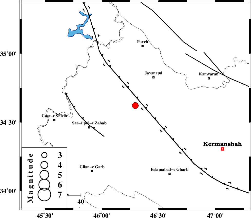
| Location | Lat:34.622 Lon: 46.295 |
| Region | Kermanshah Province, 27 km South-West of Javanrud |
Nearest Cities |
|
| 7 km of Mirabad, Kermanshah Province | |
| 14 km North of Zavleh olia, Kermanshah Province | |
| 17 km South East of Qolqoleh, Kermanshah Province | |
| 17 km West of Dolatabad, Kermanshah Province | |
| 21 km South West of Sarukhan, Kermanshah Province | |
| Depth | 15 km |
| Agency | |
Faults within 150 km: |
|
| HZF4 (Length: 492 km) , Distance to epicenter: 11 km | |
| MFF8 (Length: 48 km) , Distance to epicenter: 35 km | |
| SARTAKHT_F (Length: 78 km) , Distance to epicenter: 58 km | |
| Number of Phases | 8 |
| RMS | 0.5 |
| Number of Stations | 6 |
| Error in Latitude | >3.7 km |
| Error in Longitude | 4.7 km |
| Error in Depth | 7.6 km |
Download waveform in seisan format
to download seisan software Click here
to access information about IIEES stations Click here
Amplitude | ||||||||
| UID | Agency | Station | Component | Amplitude | Period | Arrival Time | Proccessing Time | Signal Clip |
| 141530 | IIEES | SNGE | N | 622.7 | 0.32 | 2019-03-09 07:58:43 | 2019-03-09 10:50:00 | n |
| 141531 | IIEES | ILBA | E | 1670.4 | 0.48 | 2019-03-09 07:58:48 | 2019-03-09 10:50:00 | n |
| 141532 | IIEES | ILBA | N | 1148.9 | 0.33 | 2019-03-09 07:58:48 | 2019-03-09 10:50:00 | n |
| 141533 | IIEES | SRSL | N | 549.5 | 0.47 | 2019-03-09 07:59:08 | 2019-03-09 10:50:00 | n |
| 141534 | IIEES | SRSL | E | 471.6 | 0.34 | 2019-03-09 07:59:08 | 2019-03-09 10:50:00 | n |
Phase | ||||||||||||
| Agency | Station | Component | Phase Type | Phase Quality | First Motion | Observed Arrival Time | Time Residual | Loc. Flag | Input Weight | Distance | Azimuth | |
| IIEES | SNGE | Z | EPg | E | 2019-03-09 07:58:26 | -0.83 | y | 109 | 61 | |||
| IIEES | SNGE | N | ESg | E | 2019-03-09 07:58:40 | 0.04 | y | 109 | 61 | |||
| IIEES | ILBA | Z | EPg | E | 2019-03-09 07:58:27 | -0.07 | y | 111 | 184 | |||
| IIEES | SRSL | Z | EPg | E | 2019-03-09 07:58:39 | -0.71 | y | 193 | 336 | |||
| IIEES | SRSL | N | ESg | E | 2019-03-09 07:59:04 | 0.47 | y | 193 | 336 | |||
| IIEES | ZNJK | Z | EPn | E | 2019-03-09 07:58:55 | 0.54 | y | 314 | 43 | |||
| IIEES | KHMZ | Z | EPn | E | 2019-03-09 07:59:00 | 0.67 | y | 352 | 105 | |||
| IIEES | GRMI | Z | EPn | E | 2019-03-09 07:59:16 | 0.06 | y | 486 | 17 | |||