
Magnitude |
:3 |
| Date & Time (UTC) | 2019-01-13 08:51:07.5 |
| Date & Time (Local) | 1397/10/23 12:21:07.5 |
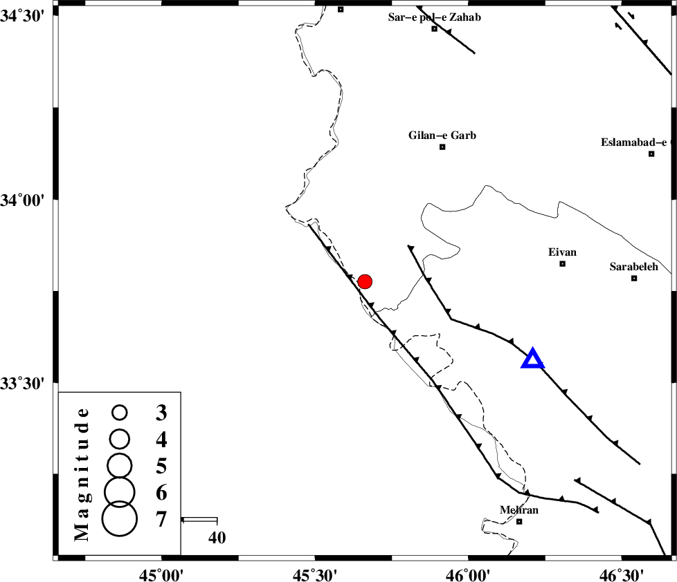
| Location | Lat:33.776 Lon: 45.662 |
| Region | Kermanshah Province, 47 km South-West of Gilan-E-Gharb |
Nearest Cities |
|
| 12 km South of Sumar, Kermanshah Province | |
| 39 km South West of Nian, Kermanshah Province | |
| 47 km South West of Teran, Ilam Province | |
| 47 km South West of Gilan-E-Gharb, Kermanshah Province | |
| 51 km South West of Zarneh, Ilam Province | |
| Depth | 14 km |
| Agency | |
Faults within 150 km: |
|
| ZFF4 (Length: 128 km) , Distance to epicenter: 12 km | |
| MFF7 (Length: 99 km) , Distance to epicenter: 17 km | |
| MFF8 (Length: 48 km) , Distance to epicenter: 76 km | |
| Number of Phases | 7 |
| RMS | 0.3 |
| Number of Stations | 5 |
| Error in Latitude | >3.6 km |
| Error in Longitude | 5.8 km |
| Error in Depth | 6.9 km |
Download waveform in seisan format
to download seisan software Click here
to access information about IIEES stations Click here
Amplitude | ||||||||
| UID | Agency | Station | Component | Amplitude | Period | Arrival Time | Proccessing Time | Signal Clip |
| 140114 | IIEES | ILBA | E | 700 | 0.33 | 2019-01-13 08:51:26 | 2019-01-14 06:29:00 | n |
| 140115 | IIEES | SNGE | N | 100.8 | 0.54 | 2019-01-13 08:52:15 | 2019-01-14 06:29:00 | n |
| 140116 | IIEES | SRSL | N | 105.7 | 0.37 | 2019-01-13 08:52:30 | 2019-01-14 06:29:00 | n |
| 140117 | IIEES | SRSL | E | 52.7 | 0.37 | 2019-01-13 08:52:35 | 2019-01-14 06:29:00 | n |
Phase | ||||||||||||
| Agency | Station | Component | Phase Type | Phase Quality | First Motion | Observed Arrival Time | Time Residual | Loc. Flag | Input Weight | Distance | Azimuth | |
| IIEES | ILBA | Z | Pg | E | 2019-01-13 08:51:16 | -0.45 | y | 53.3 | 108 | |||
| IIEES | SNGE | Z | Pn | E | 2019-01-13 08:51:42 | 0.28 | y | 213 | 46 | |||
| IIEES | SNGE | N | Sg | E | 2019-01-13 08:52:08 | 0.06 | y | 213 | 46 | |||
| IIEES | SRSL | Z | Pn | E | 2019-01-13 08:51:49 | 0.26 | y | 271 | 356 | |||
| IIEES | SRSL | N | Sg | E | 2019-01-13 08:52:23 | -0.37 | y | 271 | 356 | |||
| IIEES | ASAO | Z | Pn | E | 2019-01-13 08:52:06 | 0.22 | y | 411 | 77 | |||
| IIEES | ZNJK | Z | Pn | E | 2019-01-13 08:52:08 | 0.05 | y | 423 | 40 | |||