
Magnitude |
:3.6 |
| Date & Time (UTC) | 2018-11-30 08:28:20.0 |
| Date & Time (Local) | 1397/9/9 11:58:20.0 |
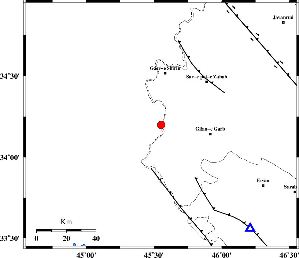
| Location | Lat:34.199 Lon: 45.553 |
| Region | Iraq, 35 km South of Qasr-E-Shirin |
Nearest Cities |
|
| 24 km South of Khosravi, Kermanshah Province | |
| 28 km South of Seyyed sohrab, Kermanshah Province | |
| 31 km South West of Chub baghan, Kermanshah Province | |
| 34 km North West of Gilan-E-Gharb, Kermanshah Province | |
| 35 km South of Qasr-E-Shirin, Kermanshah Province | |
| Depth | 14 km |
| Agency | |
Faults within 150 km: |
|
| ZFF4 (Length: 128 km) , Distance to epicenter: 30 km | |
| MFF7 (Length: 99 km) , Distance to epicenter: 43 km | |
| MFF8 (Length: 48 km) , Distance to epicenter: 44 km | |
| Number of Phases | 8 |
| RMS | 0.2 |
| Number of Stations | 6 |
| Error in Latitude | >2 km |
| Error in Longitude | 3.5 km |
| Error in Depth | 4.5 km |
Download waveform in seisan format
to download seisan software Click here
to access information about IIEES stations Click here
Amplitude | ||||||||
| UID | Agency | Station | Component | Amplitude | Period | Arrival Time | Proccessing Time | Signal Clip |
| 138855 | IIEES | SNGE | N | 605.5 | 0.65 | 2018-11-30 08:29:18 | 2018-12-01 12:04:00 | n |
| 138856 | IIEES | SNGE | E | 576.7 | 0.53 | 2018-11-30 08:29:21 | 2018-12-01 12:04:00 | n |
| 138857 | IIEES | SRSL | N | 466.1 | 0.6 | 2018-11-30 08:29:25 | 2018-12-01 12:04:00 | n |
| 138858 | IIEES | SRSL | E | 421.5 | 0.52 | 2018-11-30 08:29:27 | 2018-12-01 12:04:00 | n |
| 138859 | IIEES | GHVR | E | 22.6 | 0.55 | 2018-11-30 08:30:30 | 2018-12-01 12:04:00 | n |
Phase | ||||||||||||
| Agency | Station | Component | Phase Type | Phase Quality | First Motion | Observed Arrival Time | Time Residual | Loc. Flag | Input Weight | Distance | Azimuth | |
| IIEES | ILBA | Z | Pg | E | 2018-11-30 08:28:35 | -0.01 | y | 87.9 | 136 | |||
| IIEES | SNGE | Z | Pg | E | 2018-11-30 08:28:51 | -0.3 | y | 192 | 58 | |||
| IIEES | SNGE | N | Sg | E | 2018-11-30 08:29:15 | 0.2 | y | 192 | 58 | |||
| IIEES | SRSL | Z | Pn | E | 2018-11-30 08:28:55 | 0.32 | y | 224 | 357 | |||
| IIEES | SRSL | N | Sg | E | 2018-11-30 08:29:23 | -0.17 | y | 224 | 357 | |||
| IIEES | KHMZ | Z | Pn | E | 2018-11-30 08:29:18 | -0.09 | y | 411 | 96 | |||
| IIEES | ASAO | Z | Pn | E | 2018-11-30 08:29:19 | 0.1 | y | 413 | 83 | |||
| IIEES | GHVR | Z | Pn | E | 2018-11-30 08:29:32 | -0.08 | y | 525 | 85 | |||