
Magnitude |
:2.7 |
| Date & Time (UTC) | 2017-10-05 13:16:05.2 |
| Date & Time (Local) | 1396/7/13 16:46:05.2 |
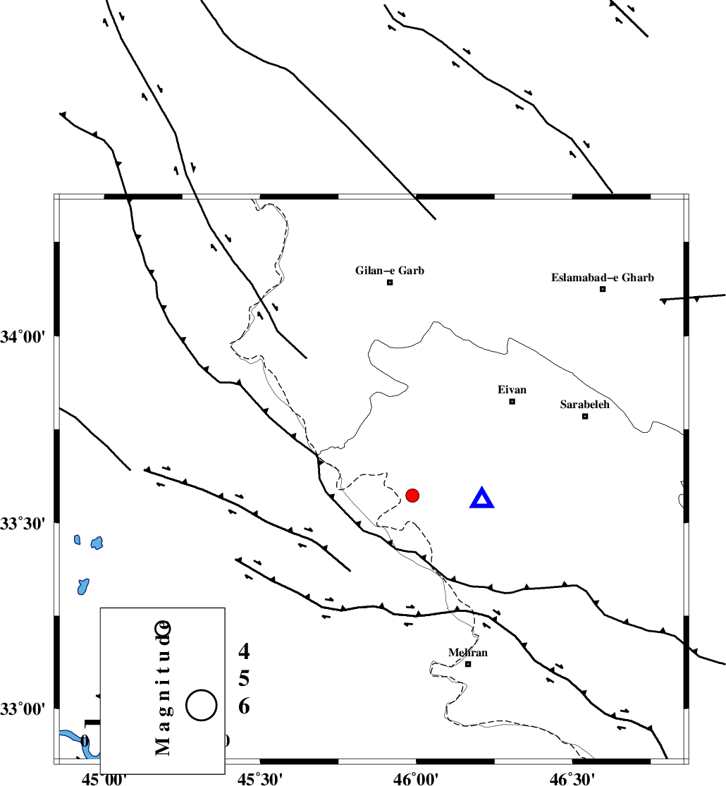
| Location | Lat:33.614 Lon: 45.856 |
| Region | Ilam Province, 59 km South of Gilan-E-Gharb |
Nearest Cities |
|
| 35 km North West of Salehabad, Ilam Province | |
| 36 km South East of Sumar, Kermanshah Province | |
| 39 km West of Chavar, Ilam Province | |
| 45 km South West of Teran, Ilam Province | |
| 46 km South West of Zarneh, Ilam Province | |
| Depth | 14 km |
| Agency | |
Faults within 150 km: |
|
| MFF7 (Length: 99 km) , Distance to epicenter: 11 km | |
| ZFF4 (Length: 128 km) , Distance to epicenter: 12 km | |
| MFF6 (Length: 144 km) , Distance to epicenter: 62 km | |
| Number of Phases | 7 |
| RMS | 0.4 |
| Number of Stations | 4 |
| Error in Latitude | >6.1 km |
| Error in Longitude | 9.4 km |
| Error in Depth | 6.9 km |
Download waveform in seisan format
to download seisan software Click here
to access information about IIEES stations Click here
Amplitude | ||||||||
| UID | Agency | Station | Component | Amplitude | Period | Arrival Time | Proccessing Time | Signal Clip |
| 120258 | IIEES | SNGE | N | 115.2 | 0.5 | 2017-10-05 13:17:13 | 2017-10-07 11:45:00 | n |
| 120259 | IIEES | SNGE | E | 83.9 | 0.43 | 2017-10-05 13:17:16 | 2017-10-07 11:45:00 | n |
| 120260 | IIEES | KHMZ | N | 7.7 | 0.23 | 2017-10-05 13:17:46 | 2017-10-07 11:45:00 | n |
| 120261 | IIEES | KHMZ | E | 9.7 | 0.47 | 2017-10-05 13:17:50 | 2017-10-07 11:45:00 | n |
| 120262 | IIEES | ASAO | N | 7.3 | 0.52 | 2017-10-05 13:18:07 | 2017-10-07 11:45:00 | n |
| 120263 | IIEES | ASAO | E | 7.6 | 0.63 | 2017-10-05 13:18:10 | 2017-10-07 11:45:00 | n |
Phase | ||||||||||||
| Agency | Station | Component | Phase Type | Phase Quality | First Motion | Observed Arrival Time | Time Residual | Loc. Flag | Input Weight | Distance | Azimuth | |
| IIEES | ILBA | Z | Pg | E | 2017-10-05 13:16:10 | -0.58 | y | 32.6 | 88 | |||
| IIEES | ILBA | N | Sg | E | 2017-10-05 13:16:16 | 0.18 | y | 32.6 | 88 | |||
| IIEES | SNGE | Z | Pn | E | 2017-10-05 13:16:39 | -0.33 | y | 214 | 40 | |||
| IIEES | SNGE | N | Sg | E | 2017-10-05 13:17:06 | 0.12 | y | 214 | 40 | |||
| IIEES | KHMZ | Z | Pn | E | 2017-10-05 13:17:01 | 0.77 | y | 381 | 87 | |||
| IIEES | KHMZ | N | S | E | 2017-10-05 13:17:40 | -0.31 | y | 381 | 87 | |||
| IIEES | ASAO | Z | Pn | E | 2017-10-05 13:17:02 | 0.3 | y | 399 | 74 | |||