
Magnitude |
:2.6 |
| Date & Time (UTC) | 2017-09-24 22:30:16.2 |
| Date & Time (Local) | 1396/7/3 02:00:16.2 |
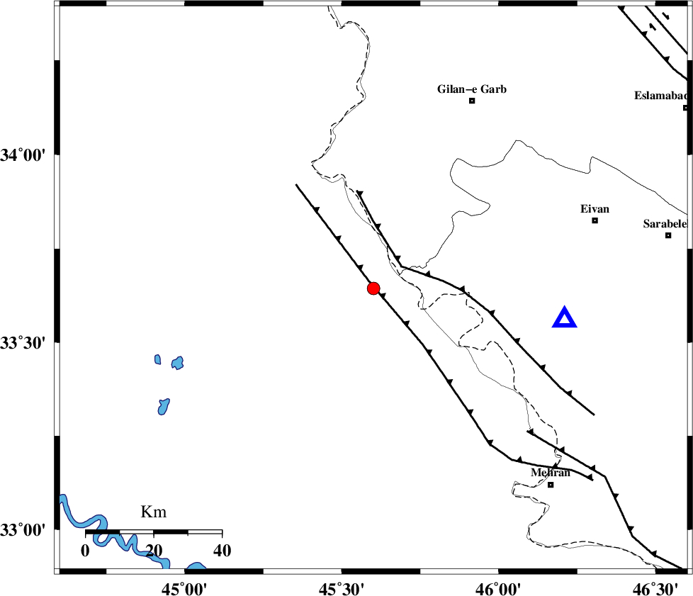
| Location | Lat:33.644 Lon: 45.601 |
| Region | Iraq, 63 km South-West of Gilan-E-Gharb |
Nearest Cities |
|
| 26 km South of Sumar, Kermanshah Province | |
| 54 km South West of Nian, Kermanshah Province | |
| 58 km North West of Salehabad, Ilam Province | |
| 59 km South West of Teran, Ilam Province | |
| 62 km West of Chavar, Ilam Province | |
| Depth | 16 km |
| Agency | |
Faults within 150 km: |
|
| ZFF4 (Length: 128 km) , Distance to epicenter: 11 km | |
| MFF7 (Length: 99 km) , Distance to epicenter: 29 km | |
| MFF6 (Length: 144 km) , Distance to epicenter: 83 km | |
| Number of Phases | 5 |
| RMS | 0 |
| Number of Stations | 3 |
| Error in Latitude | >4.2 km |
| Error in Longitude | 4.6 km |
| Error in Depth | 4.6 km |
Download waveform in seisan format
to download seisan software Click here
to access information about IIEES stations Click here
Amplitude | ||||||||
| UID | Agency | Station | Component | Amplitude | Period | Arrival Time | Proccessing Time | Signal Clip |
| 119936 | IIEES | SNGE | N | 51.5 | 0.42 | 2017-09-24 22:31:25 | 2017-09-25 08:13:00 | n |
| 119937 | IIEES | SNGE | E | 43.9 | 0.66 | 2017-09-24 22:31:27 | 2017-09-25 08:13:00 | n |
| 119938 | IIEES | KHMZ | E | 10 | 0.57 | 2017-09-24 22:31:59 | 2017-09-25 08:13:00 | n |
| 119939 | IIEES | KHMZ | N | 6.8 | 0.42 | 2017-09-24 22:32:01 | 2017-09-25 08:13:00 | n |
| 119940 | IIEES | ASAO | E | 6.4 | 0.71 | 2017-09-24 22:32:05 | 2017-09-25 08:13:00 | n |
| 119941 | IIEES | ASAO | N | 8.3 | 0.51 | 2017-09-24 22:32:05 | 2017-09-25 08:13:00 | n |
Phase | ||||||||||||
| Agency | Station | Component | Phase Type | Phase Quality | First Motion | Observed Arrival Time | Time Residual | Loc. Flag | Input Weight | Distance | Azimuth | |
| IIEES | SNGE | Z | Pn | E | 2017-09-24 22:30:52 | 0 | y | 227 | 44 | |||
| IIEES | SNGE | N | Sg | E | 2017-09-24 22:31:20 | 0 | y | 227 | 44 | |||
| IIEES | KHMZ | Z | Pn | E | 2017-09-24 22:31:14 | 0 | y | 405 | 87 | |||
| IIEES | ASAO | Z | Pn | E | 2017-09-24 22:31:16 | 0 | y | 420 | 75 | |||
| IIEES | ASAO | N | S | E | 2017-09-24 22:32:00 | 0 | y | 420 | 75 | |||