
Magnitude |
:2.5 |
| Date & Time (UTC) | 2017-08-28 20:48:33.6 |
| Date & Time (Local) | 1396/6/7 01:18:33.6 |
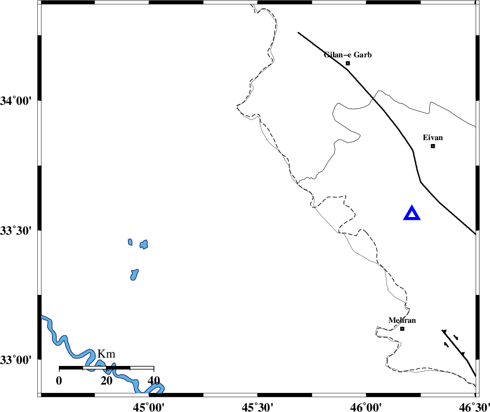
| Location | Lat:33.619 Lon: 45.504 |
| Region | Iraq, 70 km South-West of Gilan-E-Gharb |
Nearest Cities |
|
| 32 km South West of Sumar, Kermanshah Province | |
| 62 km South West of Nian, Kermanshah Province | |
| 65 km North West of Salehabad, Ilam Province | |
| 68 km South West of Teran, Ilam Province | |
| 70 km South West of Gilan-E-Gharb, Kermanshah Province | |
| Depth | 16 km |
| Agency | |
Faults within 150 km: |
|
| ZFF4 (Length: 128 km) , Distance to epicenter: 20 km | |
| MFF7 (Length: 99 km) , Distance to epicenter: 38 km | |
| MFF6 (Length: 144 km) , Distance to epicenter: 89 km | |
| Number of Phases | 6 |
| RMS | 0 |
| Number of Stations | 4 |
| Error in Latitude | >1.8 km |
| Error in Longitude | 4.3 km |
| Error in Depth | 4.2 km |
Download waveform in seisan format
to download seisan software Click here
to access information about IIEES stations Click here
Amplitude | ||||||||
| UID | Agency | Station | Component | Amplitude | Period | Arrival Time | Proccessing Time | Signal Clip |
| 119101 | IIEES | SNGE | N | 38.8 | 0.49 | 2017-08-28 20:49:43 | 2017-08-29 06:19:00 | n |
| 119102 | IIEES | SNGE | E | 35.9 | 0.33 | 2017-08-28 20:49:44 | 2017-08-29 06:19:00 | n |
| 119103 | IIEES | KHMZ | E | 4.6 | 0.62 | 2017-08-28 20:50:35 | 2017-08-29 06:19:00 | n |
| 119104 | IIEES | ASAO | N | 4.7 | 0.39 | 2017-08-28 20:50:26 | 2017-08-29 06:19:00 | n |
| 119105 | IIEES | ASAO | E | 3.3 | 0.55 | 2017-08-28 20:50:46 | 2017-08-29 06:19:00 | n |
Phase | ||||||||||||
| Agency | Station | Component | Phase Type | Phase Quality | First Motion | Observed Arrival Time | Time Residual | Loc. Flag | Input Weight | Distance | Azimuth | |
| IIEES | ILBA | Z | Pg | E | 2017-08-28 20:48:45 | 0 | y | 65.2 | 89 | |||
| IIEES | ILBA | E | Sg | E | 2017-08-28 20:48:53 | 0 | y | 65.2 | 89 | |||
| IIEES | SNGE | Z | Pn | E | 2017-08-28 20:49:10 | -0.01 | y | 236 | 46 | |||
| IIEES | SNGE | N | Sg | E | 2017-08-28 20:49:40 | 0 | y | 236 | 46 | |||
| IIEES | KHMZ | Z | Pn | E | 2017-08-28 20:49:32 | -0.01 | y | 414 | 87 | |||
| IIEES | ASAO | Z | Pn | E | 2017-08-28 20:49:34 | 0.02 | y | 430 | 75 | |||