
Magnitude |
:2.2 |
| Date & Time (UTC) | 2017-06-19 01:47:46.1 |
| Date & Time (Local) | 1396/3/29 06:17:46.1 |
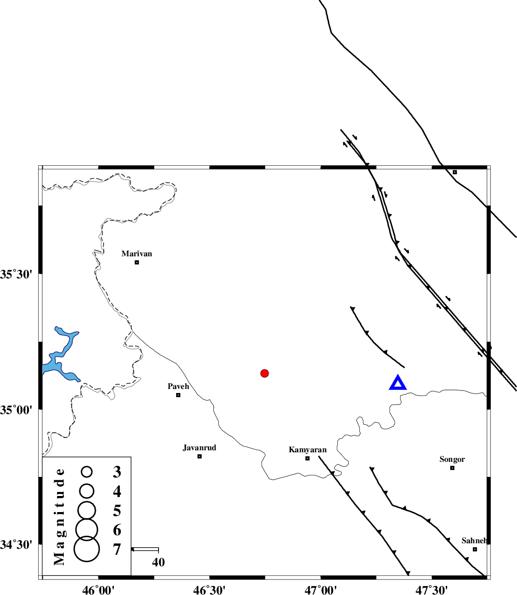
| Location | Lat:35.133 Lon: 46.747 |
| Region | Kurdistan Province, 31 km South-West of Sanandaj |
Nearest Cities |
|
| 8 km of Turivar, Kurdistan Province | |
| 16 km South East of Bisaran, Kurdistan Province | |
| 16 km South of Avihang, Kurdistan Province | |
| 16 km East of Baygalan, Kurdistan Province | |
| 19 km West of Ali Abad, Kurdistan Province | |
| Depth | 7 km |
| Agency | |
Faults within 150 km: |
|
| PIRANSHAHR_F (Length: 253 km) , Distance to epicenter: 6 km | |
| SARTAKHT_F (Length: 78 km) , Distance to epicenter: 15 km | |
| MORVARID_F (Length: 24 km) , Distance to epicenter: 19 km | |
| Number of Phases | 7 |
| RMS | 0.4 |
| Number of Stations | 5 |
| Error in Latitude | >6.4 km |
| Error in Longitude | 6.1 km |
| Error in Depth | 8.8 km |
Download waveform in seisan format
to download seisan software Click here
to access information about IIEES stations Click here
Amplitude | ||||||||
| UID | Agency | Station | Component | Amplitude | Period | Arrival Time | Proccessing Time | Signal Clip |
| 116855 | IIEES | SNGE | E | 171.8 | 0.41 | 2017-06-19 01:48:06 | 2017-06-19 05:57:00 | n |
| 116856 | IIEES | SNGE | N | 132.2 | 0.41 | 2017-06-19 01:48:06 | 2017-06-19 05:57:00 | n |
| 116857 | IIEES | ILBA | N | 36 | 0.38 | 2017-06-19 01:48:42 | 2017-06-19 05:57:00 | n |
| 116858 | IIEES | ILBA | E | 39.5 | 0.51 | 2017-06-19 01:48:42 | 2017-06-19 05:57:00 | n |
| 116859 | IIEES | KHMZ | N | 5.6 | 0.41 | 2017-06-19 01:49:31 | 2017-06-19 05:57:00 | n |
| 116860 | IIEES | KHMZ | E | 4.4 | 0.51 | 2017-06-19 01:49:36 | 2017-06-19 05:57:00 | n |
Phase | ||||||||||||
| Agency | Station | Component | Phase Type | Phase Quality | First Motion | Observed Arrival Time | Time Residual | Loc. Flag | Input Weight | Distance | Azimuth | |
| IIEES | SNGE | Z | Pg | E | 2017-06-19 01:47:55 | -0.37 | y | 54.9 | 95 | |||
| IIEES | SNGE | N | Sg | E | 2017-06-19 01:48:03 | 0.31 | y | 54.9 | 95 | |||
| IIEES | ILBA | Z | Pg | E | 2017-06-19 01:48:15 | -0.39 | y | 175 | 197 | |||
| IIEES | ILBA | E | Sg | E | 2017-06-19 01:48:38 | 0.43 | y | 175 | 197 | |||
| IIEES | ZNJK | Z | Pn | E | 2017-06-19 01:48:25 | 0.46 | y | 244 | 45 | |||
| IIEES | ASAO | Z | Pn | E | 2017-06-19 01:48:32 | -0.13 | y | 307 | 101 | |||
| IIEES | KHMZ | Z | Pn | E | 2017-06-19 01:48:35 | -0.37 | y | 334 | 117 | |||