
Magnitude |
:2.8 |
| Date & Time (UTC) | 2017-03-27 15:34:51.5 |
| Date & Time (Local) | 1396/1/7 20:04:51.5 |
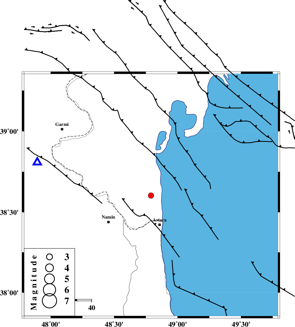
| Location | Lat:38.603 Lon: 48.79 |
| Region | Azerbaijan, 21 km North of Astara |
Nearest Cities |
|
| 21 km North of Astara, Gilan Province | |
| 28 km North East of Kiladeh, Gilan Province | |
| 31 km North East of Anbaran, Ardebil Province | |
| 33 km North of Londovil, Gilan Province | |
| 34 km North East of Namin, Ardebil Province | |
| Depth | 20 km |
| Agency | |
Faults within 150 km: |
|
| TALESH_F (Length: 258 km) , Distance to epicenter: 1 km | |
| SANGAVAR_F (Length: 61 km) , Distance to epicenter: 48 km | |
| BOZQUSH (Length: 70 km) , Distance to epicenter: 65 km | |
| Number of Phases | 8 |
| RMS | 0.4 |
| Number of Stations | 8 |
| Error in Latitude | >9.7 km |
| Error in Longitude | 3.6 km |
| Error in Depth | 0 km |
Download waveform in seisan format
to download seisan software Click here
to access information about IIEES stations Click here
Amplitude | ||||||||
| UID | Agency | Station | Component | Amplitude | Period | Arrival Time | Proccessing Time | Signal Clip |
| 114566 | IIEES | GIDE | E | 63.2 | 0.33 | 2017-03-27 15:35:49 | 2017-04-05 06:16:00 | n |
| 114567 | IIEES | THKV | E | 21 | 0.49 | 2017-03-27 15:36:24 | 2017-04-05 06:16:00 | n |
Phase | ||||||||||||
| Agency | Station | Component | Phase Type | Phase Quality | First Motion | Observed Arrival Time | Time Residual | Loc. Flag | Input Weight | Distance | Azimuth | |
| IIEES | GIDE | Z | Pn | E | 2017-03-27 15:35:24 | -0.36 | y | 211 | 152 | |||
| IIEES | ZNJK | Z | Pn | E | 2017-03-27 15:35:25 | 0.06 | y | 215 | 183 | |||
| IIEES | THKV | Z | Pn | E | 2017-03-27 15:35:43 | 1.02 | y | 351 | 148 | |||
| IIEES | CHTH | Z | Pn | E | 2017-03-27 15:35:43 | -0.14 | y | 364 | 145 | |||
| IIEES | MAKU | Z | Pn | E | 2017-03-27 15:35:44 | -0.01 | y | 366 | 284 | |||
| IIEES | SNGE | Z | Pn | E | 2017-03-27 15:35:49 | 0.07 | y | 410 | 199 | |||
| IIEES | DAMV | Z | Pn | E | 2017-03-27 15:35:52 | -0.31 | y | 434 | 138 | |||
| IIEES | ASAO | Z | Pn | E | 2017-03-27 15:35:56 | -0.38 | y | 463 | 166 | |||