
Magnitude |
:2.7 |
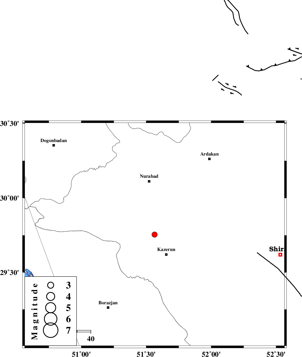
| Date & Time (UTC) | 2017-02-26 11:49:40.9 |
| Date & Time (Local) | 1395/12/8 15:19:40.9 |
| Location | Lat:29.754 Lon: 51.564 |
| Region | Fars Province, 17 km North of Kazerun |
Nearest Cities |
|
| 8 km of Seyyed hasan, Fars Province | |
| 9 km North of Deris, Fars Province | |
| 14 km West of Nodan, Fars Province | |
| 16 km North of Kamaraj, Fars Province | |
| 17 km North of Kazerun, Fars Province | |
| Depth | 14 km |
| Agency | |
Faults within 150 km: |
|
| KAZERUN_F (Length: 96 km) , Distance to epicenter: 6 km | |
| BORAZJAN_F (Length: 168 km) , Distance to epicenter: 39 km | |
| KAREBASS_F (Length: 98 km) , Distance to epicenter: 48 km | |
| Number of Phases | 6 |
| RMS | 0.1 |
| Number of Stations | 4 |
| Error in Latitude | >2.2 km |
| Error in Longitude | 2.3 km |
| Error in Depth | 6.3 km |
Download waveform in seisan format
to download seisan software Click here
to access information about IIEES stations Click here
Amplitude | ||||||||
| UID | Agency | Station | Component | Amplitude | Period | Arrival Time | Proccessing Time | Signal Clip |
| 113595 | IIEES | AHRM | N | 158.4 | 0.3 | 2017-02-26 11:50:17 | 2017-02-27 06:46:00 | n |
| 113596 | IIEES | GHIR | E | 61.5 | 0.56 | 2017-02-26 11:50:56 | 2017-02-27 06:46:00 | n |
| 113597 | IIEES | GHIR | N | 83.8 | 0.56 | 2017-02-26 11:50:59 | 2017-02-27 06:46:00 | n |
| 113598 | IIEES | YZKH | N | 6.5 | 0.26 | 2017-02-26 11:51:30 | 2017-02-27 06:46:00 | n |
Phase | ||||||||||||
| Agency | Station | Component | Phase Type | Phase Quality | First Motion | Observed Arrival Time | Time Residual | Loc. Flag | Input Weight | Distance | Azimuth | |
| IIEES | AHRM | Z | Pg | E | 2017-02-26 11:49:58 | -0.02 | y | 102 | 195 | |||
| IIEES | AHRM | N | Sg | E | 2017-02-26 11:50:10 | -0.01 | y | 102 | 195 | |||
| IIEES | GHIR | Z | Pn | E | 2017-02-26 11:50:15 | 0.04 | y | 214 | 139 | |||
| IIEES | GHIR | N | Sg | E | 2017-02-26 11:50:41 | 0.02 | y | 214 | 139 | |||
| IIEES | NASN | Z | Pn | E | 2017-02-26 11:50:33 | 0.16 | y | 358 | 19 | |||
| IIEES | YZKH | Z | Pn | E | 2017-02-26 11:50:39 | -0.22 | y | 411 | 44 | |||