
Magnitude |
:3 |
| Date & Time (UTC) | 2017-02-02 07:51:49.0 |
| Date & Time (Local) | 1395/11/14 11:21:49.0 |
| Location | Lat:29.684 Lon: 51.531 |
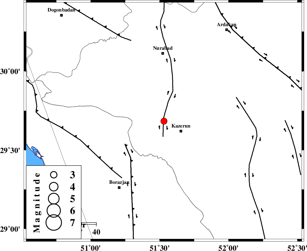
| Region | Fars Province, 14 km -West of Kazerun |
Nearest Cities |
|
| 4 km North of Deris, Fars Province | |
| 8 km North of Kamaraj, Fars Province | |
| 14 km North West of Kazerun, Fars Province | |
| 16 km South of Seyyed hasan, Fars Province | |
| 19 km North West of Mehranjan, Fars Province | |
| Depth | 15 km |
| Agency | |
Faults within 150 km: |
|
| KAZERUN_F (Length: 96 km) , Distance to epicenter: 2 km | |
| BORAZJAN_F (Length: 168 km) , Distance to epicenter: 32 km | |
| ZFF3 (Length: 125 km) , Distance to epicenter: 50 km | |
| Number of Phases | 6 |
| RMS | 0.7 |
| Number of Stations | 6 |
| Error in Latitude | >9.1 km |
| Error in Longitude | 6.8 km |
| Error in Depth | 0 km |
Download waveform in seisan format
to download seisan software Click here
to access information about IIEES stations Click here
Amplitude | ||||||||
| UID | Agency | Station | Component | Amplitude | Period | Arrival Time | Proccessing Time | Signal Clip |
| 112903 | IIEES | GHIR | E | 102.8 | 0.48 | 2017-02-02 07:52:58 | 2017-02-04 08:06:00 | n |
| 112904 | IIEES | GHIR | N | 131.7 | 0.36 | 2017-02-02 07:53:06 | 2017-02-04 08:06:00 | n |
| 112905 | IIEES | KRBR | E | 11.6 | 0.27 | 2017-02-02 07:54:03 | 2017-02-04 08:06:00 | n |
| 112906 | IIEES | KRBR | N | 8.7 | 0.36 | 2017-02-02 07:54:03 | 2017-02-04 08:06:00 | n |
| 112907 | IIEES | ASAO | E | 9.3 | 0.64 | 2017-02-02 07:54:06 | 2017-02-04 08:06:00 | n |
| 112908 | IIEES | ASAO | N | 6.7 | 0.64 | 2017-02-02 07:54:06 | 2017-02-04 08:06:00 | n |
Phase | ||||||||||||
| Agency | Station | Component | Phase Type | Phase Quality | First Motion | Observed Arrival Time | Time Residual | Loc. Flag | Input Weight | Distance | Azimuth | |
| IIEES | GHIR | Z | Pn | E | 2017-02-02 07:52:23 | 0.28 | y | 210 | 137 | |||
| IIEES | NASN | Z | Pn | E | 2017-02-02 07:52:42 | -0.19 | y | 366 | 19 | |||
| IIEES | YZKH | Z | Pn | E | 2017-02-02 07:52:50 | 1.16 | y | 419 | 43 | |||
| IIEES | KRBR | Z | Pn | E | 2017-02-02 07:52:58 | -1.21 | y | 506 | 85 | |||
| IIEES | ASAO | Z | Pn | E | 2017-02-02 07:53:05 | -0.46 | y | 558 | 346 | |||
| IIEES | SNGE | Z | Pn | E | 2017-02-02 07:53:26 | 0.14 | y | 717 | 328 | |||