
Magnitude |
:3.5 |
| Date & Time (UTC) | 2016-11-18 01:57:05.0 |
| Date & Time (Local) | 1395/8/28 05:27:05.0 |
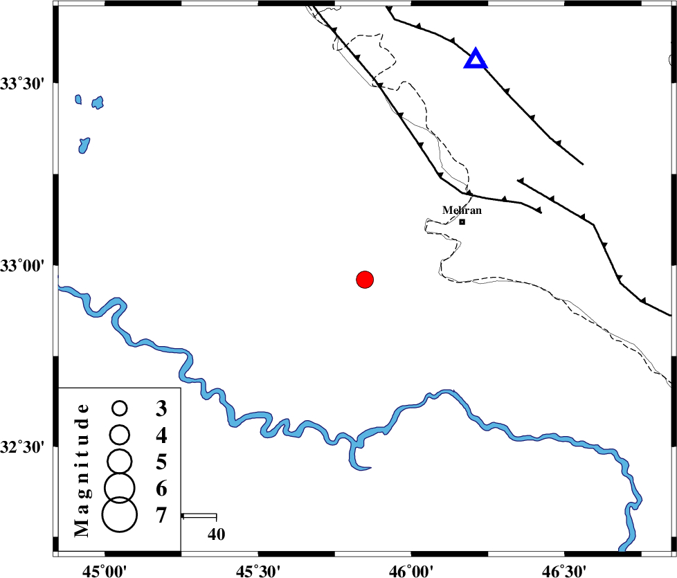
| Location | Lat:32.96 Lon: 45.848 |
| Region | Iraq, 35 km South-West of Mehran |
Nearest Cities |
|
| 35 km South West of Mehran, Ilam Province | |
| 65 km South West of Salehabad, Ilam Province | |
| 69 km South West of Galeh-yedarre-hemalakshahi, Ilam Province | |
| 73 km South West of Gonbad-e pirmohammad, Ilam Province | |
| 79 km South West of Mehr, Ilam Province | |
| Depth | 6 km |
| Agency | |
Faults within 150 km: |
|
| ZFF4 (Length: 128 km) , Distance to epicenter: 39 km | |
| MFF6 (Length: 144 km) , Distance to epicenter: 55 km | |
| MFF7 (Length: 99 km) , Distance to epicenter: 71 km | |
| Number of Phases | 8 |
| RMS | 0.2 |
| Number of Stations | 6 |
| Error in Latitude | >4.3 km |
| Error in Longitude | 8.3 km |
| Error in Depth | 6.2 km |
Download waveform in seisan format
to download seisan software Click here
to access information about IIEES stations Click here
Amplitude | ||||||||
| UID | Agency | Station | Component | Amplitude | Period | Arrival Time | Proccessing Time | Signal Clip |
| 110783 | IIEES | ILBA | N | 2778.8 | 0.57 | 2016-11-18 01:57:32 | 2016-11-19 09:35:00 | n |
| 110784 | IIEES | ILBA | E | 2719.6 | 0.68 | 2016-11-18 01:57:43 | 2016-11-19 09:35:00 | n |
| 110785 | IIEES | SNGE | N | 158 | 0.46 | 2016-11-18 01:58:31 | 2016-11-19 09:35:00 | n |
| 110786 | IIEES | SNGE | E | 162.1 | 0.66 | 2016-11-18 01:58:34 | 2016-11-19 09:35:00 | n |
| 110787 | IIEES | GHVR | E | 17 | 0.54 | 2016-11-18 01:59:30 | 2016-11-19 09:35:00 | n |
Phase | ||||||||||||
| Agency | Station | Component | Phase Type | Phase Quality | First Motion | Observed Arrival Time | Time Residual | Loc. Flag | Input Weight | Distance | Azimuth | |
| IIEES | ILBA | Z | Pg | E | 2016-11-18 01:57:19 | -0.04 | y | 80.9 | 24 | |||
| IIEES | ILBA | N | Sg | E | 2016-11-18 01:57:29 | 0 | y | 80.9 | 24 | |||
| IIEES | SNGE | Z | Pn | E | 2016-11-18 01:57:48 | 0.15 | y | 274 | 30 | |||
| IIEES | KHMZ | Z | Pn | E | 2016-11-18 01:58:02 | -0.2 | y | 393 | 76 | |||
| IIEES | ASAO | Z | Pn | E | 2016-11-18 01:58:06 | -0.01 | y | 425 | 64 | |||
| IIEES | ZNJK | Z | Pn | E | 2016-11-18 01:58:14 | -0.18 | y | 487 | 31 | |||
| IIEES | GHVR | Z | Pn | E | 2016-11-18 01:58:19 | 0.3 | y | 528 | 70 | |||
| IIEES | CHTH | Z | Pn | E | 2016-11-18 01:58:25 | -1.11 | n | 4 | 585 | 55 | ||