
Magnitude |
:3.8 |
| Date & Time (UTC) | 2013-08-04 21:38:44.0 |
| Date & Time (Local) | 1392/5/14 02:08:44.0 |
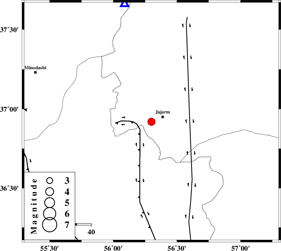
| Location | Lat:36.92 Lon: 56.3 |
| Region | Khorasan(north) Province, 9 km Jajarm |
Nearest Cities |
|
| 8 km of Garmeh, Khorasan(north) Province | |
| 9 km of Jajarm, Khorasan(north) Province | |
| 47 km South East of Nardin, Semnan Province | |
| 48 km North West of Farashiyan, Khorasan(center) Province | |
| 58 km South East of Rezvan, Semnan Province | |
| Depth | 14 km |
| Agency | |
Faults within 150 km: |
|
| JAJARAM_F (Length: 77 km) , Distance to epicenter: 3 km | |
| ROBATE_QARABIL_F (Length: 168 km) , Distance to epicenter: 34 km | |
| JOGHATAI_F (Length: 70 km) , Distance to epicenter: 41 km | |
| Number of Phases | 6 |
| RMS | 0.1 |
| Number of Stations | 5 |
| Error in Latitude | >1.6 km |
| Error in Longitude | 7.9 km |
| Error in Depth | 3.6 km |
Download waveform in seisan format
to download seisan software Click here
to access information about IIEES stations Click here
Amplitude | ||||||||
| UID | Agency | Station | Component | Amplitude | Period | Arrival Time | Proccessing Time | Signal Clip |
| 90125 | IIEES | KRBR | E | 16.4 | 0.68 | 2013-08-04 21:42:43 | 2013-08-04 11:04:00 | n |
| 90126 | IIEES | KRBR | N | 15.6 | 0.68 | 2013-08-04 21:42:54 | 2013-08-04 11:04:00 | n |
Phase | ||||||||||||
| Agency | Station | Component | Phase Type | Phase Quality | First Motion | Observed Arrival Time | Time Residual | Loc. Flag | Input Weight | Distance | Azimuth | |
| IIEES | MRVT | Z | Pg | E | 2013-08-04 21:38:58 | 0.03 | y | 83.9 | 347 | |||
| IIEES | MRVT | E | Sg | E | 2013-08-04 21:39:08 | -0.02 | y | 83.9 | 347 | |||
| IIEES | TABS | Z | Pn | E | 2013-08-04 21:39:37 | 0.12 | y | 371 | 168 | |||
| IIEES | TABS | E | Sg | E | 2013-08-04 21:40:27 | -0.01 | y | 371 | 168 | |||
| IIEES | YZKH | Z | Pn | E | 2013-08-04 21:39:57 | -0.05 | y | 526 | 198 | |||
| IIEES | BSRN | Z | Pn | E | 2013-08-04 21:40:07 | -0.13 | y | 608 | 154 | |||