
Magnitude |
:2.5 |
| Date & Time (UTC) | 2011-02-08 04:56:06.8 |
| Date & Time (Local) | 1389/11/19 08:26:06.8 |
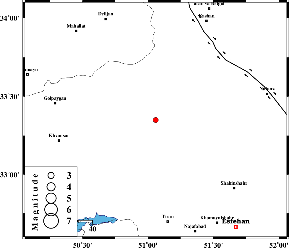
| Location | Lat:33.35 Lon: 51.06 |
| Region | Esfahan Province, 73 km North of Tiran |
Nearest Cities |
|
| 14 km West of Vazvan, Esfahan Province | |
| 14 km West of Vandadeh, Esfahan Province | |
| 15 km West of Meymeh, Esfahan Province | |
| 24 km East of Hasan robat, Esfahan Province | |
| 29 km North East of Dehaq, Esfahan Province | |
| Depth | 14 km |
| Agency | |
Faults within 150 km: |
|
| ZEFREH_F (Length: 124 km) , Distance to epicenter: 65 km | |
| KASHAN_F (Length: 44 km) , Distance to epicenter: 66 km | |
| CHAH_ZANGUL_F (Length: 123 km) , Distance to epicenter: 99 km | |
| Number of Phases | 6 |
| RMS | 0.2 |
| Number of Stations | 5 |
| Error in Latitude | >2.4 km |
| Error in Longitude | 3 km |
| Error in Depth | 6.4 km |
Download waveform in seisan format
to download seisan software Click here
to access information about IIEES stations Click here
Amplitude | ||||||||
| UID | Agency | Station | Component | Amplitude | Period | Arrival Time | Proccessing Time | Signal Clip |
| 77846 | IIEES | DAMV | E | 25.4 | 0.4 | 2011-02-08 04:57:23 | 2011-02-08 05:13:00 | n |
Phase | ||||||||||||
| Agency | Station | Component | Phase Type | Phase Quality | First Motion | Observed Arrival Time | Time Residual | Loc. Flag | Input Weight | Distance | Azimuth | |
| IIEES | KHMZ | Z | Pg | E | 2011-02-08 04:56:25 | 0.1 | y | 111 | 293 | |||
| IIEES | GHVR | Z | Pg | E | 2011-02-08 04:56:28 | 0.3 | y | 126 | 8 | |||
| IIEES | GHVR | N | Sg | E | 2011-02-08 04:56:43 | -0.1 | y | 126 | 8 | |||
| IIEES | ASAO | Z | Pg | E | 2011-02-08 04:56:33 | -0.3 | y | 164 | 324 | |||
| IIEES | NASN | Z | Pg | E | 2011-02-08 04:56:35 | -0.1 | y | 174 | 110 | |||
| IIEES | DAMV | Z | Pn | E | 2011-02-08 04:56:47 | 0.1 | y | 266 | 18 | |||