
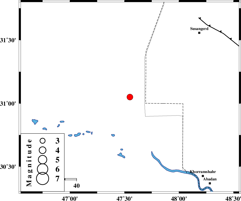
Magnitude |
:3.5 |
| Date & Time (UTC) | 2011-01-18 10:44:30.9 |
| Date & Time (Local) | 1389/10/28 14:14:30.9 |
| Location | Lat:31.05 Lon: 47.55 |
| Region | Iraq, 63 km North-West of Al Basrah |
Nearest Cities |
|
| 64 km North West of Al Basrah, Iraq Province | |
| 68 km South West of Hoveizeh, Khoozestan Province | |
| 83 km South West of Susangerd, Khoozestan Province | |
| 86 km South West of Bostan, Khoozestan Province | |
| 86 km North West of Polno, Khoozestan Province | |
| Depth | 15 km |
| Agency | |
Faults within 150 km: |
|
| AHVAZ_F (Length: 99 km) , Distance to epicenter: 92 km | |
| Number of Phases | 7 |
| RMS | 0.2 |
| Number of Stations | 6 |
| Error in Latitude | >7.6 km |
| Error in Longitude | 7.1 km |
| Error in Depth | 8.4 km |
Download waveform in seisan format
to download seisan software Click here
to access information about IIEES stations Click here
Amplitude | ||||||||
| UID | Agency | Station | Component | Amplitude | Period | Arrival Time | Proccessing Time | Signal Clip |
| 77214 | IIEES | SHGR | E | 766.4 | 0.56 | 2011-01-18 10:45:25 | 2011-01-18 11:09:00 | n |
| 77215 | IIEES | SHGR | N | 643.3 | 0.62 | 2011-01-18 10:45:26 | 2011-01-18 11:09:00 | n |
| 77216 | IIEES | GHVR | N | 28.8 | 0.56 | 2011-01-18 10:46:43 | 2011-01-18 11:09:00 | n |
Phase | ||||||||||||
| Agency | Station | Component | Phase Type | Phase Quality | First Motion | Observed Arrival Time | Time Residual | Loc. Flag | Input Weight | Distance | Azimuth | |
| IIEES | SHGR | Z | Pg | E | 2011-01-18 10:44:58 | 0.1 | y | 167 | 45 | |||
| IIEES | SHGR | N | Sg | E | 2011-01-18 10:45:18 | -0.1 | y | 167 | 45 | |||
| IIEES | KHMZ | Z | Pn | E | 2011-01-18 10:45:25 | 0.4 | y | 375 | 37 | |||
| IIEES | SNGE | Z | Pn | E | 2011-01-18 10:45:34 | -0.2 | y | 449 | 358 | |||
| IIEES | ASAO | Z | Pn | E | 2011-01-18 10:45:34 | -0.1 | y | 452 | 30 | |||
| IIEES | GHVR | Z | Pn | E | 2011-01-18 10:45:42 | 0.1 | y | 515 | 41 | |||
| IIEES | NASN | Z | Pn | E | 2011-01-18 10:45:44 | -0.3 | y | 534 | 67 | |||