
Magnitude |
:3.1 |
| Date & Time (UTC) | 2010-12-27 10:57:22.0 |
| Date & Time (Local) | 1389/10/6 14:27:22.0 |
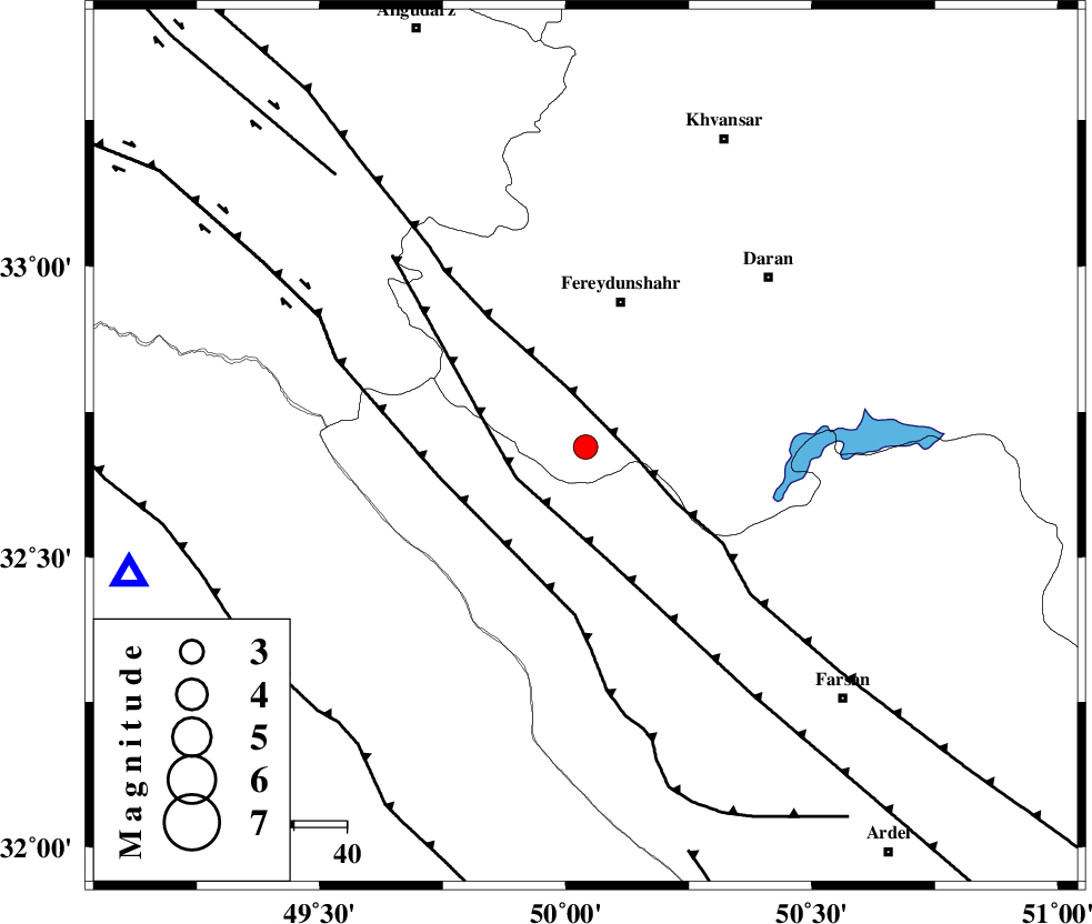
| Location | Lat:32.69 Lon: 50.04 |
| Region | Esfahan Province, 26 km North of Chelgard |
Nearest Cities |
|
| 17 km East of Durak, Chaharmahal Bakhtiari Province | |
| 18 km West of Ghale? sorkh, Esfahan Province | |
| 22 km South of Sibak, Esfahan Province | |
| 25 km South East of Masir, Esfahan Province | |
| 26 km North of Chelgard, Chaharmahal Bakhtiari Province | |
| Depth | 16 km |
| Agency | |
Faults within 150 km: |
|
| MAIN_ZAGROS_R_F (Length: 1106 km) , Distance to epicenter: 11 km | |
| ARDAL_F (Length: 170 km) , Distance to epicenter: 14 km | |
| ZARDKUH_F (Length: 139 km) , Distance to epicenter: 28 km | |
| Number of Phases | 5 |
| RMS | 0.1 |
| Number of Stations | 5 |
| Error in Latitude | >2.2 km |
| Error in Longitude | 3.9 km |
| Error in Depth | 6 km |
Download waveform in seisan format
to download seisan software Click here
to access information about IIEES stations Click here
Amplitude | ||||||||
| UID | Agency | Station | Component | Amplitude | Period | Arrival Time | Proccessing Time | Signal Clip |
| 76550 | IIEES | SHGR | N | 505.2 | 0.63 | 2010-12-27 10:58:11 | 2010-12-27 11:11:00 | n |
| 76551 | IIEES | SHGR | E | 453.6 | 0.52 | 2010-12-27 10:58:13 | 2010-12-27 11:11:00 | n |
| 76552 | IIEES | GHVR | E | 88 | 0.55 | 2010-12-27 10:58:36 | 2010-12-27 11:11:00 | n |
| 76553 | IIEES | NASN | E | 77.8 | 0.49 | 2010-12-27 10:58:40 | 2010-12-27 11:11:00 | n |
Phase | ||||||||||||
| Agency | Station | Component | Phase Type | Phase Quality | First Motion | Observed Arrival Time | Time Residual | Loc. Flag | Input Weight | Distance | Azimuth | |
| IIEES | KHMZ | Z | Pg | E | 2010-12-27 10:57:41 | 0.2 | y | 117 | 357 | |||
| IIEES | KHMZ | E | Sg | E | 2010-12-27 10:57:56 | -0.2 | y | 117 | 357 | |||
| IIEES | SHGR | Z | Pg | E | 2010-12-27 10:57:44 | -0.1 | y | 133 | 241 | |||
| IIEES | NASN | Z | Pn | E | 2010-12-27 10:58:02 | 0 | y | 260 | 87 | |||
| IIEES | SNGE | Z | Pn | E | 2010-12-27 10:58:15 | 0 | y | 365 | 318 | |||